Estimated Value: $290,117 - $388,000
Studio
3
Baths
2,275
Sq Ft
$151/Sq Ft
Est. Value
About This Home
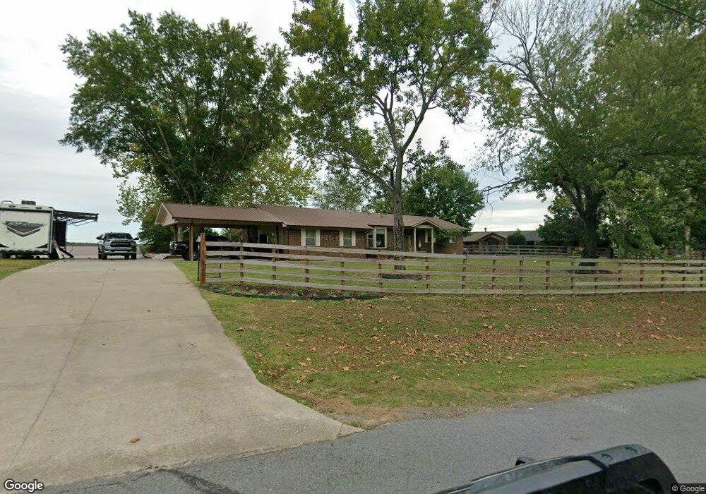
This home is located at 312 Dugger Rd, Beebe, AR 72012 and is currently estimated at $344,529, approximately $151 per square foot. 312 Dugger Rd is a home located in White County with nearby schools including Beebe Elementary School, Beebe Junior High School, and Beebe Middle School.
Ownership History
Date
Name
Owned For
Owner Type
Purchase Details
Closed on
Aug 31, 2020
Sold by
Weatherford Shannon
Bought by
Weatherford Jason
Current Estimated Value
Purchase Details
Closed on
Feb 28, 2018
Sold by
Weatherford Benny Reid and Weatherford Terry Parker
Bought by
Weatherford Jason
Purchase Details
Closed on
Nov 27, 2011
Bought by
Weatherford Fam Tr #1
Purchase Details
Closed on
Sep 9, 2011
Bought by
Weatherford Fam Tr
Purchase Details
Closed on
Mar 7, 1997
Bought by
Weatherford Benny and Weatherford Terry
Purchase Details
Closed on
Aug 1, 1993
Bought by
Denton Denton J and Denton Manley
Create a Home Valuation Report for This Property
The Home Valuation Report is an in-depth analysis detailing your home's value as well as a comparison with similar homes in the area
Purchase History
| Date | Buyer | Sale Price | Title Company |
|---|---|---|---|
| Weatherford Jason | -- | None Available | |
| Weatherford Jason | -- | None Available | |
| Weatherford Fam Tr #1 | -- | -- | |
| Weatherford Fam Tr | -- | -- | |
| Weatherford Benny | $79,000 | -- | |
| Denton Denton J | $70,000 | -- |
Source: Public Records
Tax History
| Year | Tax Paid | Tax Assessment Tax Assessment Total Assessment is a certain percentage of the fair market value that is determined by local assessors to be the total taxable value of land and additions on the property. | Land | Improvement |
|---|---|---|---|---|
| 2025 | $1,904 | $46,790 | $5,700 | $41,090 |
| 2024 | $1,904 | $46,790 | $5,700 | $41,090 |
| 2023 | $1,901 | $46,790 | $5,700 | $41,090 |
| 2022 | $1,758 | $46,790 | $5,700 | $41,090 |
| 2021 | $1,615 | $46,790 | $5,700 | $41,090 |
| 2020 | $1,471 | $35,170 | $4,400 | $30,770 |
| 2019 | $1,471 | $35,170 | $4,400 | $30,770 |
| 2018 | $1,471 | $35,170 | $4,400 | $30,770 |
| 2017 | $1,244 | $35,170 | $4,400 | $30,770 |
| 2016 | $1,244 | $30,570 | $4,400 | $26,170 |
| 2015 | $1,131 | $27,790 | $4,350 | $23,440 |
| 2014 | $1,131 | $27,790 | $4,350 | $23,440 |
Source: Public Records
Map
Nearby Homes
- 311 Dugger Rd
- 271 Dugger Rd
- 235 Dugger Rd
- 729 Swinging Bridge Rd
- 101 W Lake Cove
- Rc Fenway Plan at Bellingrath
- Rc Wright Plan at Bellingrath
- Rc Guthrie Plan at Bellingrath
- Rc Franklin Plan at Bellingrath
- Rc Foster II Plan at Bellingrath
- Rc Keswick Plan at Bellingrath
- Rc Clark Plan at Bellingrath
- Rc Lowell II Plan at Bellingrath
- Rc Kinsley II Plan at Bellingrath
- 127 Dugger Rd
- 106 Prairie Dr
- Tract 4 Artesia Ln
- Tract 11 Artesia Ln
- Tract 9 Artesia Ln
- 104 Autumn Ln
Your Personal Tour Guide
Ask me questions while you tour the home.