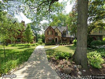
321 Scottswood Rd Riverside, IL 60546
Estimated Value: $505,635 - $663,000
3
Beds
2
Baths
1,740
Sq Ft
$342/Sq Ft
Est. Value
About This Home
This home is located at 321 Scottswood Rd, Riverside, IL 60546 and is currently estimated at $595,909, approximately $342 per square foot. 321 Scottswood Rd is a home located in Cook County with nearby schools including Central Elementary School, L J Hauser Jr High School, and Riverside Brookfield High School.
Ownership History
Date
Name
Owned For
Owner Type
Purchase Details
Closed on
Sep 15, 2000
Sold by
First American Bank
Bought by
Hawk Stephen R and Hawk Marie E
Current Estimated Value
Home Financials for this Owner
Home Financials are based on the most recent Mortgage that was taken out on this home.
Original Mortgage
$216,000
Interest Rate
8.05%
Mortgage Type
Unknown
Create a Home Valuation Report for This Property
The Home Valuation Report is an in-depth analysis detailing your home's value as well as a comparison with similar homes in the area
Home Values in the Area
Average Home Value in this Area
Purchase History
| Date | Buyer | Sale Price | Title Company |
|---|---|---|---|
| Hawk Stephen R | $411,000 | -- |
Source: Public Records
Mortgage History
| Date | Status | Borrower | Loan Amount |
|---|---|---|---|
| Open | Hawk Stephen R | $233,000 | |
| Closed | Hawk Stephen | $241,000 | |
| Closed | Hawk Stephen | $247,000 | |
| Closed | Hawk Stephen R | $100,000 | |
| Closed | Hawk Stephen R | $237,000 | |
| Closed | Hawk Stephen R | $212,600 | |
| Closed | Hawk Stephen R | $214,000 | |
| Closed | Hawk Stephen R | $50,000 | |
| Closed | Hawk Stephen R | $215,000 | |
| Closed | Hawk Stephen R | $216,000 |
Source: Public Records
Tax History Compared to Growth
Tax History
| Year | Tax Paid | Tax Assessment Tax Assessment Total Assessment is a certain percentage of the fair market value that is determined by local assessors to be the total taxable value of land and additions on the property. | Land | Improvement |
|---|---|---|---|---|
| 2024 | $10,964 | $48,000 | $9,849 | $38,151 |
| 2023 | $10,964 | $48,000 | $9,849 | $38,151 |
| 2022 | $10,964 | $32,240 | $8,506 | $23,734 |
| 2021 | $10,577 | $32,240 | $8,506 | $23,734 |
| 2020 | $10,316 | $32,240 | $8,506 | $23,734 |
| 2019 | $12,977 | $40,421 | $7,834 | $32,587 |
| 2018 | $12,606 | $40,421 | $7,834 | $32,587 |
| 2017 | $12,222 | $40,421 | $7,834 | $32,587 |
| 2016 | $9,814 | $30,396 | $6,715 | $23,681 |
| 2015 | $9,549 | $30,396 | $6,715 | $23,681 |
| 2014 | $9,408 | $30,396 | $6,715 | $23,681 |
| 2013 | $10,130 | $35,077 | $6,715 | $28,362 |
Source: Public Records
Map
Nearby Homes
- 177 Scottswood Rd
- 208 Fairbank Rd
- 3845 Mccormick Ave
- 4041 Rose Ave
- 4030 Joliet Ave Unit 1
- 8502 Brookfield Ave
- 8636 40th St
- 8 West Ave
- 8621 43rd St
- 50 West Ave Unit 1S
- 4234 Prescott Ave
- 128 Forest Ave
- 7846 White Ave
- 8611 44th St
- 4247 Amelia Ave Unit 1C
- 50 Forest Ave Unit 3S
- 8718 Plainfield Rd
- 4322 Amelia Ave
- 4337 Prescott Ave
- 8223 45th St
- 321 Scottswood Rd
- 317 Scottswood Rd
- 325 Scottswood Rd
- 315 Scottswood Rd
- 305 Scottswood Rd
- 329 Scottswood Rd
- 368 Fairbank Rd
- 372 Fairbank Rd
- 314 Scottswood Rd
- 360 Fairbank Rd
- 360 Fairbank Rd
- 301 Scottswood Rd
- 350 Fairbank Rd
- 380 Fairbank Rd
- 310 Scottswood Rd
- 322 Scottswood Rd
- 297 Scottswood Rd
- 340 Fairbank Rd
- 293 Scottswood Rd
- 299 Bloomingbank Rd