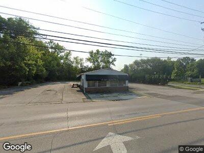
339 S Sandusky St Delaware, OH 43015
Estimated Value: $247,409
--
Bed
--
Bath
1,238
Sq Ft
$200/Sq Ft
Est. Value
About This Home
This home is located at 339 S Sandusky St, Delaware, OH 43015 and is currently estimated at $247,409, approximately $199 per square foot. 339 S Sandusky St is a home located in Delaware County with nearby schools including Laura Woodward Elementary School, John C. Dempsey Middle School, and Rutherford B. Hayes High School.
Ownership History
Date
Name
Owned For
Owner Type
Purchase Details
Closed on
Jan 28, 2025
Sold by
Snekcid Llc
Bought by
Eab Holdings Llc
Current Estimated Value
Purchase Details
Closed on
Nov 17, 2021
Sold by
Redhawk Property Investments Llc
Bought by
Snekcid Llc
Purchase Details
Closed on
Dec 9, 2016
Sold by
Rife Michael Allen and Rife Victoria Ann
Bought by
Redhawk Property Investments Llc
Purchase Details
Closed on
Feb 22, 2012
Sold by
Rife Victoria Ann and Rife Victoria Ann
Bought by
Rife Victoria Ann and Rife Michael Allen
Purchase Details
Closed on
Oct 13, 2011
Sold by
Rife Bictoria A
Bought by
Rife Victoria Ann Link
Purchase Details
Closed on
Oct 8, 2004
Sold by
Link William Lloyd and Link Sarah Jean
Bought by
Link Sarah J
Create a Home Valuation Report for This Property
The Home Valuation Report is an in-depth analysis detailing your home's value as well as a comparison with similar homes in the area
Home Values in the Area
Average Home Value in this Area
Purchase History
| Date | Buyer | Sale Price | Title Company |
|---|---|---|---|
| Eab Holdings Llc | $246,300 | None Listed On Document | |
| Eab Holdings Llc | $246,300 | None Listed On Document | |
| Snekcid Llc | $150,000 | Elite Land Title | |
| Redhawk Property Investments Llc | $122,000 | Attorney | |
| Rife Victoria Ann | -- | None Available | |
| Rife Victoria Ann Link | -- | Attorney | |
| Link Sarah J | -- | Chicago Title |
Source: Public Records
Tax History Compared to Growth
Tax History
| Year | Tax Paid | Tax Assessment Tax Assessment Total Assessment is a certain percentage of the fair market value that is determined by local assessors to be the total taxable value of land and additions on the property. | Land | Improvement |
|---|---|---|---|---|
| 2024 | $3,079 | $55,520 | $40,080 | $15,440 |
| 2023 | $3,085 | $55,520 | $40,080 | $15,440 |
| 2022 | $3,180 | $48,970 | $33,220 | $15,750 |
| 2021 | $3,274 | $48,970 | $33,220 | $15,750 |
| 2020 | $3,352 | $48,970 | $33,220 | $15,750 |
| 2019 | $3,627 | $48,970 | $33,220 | $15,750 |
| 2018 | $3,708 | $48,970 | $33,220 | $15,750 |
| 2017 | $1,842 | $46,380 | $33,220 | $13,160 |
| 2016 | $3,221 | $46,380 | $33,220 | $13,160 |
| 2015 | $3,240 | $46,380 | $33,220 | $13,160 |
| 2014 | -- | $46,380 | $33,220 | $13,160 |
| 2013 | $3,308 | $46,380 | $33,220 | $13,160 |
Source: Public Records
Map
Nearby Homes
- 0 S Sandusky St Unit 224007383
- 333 S Sandusky St
- 2588 Bellgrove Place
- 31 High St
- 50 Winter Pine Dr
- 25 David St
- 62 S Washington St
- 45 Winter Pine Dr
- 45 Ravine Ridge Dr
- 25 Ravine Ridge Dr
- 8 Winter Pine Dr
- 7338 Sunrise Way
- 975 Village Dr
- 726 Holly Rd
- 857 Village Dr Unit 857
- 40 W Winter St
- 249 Rochdale Run
- 22 Elizabeth St
- 0 Dildine Rd Unit 225015764
- 0 Hills Miller Rd Unit 225015405
- 0 S Sandusky St Unit 2429994
- 0 S Sandusky St Unit 2532995
- 0 S Sandusky St Unit 2116798
- 0 S Sandusky St Unit 2544499
- 0 S Sandusky St Unit 224002643
- 0 S Sandusky St Unit 221015158
- 0 S Sandusky St Unit 215004819
- 0 S Sandusky St Unit 220003205
- 0 S Sandusky St
- 371 S Sandusky St
- 391 S Sandusky St
- 330 S Sandusky St
- 315 S Sandusky St
- 18 Weiser Ave
- 311 S Sandusky St
- 24 Hoyt St
- 305 S Sandusky St
- 310 S Sandusky St
- 34 Weiser Ave
- 407 S Sandusky St
