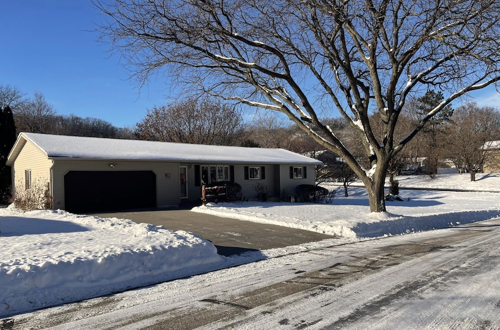

3557 Skyline Dr Red Wing, MN 55066
Estimated payment $1,922/month
Highlights
- Deck
- No HOA
- The kitchen features windows
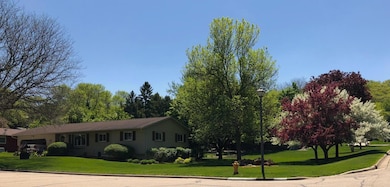
- Corner Lot
- Den
- 2 Car Attached Garage
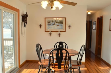
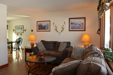
About This Home
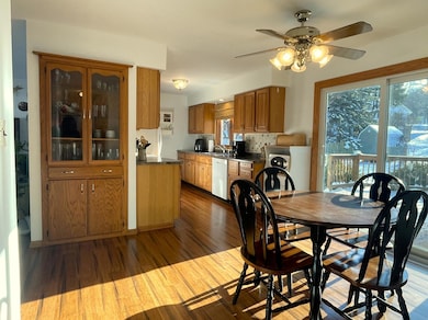
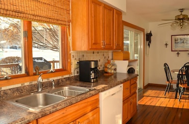
This handsome home is situated on a spacious lot with a prime location near two City Parks. Its main features include: rich Hickory cabinetry that adds warmth and sophistication to the home's interior, a built-in China cupboard for elegant storage, a Bow Window that provides abundant natural light, a Ceramic bath for a modern touch, and an oversized garage with generous space for vehicles and storage. Its lower-level amenities include: a large family room perfect for gatherings and relaxation, a comfortable den suitable for work or leisure, a laundry area equipped with ample storage, and a three-quarter bath for added convenience. Discover the thoughtful features and prime location which makes 3557 Skyline Drive an exceptional choice for comfortable living.
Home Details
Home Type
- Single Family
Est. Annual Taxes
- $3,168
Year Built
- Built in 1972
Lot Details
- 0.34 Acre Lot
- Lot Dimensions are 132x110
- Corner Lot
- Few Trees
Parking
- 2 Car Attached Garage
- Garage Door Opener
Home Design
- Vinyl Siding
Interior Spaces
- 1-Story Property
- Family Room
- Living Room
- Dining Room
- Den
Kitchen
- Eat-In Kitchen
- Range
- Dishwasher
- The kitchen features windows
Bedrooms and Bathrooms
- 3 Bedrooms
Laundry
- Dryer
- Washer
Finished Basement
- Basement Fills Entire Space Under The House
- Block Basement Construction
- Basement Storage
- Natural lighting in basement
Outdoor Features
- Deck
Utilities
- Forced Air Heating and Cooling System
- Vented Exhaust Fan
- Underground Utilities
- 100 Amp Service
- Gas Water Heater
- Water Softener is Owned
Community Details
- No Home Owners Association
- Hiawatha Hills Add Subdivision
Listing and Financial Details
- Assessor Parcel Number 558550100
Map
Home Values in the Area
Average Home Value in this Area
Tax History
| Year | Tax Paid | Tax Assessment Tax Assessment Total Assessment is a certain percentage of the fair market value that is determined by local assessors to be the total taxable value of land and additions on the property. | Land | Improvement |
|---|---|---|---|---|
| 2025 | $3,168 | $258,700 | $69,500 | $189,200 |
| 2024 | $3,168 | $254,400 | $69,500 | $184,900 |
| 2023 | $1,592 | $240,900 | $69,600 | $171,300 |
| 2022 | $2,768 | $231,500 | $61,500 | $170,000 |
| 2021 | $2,590 | $201,300 | $61,500 | $139,800 |
| 2020 | $2,588 | $192,100 | $61,500 | $130,600 |
| 2019 | $2,566 | $180,700 | $61,500 | $119,200 |
| 2018 | $2,092 | $181,200 | $59,600 | $121,600 |
| 2017 | $2,032 | $161,800 | $59,600 | $102,200 |
| 2016 | $1,884 | $159,600 | $59,600 | $100,000 |
| 2015 | $1,820 | $155,900 | $59,600 | $96,300 |
| 2014 | -- | $150,600 | $59,600 | $91,000 |
Property History
| Date | Event | Price | List to Sale | Price per Sq Ft |
|---|---|---|---|---|
| 12/04/2025 12/04/25 | For Sale | $314,850 | -- | $160 / Sq Ft |
Purchase History
| Date | Type | Sale Price | Title Company |
|---|---|---|---|
| Warranty Deed | $176,000 | -- | |
| Warranty Deed | $138,000 | -- | |
| Warranty Deed | $112,500 | -- |
Source: NorthstarMLS
MLS Number: 6824430
APN: 55.855.0100
Disclaimer: Certain information contained herein is derived from information provided by parties other than Homes.com. All information provided is deemed reliable, but is not guaranteed to be accurate and should be independently verified.
![]() Based on information submitted to the MLS GRID. All data is obtained from various sources and may not have been verified by broker or MLS GRID. Supplied Open House Information is subject to change without notice. All information should be independently reviewed and verified for accuracy. Properties may or may not be listed by the office/agent presenting the information. Some IDX listings have been excluded from this website.
Based on information submitted to the MLS GRID. All data is obtained from various sources and may not have been verified by broker or MLS GRID. Supplied Open House Information is subject to change without notice. All information should be independently reviewed and verified for accuracy. Properties may or may not be listed by the office/agent presenting the information. Some IDX listings have been excluded from this website.
The Digital Millennium Copyright Act of 1998, 17 U.S.C. § 512 (the “DMCA”) provides recourse for copyright owners who believe that material appearing on the Internet infringes their rights under U.S. copyright law. If you believe in good faith that any content or material made available in connection with our website or services infringes your copyright, you (or your agent) may send us a notice requesting that the content or material be removed, or access to it blocked.
Notices must be sent in writing by email to DMCAnotice@MLSGrid.com.
The DMCA requires that your notice of alleged copyright infringement include the following information:
(1) description of the copyrighted work that is the subject of claimed infringement;
(2) description of the alleged infringing content and information sufficient to permit us to locate the content;
(3) contact information for you, including your address, telephone number and email address;
(4) a statement by you that you have a good faith belief that the content in the manner complained of is not authorized by the copyright owner, or its agent, or by the operation of any law;
(5) a statement by you, signed under penalty of perjury, that the information in the notification is accurate and that you have the authority to enforce the copyrights that are claimed to be infringed; and
(6) a physical or electronic signature of the copyright owner or a person authorized to act on the copyright owner’s behalf. Failure to include all of the above information may result in the delay of the processing of your complaint.
- 3560 Graves Dr
- 922 Briarwood Dr
- 168 Johnson Ave
- 113 Burnside Ave S
- 137 Burnside Ave N
- 237 Motel Ave
- 1125 Hewitt Blvd
- 2773 Ridgeview Dr
- 2762 Ridgeview Dr
- 1180 Hewitt Blvd
- 1181 Hewitt Blvd
- 980 Aurora Cir
- 853 Aurora Cir
- 135 Kingswood Dr
- 1056 Birch Ave
- 4739 Big Sky Ct
- 921 Snowbird Dr
- 4786 Mount Hood Ln
- 906 Snowbird Dr
- 910 Snowbird Dr
- 237 Motel Ave
- 540 Tyler Rd S
- 520 Tyler Rd S
- 419 Main St
- 222 Bush St
- 314 W 4th St
- 752 McSorley St
- 1405 S Park St
- 260 S Plum St
- 76 Meggan Dr
- 74 Meggan Dr
- 2457 Yellowstone Dr
- 675 Laura St
- 2400 Voyageur Pkwy
- 301 5th St S Unit 1
- 325 33rd St W
- 415 Hickory Dr
- 551 18th St E
- 921 Pearl St Unit 2
- 2112 Spring St Unit 2
