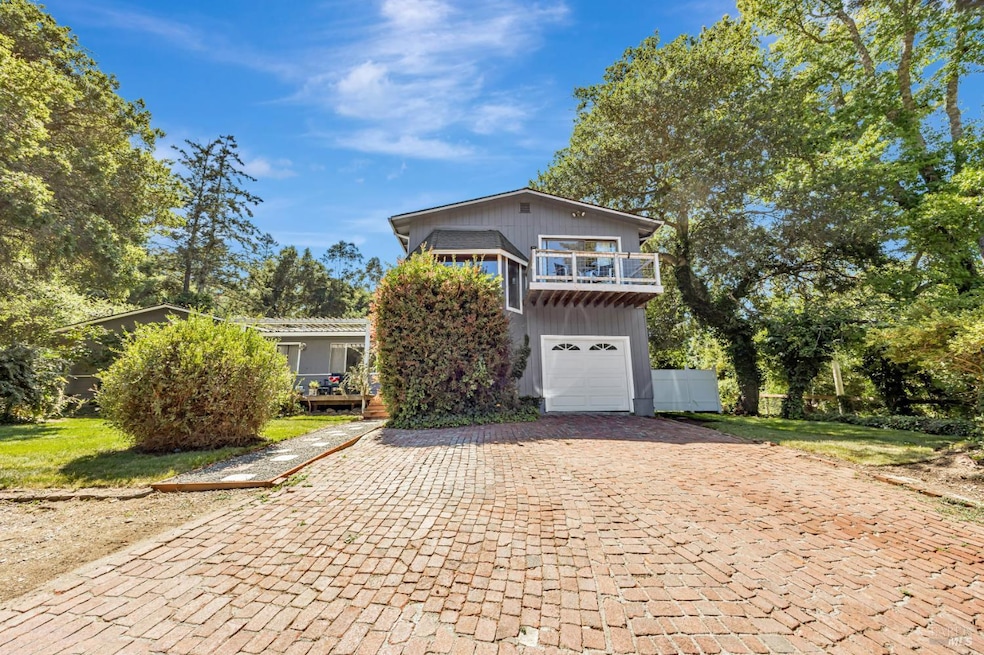
3590 Burnside Rd Sebastopol, CA 95472
Estimated payment $5,799/month
Highlights
- Second Garage
- Dining Room with Fireplace
- Secluded Lot
- Analy High School Rated A-
- Wood Burning Stove
- Wood Flooring
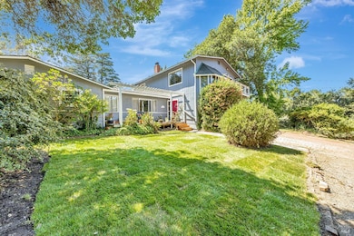
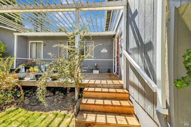
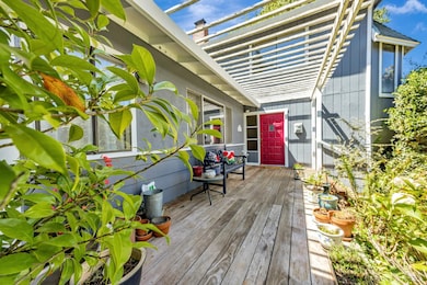
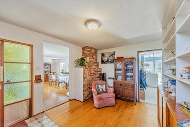
About This Home
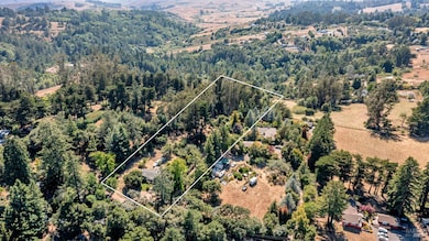
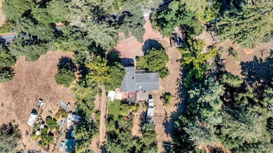
!!HUGE Price Reduction from original asking price!! Privacy, serenity, and boundless potential await you on nearly 4 usable acres in Sonoma County's peaceful countryside. Built in 1963, the original home offers timeless rustic charm and cozy country living. The main level features two spacious bedrooms and two full bathrooms. In addition to a large dining room with a wood-burning fireplace, a separate sunroom/family room, the laundry room, and an additional home office. While the upper level presents a special space perfect for a formal living connected to the master suite. Need workshop space? Use the detached 2-car garage, in addition to the 1-car garage attached to the home. Whether you envision building a multi-generational haven, a place for horses to roam, or the beginnings of your own boutique vineyard/orchard, this property truly offers the space and setting to bring it all to life. Bring your vision, your toolbelt, and your dreams! This is your opportunity to create something truly special in one of Sonoma County's most tranquil locations.
Co-Listing Agent
Shaka Folger-Basso
Coldwell Banker Realty License #02224339
Home Details
Home Type
- Single Family
Year Built
- Built in 1963
Lot Details
- 3.93 Acre Lot
- Wire Fence
- Landscaped
- Secluded Lot
- Garden
Parking
- 3 Car Garage
- 7 Open Parking Spaces
- Second Garage
- Workshop in Garage
Home Design
- Fixer Upper
- Concrete Foundation
- Composition Roof
- Wood Siding
Interior Spaces
- 2,236 Sq Ft Home
- 2-Story Property
- Beamed Ceilings
- Skylights
- Wood Burning Stove
- Brick Fireplace
- Formal Entry
- Family Room
- Living Room
- Dining Room with Fireplace
- 3 Fireplaces
- Formal Dining Room
- Den with Fireplace
- Storage
- Property Views
Kitchen
- Breakfast Room
- Walk-In Pantry
- Built-In Electric Oven
- Free-Standing Electric Oven
- Free-Standing Gas Range
- Range Hood
Flooring
- Wood
- Carpet
- Linoleum
- Laminate
Bedrooms and Bathrooms
- 3 Bedrooms
- Main Floor Bedroom
- Primary Bedroom Upstairs
- Bathroom on Main Level
- 3 Full Bathrooms
Laundry
- Laundry Room
- Laundry on main level
- 220 Volts In Laundry
- Washer and Dryer Hookup
Home Security
- Carbon Monoxide Detectors
- Fire and Smoke Detector
Outdoor Features
- Separate Outdoor Workshop
- Shed
- Outbuilding
Utilities
- No Cooling
- Central Heating
- 220 Volts
- Propane
- Water Holding Tank
- Well
- Abandoned Well
- Septic System
- Internet Available
Listing and Financial Details
- Assessor Parcel Number 073-040-007-000
Map
Tax History
| Year | Tax Paid | Tax Assessment Tax Assessment Total Assessment is a certain percentage of the fair market value that is determined by local assessors to be the total taxable value of land and additions on the property. | Land | Improvement |
|---|---|---|---|---|
| 2025 | $7,464 | $637,091 | $319,343 | $317,748 |
| 2024 | $7,464 | $624,600 | $313,082 | $311,518 |
| 2023 | $7,464 | $612,354 | $306,944 | $305,410 |
| 2022 | $7,097 | $600,348 | $300,926 | $299,422 |
| 2021 | $6,957 | $588,577 | $295,026 | $293,551 |
| 2020 | $6,993 | $582,542 | $292,001 | $290,541 |
| 2019 | $6,647 | $571,121 | $286,276 | $284,845 |
| 2018 | $6,537 | $559,923 | $280,663 | $279,260 |
| 2017 | $6,250 | $548,945 | $275,160 | $273,785 |
| 2016 | $6,146 | $538,182 | $269,765 | $268,417 |
| 2015 | $5,942 | $530,099 | $265,713 | $264,386 |
| 2014 | $5,821 | $519,717 | $260,509 | $259,208 |
Property History
| Date | Event | Price | List to Sale | Price per Sq Ft |
|---|---|---|---|---|
| 01/29/2026 01/29/26 | Price Changed | $995,000 | -9.5% | $445 / Sq Ft |
| 11/13/2025 11/13/25 | For Sale | $1,099,000 | -- | $492 / Sq Ft |
Purchase History
| Date | Type | Sale Price | Title Company |
|---|---|---|---|
| Interfamily Deed Transfer | -- | North American Title Co | |
| Grant Deed | $399,000 | Old Republic Title Company |
Mortgage History
| Date | Status | Loan Amount | Loan Type |
|---|---|---|---|
| Open | $320,000 | Unknown | |
| Closed | $214,000 | No Value Available |
Source: Bay Area Real Estate Information Services (BAREIS)
MLS Number: 325098142
APN: 073-040-007
Disclaimer: Certain information contained herein is derived from information provided by parties other than Homes.com. All information provided is deemed reliable, but is not guaranteed to be accurate and should be independently verified.
![]() Listing information deemed reliable but not guaranteed. Copyright 2026 Bay Area Real Estate Information Services, Inc. All Right Reserved.
Listing information deemed reliable but not guaranteed. Copyright 2026 Bay Area Real Estate Information Services, Inc. All Right Reserved.
- 10360 Barnett Valley Rd
- 10966 Barnett Valley Rd
- 189 Wagnon Rd
- 13881 Bodega Hwy
- 1455 Valley Ford Freestone Rd
- 1025 Laurel Ave
- 790 Ferguson Rd Rd
- 808 Grandview Rd
- 3336 Bloomfield Rd
- 940 Ferguson Rd
- 0 Bodega Hwy
- 789 Pleasant Hill Rd
- 3545 Bloomfield Rd
- 1430 Santa Maria Way
- 8061 Elphick Rd
- 8148 Bodega Ave
- 8086 Bodega Ave
- 200 Pleasant Hill Ave N
- 1365 Grandview Rd
- 1417 Deer Ln
- 3005 Blucher Valley Rd
- 7502 Bodega Ave Unit 7508 Washington Ave.
- 385 Murphy Ave Unit na
- 3485 Frei Rd
- 6600 Guerneville Rd
- 1001 Doubles Dr
- 965 Doubles Dr
- 6515 Front St
- 600 Rohnert Park Expy W
- 1501 Patty Place
- 5102 Dowdell Ave
- 541 Carlson Ave
- 5121 Dowdell Ave
- 381 Wall Place
- 1481 Wrigley Ave
- 155 Stony Point Rd
- 3753 Santa Rosa Ave Unit E
- 2120 Jennings Ave
- 100 Avram Ave
- 41 Ocean View Ave
