Estimated Value: $1,043,903 - $1,180,000
4
Beds
3
Baths
3,178
Sq Ft
$355/Sq Ft
Est. Value
About This Home
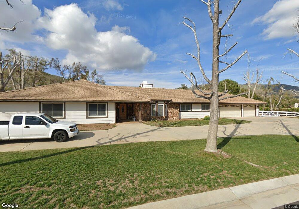
This home is located at 3625 Canter Ln, Acton, CA 93510 and is currently estimated at $1,127,226, approximately $354 per square foot. 3625 Canter Ln is a home located in Los Angeles County with nearby schools including High Desert School, Meadowlark Elementary School, and Vasquez High School.
Ownership History
Date
Name
Owned For
Owner Type
Purchase Details
Closed on
Apr 12, 2024
Sold by
Carla Lyn Cleveland 2023 Trust and Closson Anita
Bought by
Closson Anita
Current Estimated Value
Purchase Details
Closed on
Jun 1, 2023
Sold by
Cleveland Carla Lyn
Bought by
Carla Lyn Cleveland 2023 Trust and Cleveland
Purchase Details
Closed on
May 20, 2019
Sold by
Durham Raymond D and Durham Rev T Deanna H
Bought by
Cleveland Carla Lyn
Purchase Details
Closed on
Aug 6, 1999
Sold by
Giaimo Richard J Co Tr Giaimo Trust
Bought by
Durham Raymond D and Durham Deanna H
Create a Home Valuation Report for This Property
The Home Valuation Report is an in-depth analysis detailing your home's value as well as a comparison with similar homes in the area
Home Values in the Area
Average Home Value in this Area
Purchase History
| Date | Buyer | Sale Price | Title Company |
|---|---|---|---|
| Closson Anita | -- | None Listed On Document | |
| Carla Lyn Cleveland 2023 Trust | -- | None Listed On Document | |
| Cleveland Carla Lyn | -- | None Available | |
| Durham Raymond D | $365,000 | South Coast Title |
Source: Public Records
Tax History Compared to Growth
Tax History
| Year | Tax Paid | Tax Assessment Tax Assessment Total Assessment is a certain percentage of the fair market value that is determined by local assessors to be the total taxable value of land and additions on the property. | Land | Improvement |
|---|---|---|---|---|
| 2025 | $11,437 | $958,800 | $239,700 | $719,100 |
| 2024 | $11,437 | $940,000 | $235,000 | $705,000 |
| 2023 | $6,738 | $539,194 | $162,493 | $376,701 |
| 2022 | $6,572 | $528,622 | $159,307 | $369,315 |
| 2021 | $6,451 | $518,258 | $156,184 | $362,074 |
| 2020 | $6,364 | $512,945 | $154,583 | $358,362 |
| 2019 | $6,284 | $502,888 | $151,552 | $351,336 |
| 2018 | $5,973 | $493,029 | $148,581 | $344,448 |
| 2016 | $5,593 | $473,886 | $142,812 | $331,074 |
| 2015 | $5,495 | $466,768 | $140,667 | $326,101 |
| 2014 | $5,412 | $457,626 | $137,912 | $319,714 |
Source: Public Records
Map
Nearby Homes
- 34346 Martingale Dr
- 3627 Spanish Bit Dr
- 34401 Governor Mine Rd
- 1 Governor Mine Rd
- 0 Sourdough Rd
- 0 Sourdough Rd Vic Hypotenuse Unit 25003654
- 0 Pelona Canyon Rd
- 33805 Crown Valley Rd
- 0 Clanfield Street Crown Valle Unit 25006999
- 34821 Katherinel Ave
- 34590 Brock Ln
- 3943 Sierra Hwy
- 0 Crown Valley Rd
- 0 Eager Rd
- 34340 Red Rover Mine Rd
- 0 Antelope Woods Rd
- 0 E Sierra Hwy Unit OC25202614
- 0 E Sierra Hwy Unit PW25117899
- 0 Ellenan Avenue Vic Carrolos Ave Unit 25002231
- 0 Rolandee St
- 3611 Canter Ln
- 3643 Canter Ln
- 3634 Bandell St
- 3622 Canter Ln
- 34431 Martingale Dr
- 3646 Bandell St
- 3644 Canter Ln
- 3606 Canter Ln
- 34410 Martingale Ln
- 34410 Martingale Dr
- 34402 Martingale Dr
- 0 Bandell St Unit SR17184966
- 0 Bandell St Unit F1806617
- 0 Bandell St Unit SR17006704
- 0 Bandell St Unit 1408301
- 34354 Martingale Dr
- 3546 Bandell St
- 34317 Martingale Dr
- 34309 Martingale Dr
- 34333 Governor Mine Rd