Estimated Value: $895,000 - $1,254,000
6
Beds
4
Baths
4,968
Sq Ft
$219/Sq Ft
Est. Value
About This Home
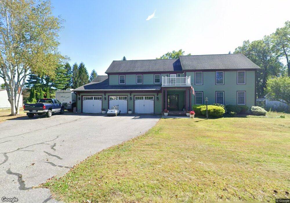
This home is located at 37 Front St, Leeds, MA 01053 and is currently estimated at $1,088,004, approximately $219 per square foot. 37 Front St is a home located in Hampshire County with nearby schools including Northampton High School, The Montessori School of Northampton, and Lander Grinspoon Academy.
Ownership History
Date
Name
Owned For
Owner Type
Purchase Details
Closed on
Oct 15, 1992
Sold by
Eastman Quentin B
Bought by
Jeffway Celesste R and Jeffway Robert W
Current Estimated Value
Home Financials for this Owner
Home Financials are based on the most recent Mortgage that was taken out on this home.
Original Mortgage
$160,000
Interest Rate
7.93%
Mortgage Type
Purchase Money Mortgage
Purchase Details
Closed on
Apr 30, 1990
Sold by
Kohl Benedict M
Bought by
Eastman Quentin B
Create a Home Valuation Report for This Property
The Home Valuation Report is an in-depth analysis detailing your home's value as well as a comparison with similar homes in the area
Home Values in the Area
Average Home Value in this Area
Purchase History
| Date | Buyer | Sale Price | Title Company |
|---|---|---|---|
| Jeffway Celesste R | $243,000 | -- | |
| Eastman Quentin B | $225,000 | -- |
Source: Public Records
Mortgage History
| Date | Status | Borrower | Loan Amount |
|---|---|---|---|
| Closed | Eastman Quentin B | $160,000 |
Source: Public Records
Tax History
| Year | Tax Paid | Tax Assessment Tax Assessment Total Assessment is a certain percentage of the fair market value that is determined by local assessors to be the total taxable value of land and additions on the property. | Land | Improvement |
|---|---|---|---|---|
| 2025 | $14,930 | $1,071,800 | $114,100 | $957,700 |
| 2024 | $15,049 | $990,700 | $108,900 | $881,800 |
| 2023 | $14,438 | $911,500 | $98,900 | $812,600 |
| 2022 | $12,641 | $706,600 | $92,700 | $613,900 |
| 2021 | $12,701 | $731,200 | $88,500 | $642,700 |
| 2020 | $12,284 | $731,200 | $88,500 | $642,700 |
| 2019 | $13,094 | $753,800 | $93,500 | $660,300 |
| 2018 | $12,705 | $745,600 | $93,500 | $652,100 |
| 2017 | $12,444 | $745,600 | $93,500 | $652,100 |
| 2016 | $12,049 | $745,600 | $93,500 | $652,100 |
| 2015 | $11,807 | $747,300 | $88,500 | $658,800 |
| 2014 | $11,501 | $747,300 | $88,500 | $658,800 |
Source: Public Records
Map
Nearby Homes
- 48 Evergreen Rd Unit 306
- 44 Evergreen Rd Unit 302
- 53 E Center St
- 139 Water St
- 0 Haydenville Rd
- 222 River Rd
- 214 Audubon Rd
- 3 Deer Haven Dr
- 2 Juniper Place
- 158 Main St
- 67 Park St Unit A
- 76 Maple St
- 17 Mountain St Unit B
- 42 Clark St
- 37 Landy Ave
- 296 Ryan Rd Unit A
- 296 Ryan Rd
- 296 Ryan Rd Unit B
- 575 Bridge Rd Unit 12-7
- 575 Bridge Rd Unit 10-5
- 33 Front St
- 47 Front St
- 59 Front St
- 44 Front St
- 5 Grove Ave
- 38 Front St
- 4 Villone Dr
- 50 Front St
- 1 Florence St Unit 7
- 1 Florence St Unit 6
- 1 Florence St Unit 5
- 1 Florence St Unit 4
- 1 Florence St Unit 3
- 1 Florence St Unit 2
- 1 Florence St
- 1 Florence St Unit 1
- 9 Grove St
- 0 Villone Dr
- 13 Grove Ave
- 58 Front St
Your Personal Tour Guide
Ask me questions while you tour the home.