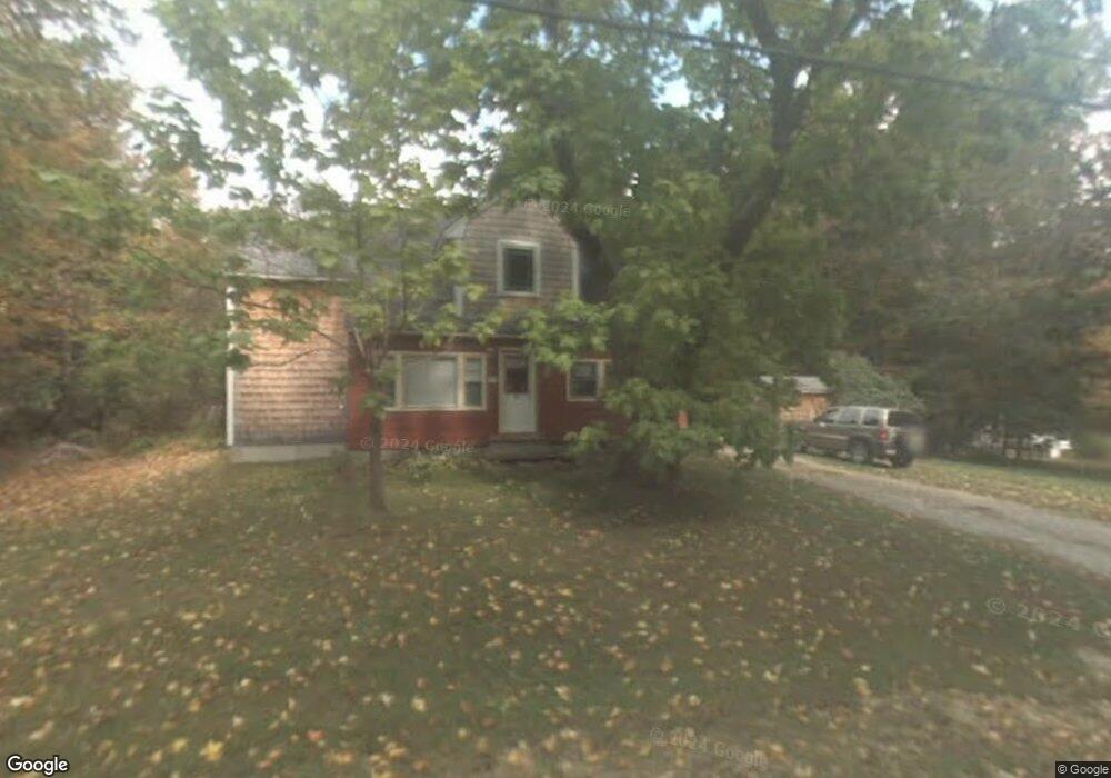
37 Gove Rd Deering, NH 03244
Estimated Value: $395,000 - $452,000
2
Beds
2
Baths
1,712
Sq Ft
$242/Sq Ft
Est. Value
About This Home
This home is located at 37 Gove Rd, Deering, NH 03244 and is currently estimated at $414,215, approximately $241 per square foot. 37 Gove Rd is a home located in Hillsborough County with nearby schools including Hillsboro-Deering Elementary School and Hillsboro-Deering High School.
Ownership History
Date
Name
Owned For
Owner Type
Purchase Details
Closed on
Jul 24, 2000
Sold by
Gove John C and Gove Helene
Bought by
Hupfer Brett L
Current Estimated Value
Home Financials for this Owner
Home Financials are based on the most recent Mortgage that was taken out on this home.
Original Mortgage
$69,800
Outstanding Balance
$25,065
Interest Rate
8.28%
Estimated Equity
$389,150
Create a Home Valuation Report for This Property
The Home Valuation Report is an in-depth analysis detailing your home's value as well as a comparison with similar homes in the area
Home Values in the Area
Average Home Value in this Area
Purchase History
| Date | Buyer | Sale Price | Title Company |
|---|---|---|---|
| Hupfer Brett L | $72,000 | -- |
Source: Public Records
Mortgage History
| Date | Status | Borrower | Loan Amount |
|---|---|---|---|
| Open | Hupfer Brett L | $20,200 | |
| Open | Hupfer Brett L | $69,800 |
Source: Public Records
Tax History Compared to Growth
Tax History
| Year | Tax Paid | Tax Assessment Tax Assessment Total Assessment is a certain percentage of the fair market value that is determined by local assessors to be the total taxable value of land and additions on the property. | Land | Improvement |
|---|---|---|---|---|
| 2024 | $6,199 | $220,600 | $64,500 | $156,100 |
| 2023 | $5,731 | $220,600 | $64,500 | $156,100 |
| 2022 | $5,019 | $220,600 | $64,500 | $156,100 |
| 2021 | $4,977 | $220,600 | $64,500 | $156,100 |
| 2020 | $5,473 | $220,600 | $64,500 | $156,100 |
| 2019 | $5,019 | $163,900 | $49,900 | $114,000 |
| 2018 | $73 | $163,100 | $49,900 | $113,200 |
| 2017 | $4,280 | $142,800 | $49,900 | $92,900 |
| 2016 | $64 | $137,100 | $49,900 | $87,200 |
| 2015 | $4,054 | $137,100 | $49,900 | $87,200 |
| 2014 | $3,686 | $149,400 | $59,700 | $89,700 |
| 2013 | $3,861 | $148,800 | $59,700 | $89,100 |
Source: Public Records
Map
Nearby Homes
- Lot 13 E Deering Rd
- 107 Branch Rd
- 30 Dels Way
- 62 Collins Landing Rd Unit 46
- 108 E Shore Dr
- 194 Buckley Rd Unit 2
- 194 Buckley Rd Unit 44
- 281 Hodgdon Rd
- 101-125 Winslow Rd
- 9 Reservoir Rd
- 126 Fisher Rd
- 92 Woodbury Rd
- 463 Craney Hill Rd
- 475 Old County Rd
- 10 Sap House Rd
- 200 Mountain Rd
- 11 White Birch Rd
- 586 C-4 Craney Hill Rd
- 196 Deering Center Rd
- 86 Manselville Rd
- 40 Gove Rd
- 43 Gove Rd
- 36 Gove Rd
- 66 Gove Rd
- 298 Abijah Bridge Rd
- 489 E Deering Rd
- 413 E Deering Rd
- 297 Abijah Bridge Rd
- 503 E Deering Rd
- 526 E Deering Rd
- 70 Gove Rd
- 465 E Deering Rd
- 260 Abijah Bridge Rd
- 446 E Deering Rd
- 533 E Deering Rd
- lot 12 E Deering Rd
- lot 15-1 E Deering Rd
- Lot 54 E Deering Rd
- 212-5 E Deering Rd
- 47 Dudley Brook Rd