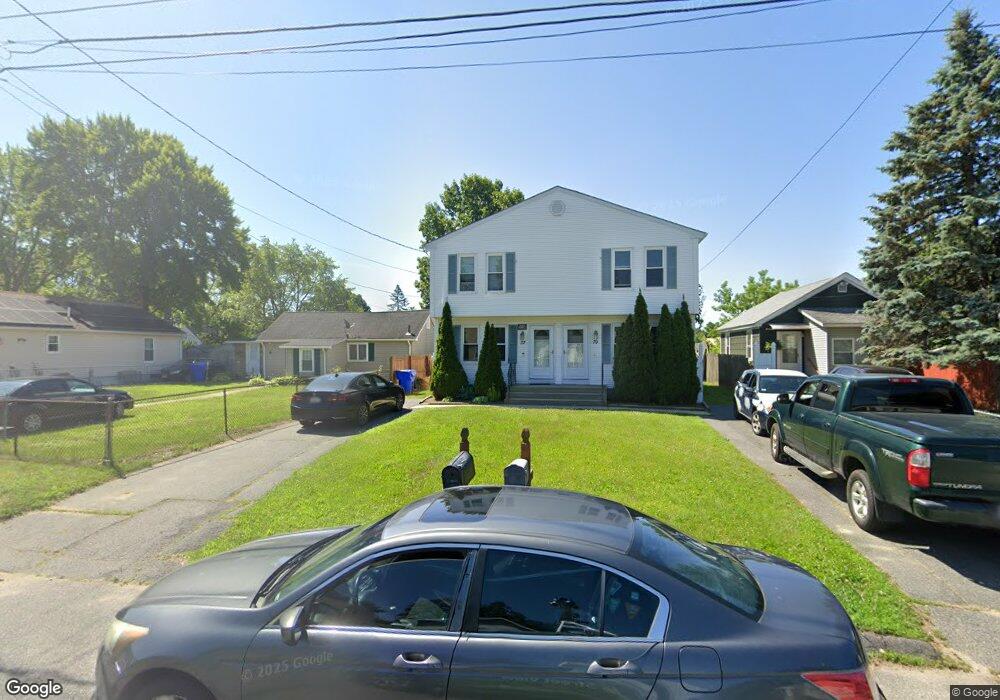
37 Newport St Unit 39 Springfield, MA 01119
Boston Road NeighborhoodEstimated Value: $373,000 - $434,000
6
Beds
4
Baths
2,240
Sq Ft
$177/Sq Ft
Est. Value
About This Home
This home is located at 37 Newport St Unit 39, Springfield, MA 01119 and is currently estimated at $395,418, approximately $176 per square foot. 37 Newport St Unit 39 is a home located in Hampden County with nearby schools including Frank H. Freedman School, John F. Kennedy Academy, and Springfield Central High School.
Ownership History
Date
Name
Owned For
Owner Type
Purchase Details
Closed on
Dec 30, 2009
Sold by
Ihedigbo Joy C
Bought by
Anderson Traceyann M
Current Estimated Value
Home Financials for this Owner
Home Financials are based on the most recent Mortgage that was taken out on this home.
Original Mortgage
$128,000
Outstanding Balance
$83,612
Interest Rate
4.85%
Mortgage Type
Purchase Money Mortgage
Estimated Equity
$311,806
Purchase Details
Closed on
May 13, 2005
Sold by
Thibault Rene R
Bought by
Ihedigbo Joy C
Home Financials for this Owner
Home Financials are based on the most recent Mortgage that was taken out on this home.
Original Mortgage
$214,700
Interest Rate
6.05%
Mortgage Type
Purchase Money Mortgage
Purchase Details
Closed on
Dec 14, 2004
Sold by
Loiko Edward L
Bought by
Thibault Rene R and Thibault Beatrice
Home Financials for this Owner
Home Financials are based on the most recent Mortgage that was taken out on this home.
Original Mortgage
$126,400
Interest Rate
5.63%
Mortgage Type
Purchase Money Mortgage
Purchase Details
Closed on
Mar 22, 2004
Sold by
Stone Anne M
Bought by
Loiko Edward L
Purchase Details
Closed on
Dec 6, 1995
Sold by
Handzel John M
Bought by
Stone Anne M
Home Financials for this Owner
Home Financials are based on the most recent Mortgage that was taken out on this home.
Original Mortgage
$71,175
Interest Rate
7.44%
Mortgage Type
Purchase Money Mortgage
Create a Home Valuation Report for This Property
The Home Valuation Report is an in-depth analysis detailing your home's value as well as a comparison with similar homes in the area
Home Values in the Area
Average Home Value in this Area
Purchase History
| Date | Buyer | Sale Price | Title Company |
|---|---|---|---|
| Anderson Traceyann M | $160,000 | -- | |
| Ihedigbo Joy C | $226,000 | -- | |
| Thibault Rene R | $158,000 | -- | |
| Loiko Edward L | -- | -- | |
| Stone Anne M | $94,900 | -- |
Source: Public Records
Mortgage History
| Date | Status | Borrower | Loan Amount |
|---|---|---|---|
| Open | Anderson Traceyann M | $128,000 | |
| Previous Owner | Ihedigbo Joy C | $214,700 | |
| Previous Owner | Thibault Rene R | $126,400 | |
| Previous Owner | Stone Anne M | $71,175 |
Source: Public Records
Tax History
| Year | Tax Paid | Tax Assessment Tax Assessment Total Assessment is a certain percentage of the fair market value that is determined by local assessors to be the total taxable value of land and additions on the property. | Land | Improvement |
|---|---|---|---|---|
| 2025 | $5,521 | $352,100 | $43,000 | $309,100 |
| 2024 | $5,057 | $314,900 | $40,200 | $274,700 |
| 2023 | $4,617 | $270,800 | $38,300 | $232,500 |
| 2022 | $4,233 | $224,900 | $38,300 | $186,600 |
| 2021 | $4,235 | $224,100 | $34,800 | $189,300 |
| 2020 | $4,133 | $211,600 | $34,800 | $176,800 |
| 2019 | $3,851 | $195,700 | $34,800 | $160,900 |
| 2018 | $3,476 | $189,200 | $34,800 | $154,400 |
| 2017 | $3,476 | $176,800 | $34,800 | $142,000 |
| 2016 | $3,376 | $171,700 | $34,800 | $136,900 |
| 2015 | $3,238 | $164,600 | $34,800 | $129,800 |
Source: Public Records
Map
Nearby Homes
Your Personal Tour Guide
Ask me questions while you tour the home.