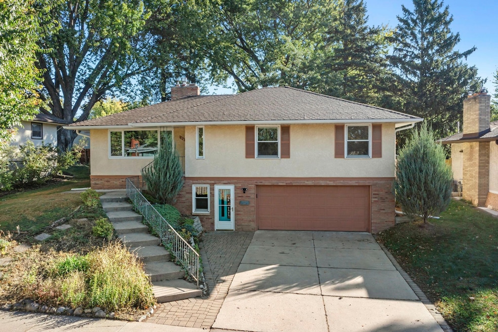
38 Morningside Dr Saint Paul, MN 55119
Battle Creek NeighborhoodEstimated payment $2,118/month
Highlights
- Family Room with Fireplace
- Double Oven
- 2 Car Attached Garage
- No HOA
- The kitchen features windows
- Patio
About This Home
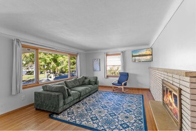
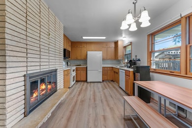
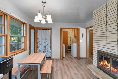
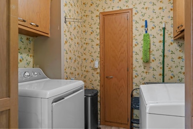
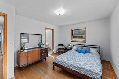
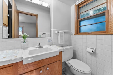
Ideally located near Battle Creek Elementary and beautiful Battle Creek Regional Park, this charming 3-bedroom, 3-bathroom home blends convenience, comfort, and character. Enjoy miles of nearby walking and biking trails, plus quick access to major roads for easy commutes. Step into the inviting living room with a large picture window, original hardwood floors, and a classic brick wood-burning fireplace. The newly remodeled kitchen (2024) features durable LVP flooring, fresh laminate countertops, stainless steel sink, new garbage disposal and dishwasher, plus a tile backsplash. A rare double-sided fireplace adds warmth to both the kitchen and living room. The connected dining area opens to the backyard, and a nearby laundry room with cabinetry and utility sink adds everyday ease. All three main-level bedrooms are well sized. The primary suite offers wood floors, multiple windows, and a private 3⁄4 ensuite with tile finishes. The additional bedrooms share a full bath with extended vanity space and hall closet storage. The walkout lower level offers a cozy family room with wood paneling, carpet, and a floor-to-ceiling gas fireplace. Counterspace is perfect for snacks or entertaining. A nearby 3⁄4 bath, multiple closets, utility room with sink and shelving, and direct access to the attached 2-car garage add function. Outside, enjoy a fenced yard with mature trees, large patio, fire pit area, garden space, and two fruit-producing grapevines. Fresh paint (2025), new gas dryer (2025), and new lower-level toilet (2024) make this home move-in ready.
Home Details
Home Type
- Single Family
Est. Annual Taxes
- $4,556
Year Built
- Built in 1963
Lot Details
- 7,187 Sq Ft Lot
- Wood Fence
- Chain Link Fence
- Irregular Lot
Parking
- 2 Car Attached Garage
- Garage Door Opener
Interior Spaces
- 1-Story Property
- Wood Burning Fireplace
- Two Way Fireplace
- Brick Fireplace
- Gas Fireplace
- Family Room with Fireplace
- 2 Fireplaces
- Living Room with Fireplace
- Dining Room
Kitchen
- Double Oven
- Range
- Microwave
- Dishwasher
- Disposal
- The kitchen features windows
Bedrooms and Bathrooms
- 3 Bedrooms
Laundry
- Laundry Room
- Dryer
- Washer
Finished Basement
- Walk-Out Basement
- Partial Basement
Utilities
- Forced Air Heating and Cooling System
- Humidifier
- Water Filtration System
- Gas Water Heater
Additional Features
- Air Exchanger
- Patio
Community Details
- No Home Owners Association
- Afton Heights Add Subdivision
Listing and Financial Details
- Assessor Parcel Number 022822410070
Map
Home Values in the Area
Average Home Value in this Area
Tax History
| Year | Tax Paid | Tax Assessment Tax Assessment Total Assessment is a certain percentage of the fair market value that is determined by local assessors to be the total taxable value of land and additions on the property. | Land | Improvement |
|---|---|---|---|---|
| 2025 | $4,286 | $287,700 | $35,100 | $252,600 |
| 2023 | $4,286 | $273,700 | $35,100 | $238,600 |
| 2022 | $4,076 | $265,200 | $35,100 | $230,100 |
| 2021 | $3,766 | $249,500 | $35,100 | $214,400 |
| 2020 | $3,902 | $238,500 | $35,100 | $203,400 |
| 2019 | $3,806 | $229,700 | $35,100 | $194,600 |
| 2018 | $3,750 | $220,500 | $35,100 | $185,400 |
| 2017 | $2,994 | $223,100 | $30,900 | $192,200 |
| 2016 | $2,750 | $0 | $0 | $0 |
| 2015 | $2,726 | $172,000 | $34,100 | $137,900 |
| 2014 | $2,880 | $0 | $0 | $0 |
Property History
| Date | Event | Price | List to Sale | Price per Sq Ft |
|---|---|---|---|---|
| 11/13/2025 11/13/25 | Pending | -- | -- | -- |
| 10/31/2025 10/31/25 | For Sale | $330,000 | 0.0% | $194 / Sq Ft |
| 10/29/2025 10/29/25 | Off Market | $330,000 | -- | -- |
| 10/16/2025 10/16/25 | For Sale | $330,000 | -- | $194 / Sq Ft |
Purchase History
| Date | Type | Sale Price | Title Company |
|---|---|---|---|
| Warranty Deed | -- | None Available |
Mortgage History
| Date | Status | Loan Amount | Loan Type |
|---|---|---|---|
| Open | $214,500 | VA |
Source: NorthstarMLS
MLS Number: 6802093
APN: 02-28-22-41-0070
Disclaimer: Certain information contained herein is derived from information provided by parties other than Homes.com. All information provided is deemed reliable, but is not guaranteed to be accurate and should be independently verified.
![]() Based on information submitted to the MLS GRID. All data is obtained from various sources and may not have been verified by broker or MLS GRID. Supplied Open House Information is subject to change without notice. All information should be independently reviewed and verified for accuracy. Properties may or may not be listed by the office/agent presenting the information. Some IDX listings have been excluded from this website.
Based on information submitted to the MLS GRID. All data is obtained from various sources and may not have been verified by broker or MLS GRID. Supplied Open House Information is subject to change without notice. All information should be independently reviewed and verified for accuracy. Properties may or may not be listed by the office/agent presenting the information. Some IDX listings have been excluded from this website.
The Digital Millennium Copyright Act of 1998, 17 U.S.C. § 512 (the “DMCA”) provides recourse for copyright owners who believe that material appearing on the Internet infringes their rights under U.S. copyright law. If you believe in good faith that any content or material made available in connection with our website or services infringes your copyright, you (or your agent) may send us a notice requesting that the content or material be removed, or access to it blocked.
Notices must be sent in writing by email to DMCAnotice@MLSGrid.com.
The DMCA requires that your notice of alleged copyright infringement include the following information:
(1) description of the copyrighted work that is the subject of claimed infringement;
(2) description of the alleged infringing content and information sufficient to permit us to locate the content;
(3) contact information for you, including your address, telephone number and email address;
(4) a statement by you that you have a good faith belief that the content in the manner complained of is not authorized by the copyright owner, or its agent, or by the operation of any law;
(5) a statement by you, signed under penalty of perjury, that the information in the notification is accurate and that you have the authority to enforce the copyrights that are claimed to be infringed; and
(6) a physical or electronic signature of the copyright owner or a person authorized to act on the copyright owner’s behalf. Failure to include all of the above information may result in the delay of the processing of your complaint.
- 2243 Edgebrook Ave
- 2169 Glenridge Ave
- 2063 N Park Dr Unit 6
- 125 Mcknight Rd N Unit K
- 2023 Parkside Dr
- 1989 N Park Dr
- 2226 Lower Afton Rd E
- 138 Ruth St N Unit 9
- 2445 Londin Ln E Unit 310
- 2445 Londin Ln E Unit 208
- 42 Oday St N
- 2365 Dorland Ln E Unit 62
- 371, 377, 381 Totem Rd
- 125 Battle Creek Place
- 2321 Pond Ave E Unit 36
- 2363 Dorland Ln E
- 2485 Londin Ln E Unit 418
- 2485 Londin Ln E Unit 323
- 1758 Grace Ln
- 1747 Louise Ave
