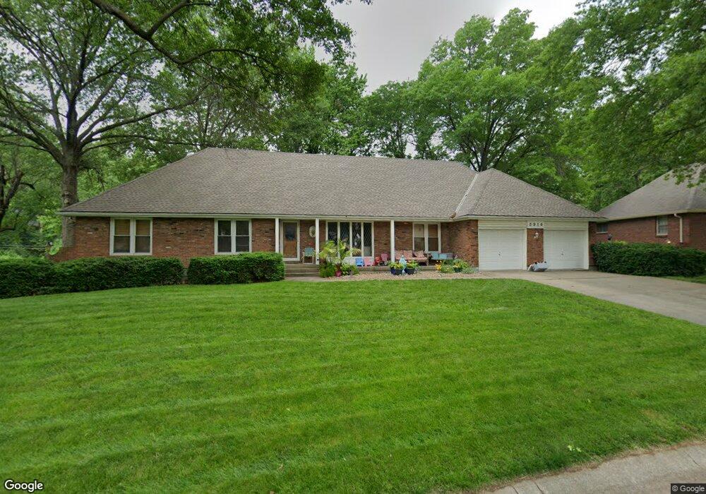
3916 S Sherman Dr Independence, MO 64055
Sycamore NeighborhoodEstimated Value: $243,000 - $277,000
3
Beds
2
Baths
1,693
Sq Ft
$153/Sq Ft
Est. Value
About This Home
This home is located at 3916 S Sherman Dr, Independence, MO 64055 and is currently estimated at $259,563, approximately $153 per square foot. 3916 S Sherman Dr is a home located in Jackson County with nearby schools including Sycamore Hills Elementary School, Bridger Middle School, and Pioneer Ridge Middle School.
Ownership History
Date
Name
Owned For
Owner Type
Purchase Details
Closed on
Mar 2, 1998
Sold by
Maynard Norman J and Maynard Virginia
Bought by
Trefz Gary M and Trefz Jill L
Current Estimated Value
Home Financials for this Owner
Home Financials are based on the most recent Mortgage that was taken out on this home.
Original Mortgage
$90,000
Outstanding Balance
$16,450
Interest Rate
7.01%
Mortgage Type
Purchase Money Mortgage
Estimated Equity
$243,113
Create a Home Valuation Report for This Property
The Home Valuation Report is an in-depth analysis detailing your home's value as well as a comparison with similar homes in the area
Home Values in the Area
Average Home Value in this Area
Purchase History
| Date | Buyer | Sale Price | Title Company |
|---|---|---|---|
| Trefz Gary M | -- | Stewart Title |
Source: Public Records
Mortgage History
| Date | Status | Borrower | Loan Amount |
|---|---|---|---|
| Open | Trefz Gary M | $90,000 |
Source: Public Records
Tax History Compared to Growth
Tax History
| Year | Tax Paid | Tax Assessment Tax Assessment Total Assessment is a certain percentage of the fair market value that is determined by local assessors to be the total taxable value of land and additions on the property. | Land | Improvement |
|---|---|---|---|---|
| 2025 | $2,786 | $41,828 | $5,394 | $36,434 |
| 2024 | $2,723 | $40,219 | $4,896 | $35,323 |
| 2023 | $2,723 | $40,219 | $4,260 | $35,959 |
| 2022 | $2,400 | $32,490 | $4,665 | $27,825 |
| 2021 | $2,399 | $32,490 | $4,665 | $27,825 |
| 2020 | $2,151 | $28,299 | $4,665 | $23,634 |
| 2019 | $2,116 | $28,299 | $4,665 | $23,634 |
| 2018 | $2,067 | $26,394 | $4,180 | $22,214 |
| 2017 | $2,067 | $26,394 | $4,180 | $22,214 |
| 2016 | $2,067 | $26,126 | $3,718 | $22,408 |
| 2014 | $1,963 | $25,365 | $3,610 | $21,755 |
Source: Public Records
Map
Nearby Homes
- 16002 E 41st St S
- 15415 E 41st St S
- 15405 E 40th St S
- 3813 Queen Ridge Dr
- 3830 S Summit Ridge Dr
- 15506 E 43rd Terrace S
- 15409 E 36th Terrace S
- 15606 E 36th St S
- 15307 E 43rd Terrace S
- 3920 S Milton Dr
- 3518 S Haden Dr
- 15711 E 44th Terrace S
- 16206 E 35th St S
- 4162 S Bryant Dr
- 16424 E George Franklyn Dr
- 3909 S Milton Dr
- 14805 E 40th St S
- 4217 E 42nd Street Way S
- 3506 S Haden Dr
- 15398 E 45th Place S
- 3916 S Sherman Dr
- 3912 S Breckenridge Dr
- 3921 S Breckenridge Dr
- 3917 S Breckenridge Dr
- 3921 S Sherman Dr
- 3913 S Breckenridge Dr
- 3917 S Sherman Dr
- 3923 S Breckenridge Dr
- 3908 S Breckenridge Dr
- 3913 S Sherman Dr
- 3909 S Breckenridge Dr
- 3928 S Sherman Dr
- 3909 S Sherman Dr
- 3924 S Sherman Dr
- 3904 S Breckenridge Dr
- 3932 S Sherman Dr
- 3912 S Sherman Dr
- 3905 S Breckenridge Dr
- 3916 S Grant Ave
- 3912 S Grant Ave