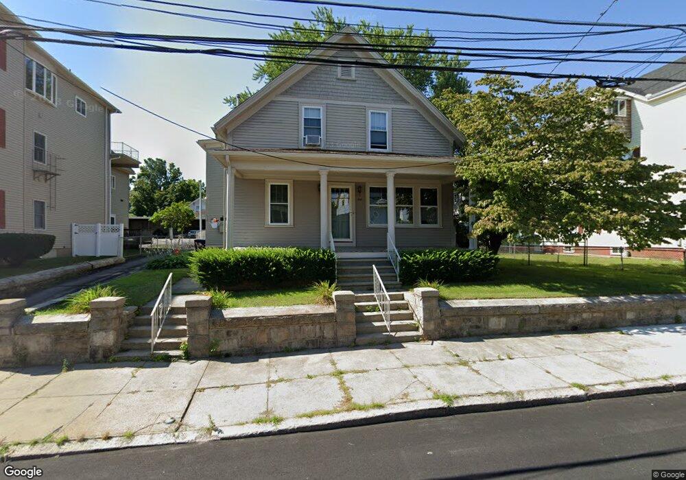
397 Carrington Ave Woonsocket, RI 02895
Bernon District NeighborhoodEstimated Value: $465,988 - $495,000
4
Beds
2
Baths
2,020
Sq Ft
$237/Sq Ft
Est. Value
About This Home
This home is located at 397 Carrington Ave, Woonsocket, RI 02895 and is currently estimated at $478,997, approximately $237 per square foot. 397 Carrington Ave is a home located in Providence County with nearby schools including Woonsocket High School, Rise Prep Mayoral Academy Middle School, and Founders Academy.
Ownership History
Date
Name
Owned For
Owner Type
Purchase Details
Closed on
Jul 30, 2025
Sold by
Cormier Phylis J Est and Cormier
Bought by
Lemay Michael
Current Estimated Value
Home Financials for this Owner
Home Financials are based on the most recent Mortgage that was taken out on this home.
Original Mortgage
$368,000
Outstanding Balance
$366,094
Interest Rate
6.81%
Mortgage Type
New Conventional
Estimated Equity
$112,903
Purchase Details
Closed on
Aug 17, 2009
Sold by
Jeanne Y Guertin T Y and Jeanne Cormier
Bought by
Cormier Phyllis J
Create a Home Valuation Report for This Property
The Home Valuation Report is an in-depth analysis detailing your home's value as well as a comparison with similar homes in the area
Home Values in the Area
Average Home Value in this Area
Purchase History
| Date | Buyer | Sale Price | Title Company |
|---|---|---|---|
| Lemay Michael | $460,000 | -- | |
| Lemay Michael | $460,000 | -- | |
| Cormier Phyllis J | -- | -- | |
| Cormier Phyllis J | -- | -- |
Source: Public Records
Mortgage History
| Date | Status | Borrower | Loan Amount |
|---|---|---|---|
| Open | Lemay Michael | $368,000 | |
| Closed | Lemay Michael | $368,000 |
Source: Public Records
Tax History
| Year | Tax Paid | Tax Assessment Tax Assessment Total Assessment is a certain percentage of the fair market value that is determined by local assessors to be the total taxable value of land and additions on the property. | Land | Improvement |
|---|---|---|---|---|
| 2025 | $4,503 | $401,000 | $90,700 | $310,300 |
| 2024 | $4,161 | $286,200 | $92,400 | $193,800 |
| 2023 | $4,001 | $286,200 | $92,400 | $193,800 |
| 2022 | $4,001 | $286,200 | $92,400 | $193,800 |
| 2021 | $3,589 | $151,100 | $37,700 | $113,400 |
| 2020 | $3,626 | $151,100 | $37,700 | $113,400 |
| 2018 | $3,638 | $151,100 | $37,700 | $113,400 |
| 2017 | $3,784 | $125,700 | $41,200 | $84,500 |
| 2016 | $4,002 | $125,700 | $41,200 | $84,500 |
| 2015 | $4,598 | $125,700 | $41,200 | $84,500 |
| 2014 | $3,872 | $118,400 | $45,400 | $73,000 |
Source: Public Records
Map
Nearby Homes
- 410 Carrington Ave
- 346 Carrington Ave
- 345 Carrington Ave
- 74 Maple St
- 18 Villa Nova St
- 24 Paradis Ave
- 526 Bernon St
- 233 Grove St
- 59 Division St
- 35 Greene St
- 372 Cumberland Hill Rd
- 56 Mailloux St
- 190 Crawford St
- 271 Elm St
- 311 Elm St
- 263 Elm St
- 219 Crawford St
- 40 Burnside Ave
- 34 Heroux Ave
- 180 Allen St Unit 104
- 397 Carrington Ave Unit 397 Carrington ave.
- 383 Carrington Ave
- 409 Carrington Ave
- 113 Bennett St
- 125 Bennett St
- 127 Bennett St
- 133 Bennett St
- 37 Roberts St
- 25 Roberts St Unit 1 & 2
- 25 Roberts St Unit 3
- 25 Roberts St Unit 2
- 25 Roberts St Unit 1
- 25 Roberts St Unit 4
- 25 Roberts St
- 380 Carrington Ave
- 380 Carrington Ave Unit 2
- 429 Carrington Ave
- 429 Carrington Ave Unit 3
- 429 Carrington Ave Unit 2
- 429 Carrington Ave Unit 1
Your Personal Tour Guide
Ask me questions while you tour the home.