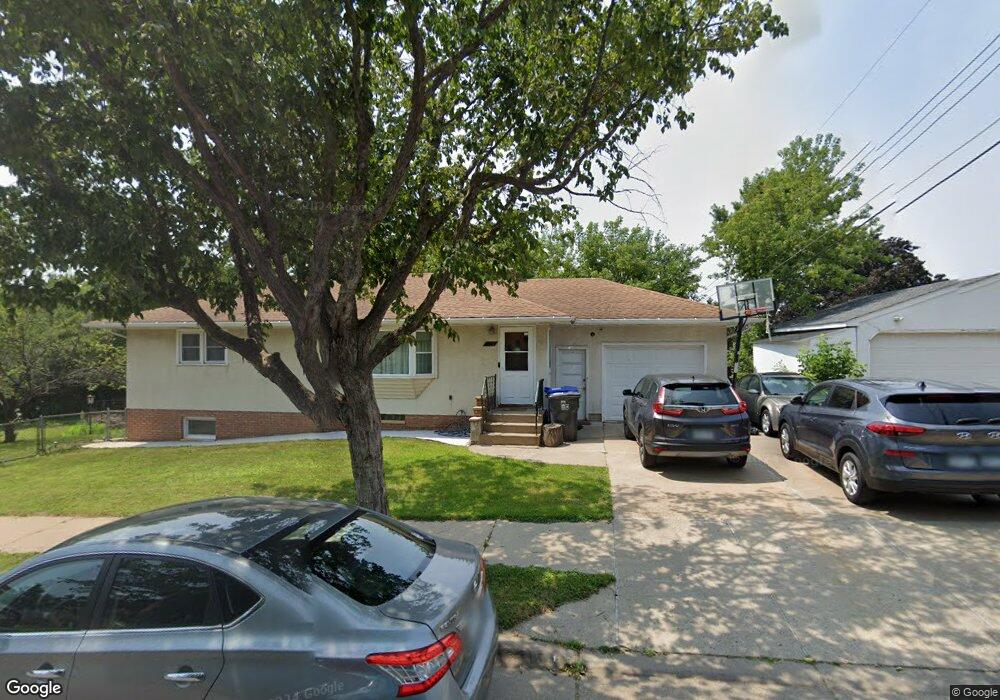
397 Kennard St Saint Paul, MN 55106
Battle Creek NeighborhoodEstimated Value: $287,000 - $315,000
4
Beds
2
Baths
2,200
Sq Ft
$137/Sq Ft
Est. Value
About This Home
This home is located at 397 Kennard St, Saint Paul, MN 55106 and is currently estimated at $301,939, approximately $137 per square foot. 397 Kennard St is a home located in Ramsey County with nearby schools including Battle Creek Elementary School, Battle Creek Middle School, and Harding Senior High School.
Ownership History
Date
Name
Owned For
Owner Type
Purchase Details
Closed on
Nov 10, 2021
Sold by
Moua Tong
Bought by
Fungafatt Deneca V
Current Estimated Value
Home Financials for this Owner
Home Financials are based on the most recent Mortgage that was taken out on this home.
Original Mortgage
$247,350
Outstanding Balance
$226,717
Interest Rate
3.01%
Mortgage Type
New Conventional
Estimated Equity
$75,223
Purchase Details
Closed on
Apr 13, 2011
Sold by
Federal National Mortgage Association
Bought by
Moua Tong
Purchase Details
Closed on
Oct 1, 1998
Sold by
Estate Of Darline D Eastman
Bought by
Francisco Virgilio and Francisco Lolita A
Create a Home Valuation Report for This Property
The Home Valuation Report is an in-depth analysis detailing your home's value as well as a comparison with similar homes in the area
Home Values in the Area
Average Home Value in this Area
Purchase History
| Date | Buyer | Sale Price | Title Company |
|---|---|---|---|
| Fungafatt Deneca V | $255,000 | Titlesmart Inc | |
| Moua Tong | $85,000 | -- | |
| Francisco Virgilio | $90,000 | -- |
Source: Public Records
Mortgage History
| Date | Status | Borrower | Loan Amount |
|---|---|---|---|
| Open | Fungafatt Deneca V | $247,350 |
Source: Public Records
Tax History Compared to Growth
Tax History
| Year | Tax Paid | Tax Assessment Tax Assessment Total Assessment is a certain percentage of the fair market value that is determined by local assessors to be the total taxable value of land and additions on the property. | Land | Improvement |
|---|---|---|---|---|
| 2025 | $3,484 | $278,300 | $45,900 | $232,400 |
| 2023 | $3,484 | $227,600 | $28,600 | $199,000 |
| 2022 | $3,172 | $238,100 | $28,600 | $209,500 |
| 2021 | $2,872 | $209,100 | $28,600 | $180,500 |
| 2020 | $2,996 | $186,500 | $28,600 | $157,900 |
| 2019 | $2,564 | $182,400 | $28,600 | $153,800 |
| 2018 | $2,104 | $156,100 | $28,600 | $127,500 |
| 2017 | $2,056 | $139,800 | $28,600 | $111,200 |
| 2016 | $1,970 | $0 | $0 | $0 |
| 2015 | $1,862 | $132,000 | $28,600 | $103,400 |
| 2014 | $1,644 | $0 | $0 | $0 |
Source: Public Records
Map
Nearby Homes
- 1600 Old Hudson Rd
- 1538 Wilson Ave
- 267 Hazelwood St
- 1685 Fremont Ave
- 1821 Wilson Ave
- 1443 Pacific St
- 237 Sigurd St
- 1450 Fremont Ave
- 201 Dora Ct W
- 1489 6th St E
- 1551 Margaret St
- 1751 Margaret St
- 1333 Pacific St
- 1351 3rd St E
- 1493 Margaret St
- 1320 Wilson Ave
- 1590 Minnehaha Ave E
- 244 Point Douglas Rd N
- 125 Battle Creek Place
- 1935 Fremont Ave E
- 1655 Old Hudson Rd
- 1655 1655 Old Hudson Rd
- 1656 Wilson Ave
- 1650 Wilson Ave
- 1662 Wilson Ave
- 1644 Wilson Ave
- 386 Kennard St
- 398 Kennard St
- 394 Kennard St
- 1639 Old Hudson Rd
- 1639 1639 Old Hudson Rd
- 1639 1639 Old Hudson-Road-
- 1668 Wilson Ave
- 1638 Wilson Ave
- 1669 1669 Old Hudson Rd
- 1669 Old Hudson Rd
- 1637 Old Hudson Rd
- 1637 1637 Old Hudson Rd
- 1672 Wilson Ave
- 1675 Old Hudson Rd