Estimated Value: $709,000 - $778,000
4
Beds
3
Baths
2,542
Sq Ft
$289/Sq Ft
Est. Value
About This Home
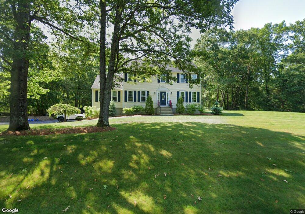
This home is located at 4 Montgomery Farm Rd, Derry, NH 03038 and is currently estimated at $735,083, approximately $289 per square foot. 4 Montgomery Farm Rd is a home located in Rockingham County with nearby schools including South Range Elementary School, West Running Brook Middle School, and Pinkerton Academy.
Ownership History
Date
Name
Owned For
Owner Type
Purchase Details
Closed on
Mar 17, 2022
Sold by
Pierni Michael A and Pierni Caren A
Bought by
Pierni Brian J and Noyes Casey J
Current Estimated Value
Home Financials for this Owner
Home Financials are based on the most recent Mortgage that was taken out on this home.
Original Mortgage
$488,700
Outstanding Balance
$456,235
Interest Rate
4.16%
Mortgage Type
Purchase Money Mortgage
Estimated Equity
$278,848
Create a Home Valuation Report for This Property
The Home Valuation Report is an in-depth analysis detailing your home's value as well as a comparison with similar homes in the area
Home Values in the Area
Average Home Value in this Area
Purchase History
| Date | Buyer | Sale Price | Title Company |
|---|---|---|---|
| Pierni Brian J | $543,000 | None Available | |
| Pierni Brian J | $543,000 | None Available |
Source: Public Records
Mortgage History
| Date | Status | Borrower | Loan Amount |
|---|---|---|---|
| Open | Pierni Brian J | $488,700 | |
| Closed | Pierni Brian J | $488,700 |
Source: Public Records
Tax History Compared to Growth
Tax History
| Year | Tax Paid | Tax Assessment Tax Assessment Total Assessment is a certain percentage of the fair market value that is determined by local assessors to be the total taxable value of land and additions on the property. | Land | Improvement |
|---|---|---|---|---|
| 2024 | $12,027 | $643,500 | $223,800 | $419,700 |
| 2023 | $11,469 | $554,600 | $190,200 | $364,400 |
| 2022 | $10,560 | $554,600 | $190,200 | $364,400 |
| 2021 | $10,043 | $405,600 | $146,100 | $259,500 |
| 2020 | $9,872 | $405,600 | $146,100 | $259,500 |
| 2019 | $9,213 | $352,700 | $103,500 | $249,200 |
| 2018 | $9,571 | $352,700 | $103,500 | $249,200 |
| 2017 | $8,741 | $321,600 | $93,500 | $228,100 |
| 2016 | $8,702 | $321,600 | $93,500 | $228,100 |
| 2015 | $8,418 | $288,000 | $93,500 | $194,500 |
| 2014 | $8,473 | $288,000 | $93,500 | $194,500 |
| 2013 | $8,430 | $267,700 | $88,500 | $179,200 |
Source: Public Records
Map
Nearby Homes
- 13 Gamache Rd
- 66 Derryfield Rd Unit L
- 90L Derryfield Rd
- 90L Derryfield Rd Unit L
- 1 Joan St
- 83 Beech Terrace
- 24 Sheffield Way
- 30 Kendall Pond Rd Unit 77
- 30 Kendall Pond Rd Unit 87
- 7 Oakwood St
- 13 Tiger Tail Cir
- 65 Fordway Extension Unit 211
- 2 Brown Rd
- 3 Elise Ave Unit 95
- 12 Morrison Dr
- 12 Elise Ave Unit 6
- 14 Elise Ave Unit 7
- 149 Londonderry Rd
- 5 Elise Ave Unit Lot 94
- 14 Reed St
- 6 Montgomery Farm Rd
- 2 Montgomery Farm Rd
- 3 Montgomery Farm Rd
- 137 Fordway Extension
- 5 Montgomery Farm Rd
- 141 Fordway Extension
- 1 Montgomery Farm Rd
- 1 Beacon Hill Rd
- 145 Fordway Extension
- 142 Fordway Extension
- 129 Fordway Extension
- 132 Fordway Extension
- 134 Fordway Extension
- 148 Fordway Extension
- 136 Fordway Extension
- 130 Fordway Extension
- 2B Beacon Hill Rd
- 2 Beacon Hill Rd
- 147 Fordway Extension
- 119 Fordway Extension