Estimated Value: $434,000 - $510,000
3
Beds
2
Baths
1,332
Sq Ft
$349/Sq Ft
Est. Value
About This Home
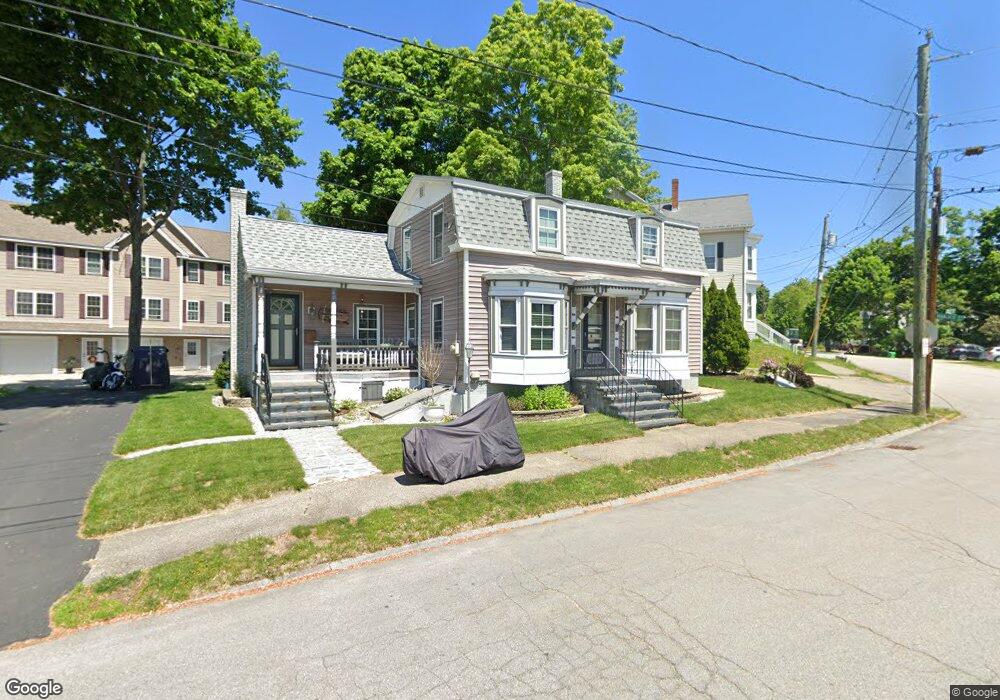
This home is located at 40 Forest St, Dover, NH 03820 and is currently estimated at $464,935, approximately $349 per square foot. 40 Forest St is a home located in Strafford County with nearby schools including Horne Street School, Dover Middle School, and Dover Senior High School.
Ownership History
Date
Name
Owned For
Owner Type
Purchase Details
Closed on
Dec 29, 2000
Sold by
Morning Glory Ests Mgt
Bought by
Lebrasseur James D
Current Estimated Value
Home Financials for this Owner
Home Financials are based on the most recent Mortgage that was taken out on this home.
Original Mortgage
$76,500
Interest Rate
7.7%
Create a Home Valuation Report for This Property
The Home Valuation Report is an in-depth analysis detailing your home's value as well as a comparison with similar homes in the area
Home Values in the Area
Average Home Value in this Area
Purchase History
| Date | Buyer | Sale Price | Title Company |
|---|---|---|---|
| Lebrasseur James D | $75,000 | -- |
Source: Public Records
Mortgage History
| Date | Status | Borrower | Loan Amount |
|---|---|---|---|
| Open | Lebrasseur James D | $227,200 | |
| Closed | Lebrasseur James D | $66,500 | |
| Closed | Lebrasseur James D | $76,500 |
Source: Public Records
Tax History
| Year | Tax Paid | Tax Assessment Tax Assessment Total Assessment is a certain percentage of the fair market value that is determined by local assessors to be the total taxable value of land and additions on the property. | Land | Improvement |
|---|---|---|---|---|
| 2024 | $7,435 | $409,200 | $169,400 | $239,800 |
| 2023 | $6,674 | $356,900 | $146,300 | $210,600 |
| 2022 | $6,515 | $328,400 | $138,600 | $189,800 |
| 2021 | $6,378 | $293,900 | $129,200 | $164,700 |
| 2020 | $6,001 | $241,500 | $106,300 | $135,200 |
| 2019 | $5,728 | $227,400 | $94,900 | $132,500 |
| 2018 | $5,762 | $231,200 | $102,500 | $128,700 |
| 2017 | $5,495 | $212,400 | $87,300 | $125,100 |
| 2016 | $5,103 | $194,100 | $80,700 | $113,400 |
| 2015 | $4,992 | $187,600 | $76,700 | $110,900 |
| 2014 | $4,879 | $187,600 | $76,700 | $110,900 |
| 2011 | $4,399 | $175,100 | $72,700 | $102,400 |
Source: Public Records
Map
Nearby Homes
- 46-50 Cocheco St
- 00 Granite St Unit 46-1
- 6 Granite St
- 3 Cocheco St
- 47 Central Ave
- 22 Little Bay Dr
- 24 Little Bay Dr
- 34 Floral Ave Unit 5
- 226 Oak St
- Lot 1 Emerson Ridge Unit 1
- Lot 2 Emerson Ridge Unit 2
- 43 Sixth St Unit A and B
- Lot 6 Emerson Ridge Unit 6
- Lot 3 Enclave Unit 13F-2
- 725 Central Ave Unit 203
- 725 Central Ave Unit LL03
- 725 Central Ave Unit 301
- 725 Central Ave Unit 302
- 725 Central Ave Unit LL01
- 725 Central Ave Unit 304
- 3 Waverly Drive Unit #3 Unit 3
- 3 Waverly Dr Unit 3
- 2 Waverly Dr Unit 2
- 45 Forest St
- 43 Forest St
- 43 Forest St
- 46 Forest St
- 47 Forest St
- 9 Hancock St
- 43 1/2 Forest St
- 43.5 Forest St
- 43 Forest St
- 7 Hancock St
- 37 & 39 Forest St
- 50 Forest St
- 41 Forest St
- 1 Waverly Dr Unit 1
- 4 Waverly Dr Unit 4
- 37 39 Forest Unit 24-83
- 49 Forest St
Your Personal Tour Guide
Ask me questions while you tour the home.