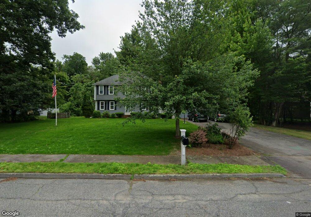
41 Windchime Dr Mansfield, MA 02048
Estimated Value: $788,004 - $962,000
4
Beds
3
Baths
1,950
Sq Ft
$449/Sq Ft
Est. Value
About This Home
This home is located at 41 Windchime Dr, Mansfield, MA 02048 and is currently estimated at $875,751, approximately $449 per square foot. 41 Windchime Dr is a home located in Bristol County with nearby schools including Jordan/Jackson Elementary School, Everett W. Robinson Elementary School, and Harold L. Qualters Middle School.
Ownership History
Date
Name
Owned For
Owner Type
Purchase Details
Closed on
May 1, 2003
Sold by
Sylvester Benjamin F and Sylvester Heidi L
Bought by
Knight Linda E and Knight Michael P
Current Estimated Value
Home Financials for this Owner
Home Financials are based on the most recent Mortgage that was taken out on this home.
Original Mortgage
$322,700
Outstanding Balance
$140,558
Interest Rate
5.82%
Mortgage Type
Purchase Money Mortgage
Estimated Equity
$735,193
Purchase Details
Closed on
Aug 7, 2001
Sold by
Keady James D and Keady Sheryl A
Bought by
Sylvester Benjamin and Sylvester Heidi L
Purchase Details
Closed on
Jul 1, 1987
Sold by
Kelliher Brian J
Bought by
Keady James D
Create a Home Valuation Report for This Property
The Home Valuation Report is an in-depth analysis detailing your home's value as well as a comparison with similar homes in the area
Home Values in the Area
Average Home Value in this Area
Purchase History
| Date | Buyer | Sale Price | Title Company |
|---|---|---|---|
| Knight Linda E | $462,375 | -- | |
| Sylvester Benjamin | $358,000 | -- | |
| Keady James D | $228,000 | -- |
Source: Public Records
Mortgage History
| Date | Status | Borrower | Loan Amount |
|---|---|---|---|
| Open | Knight Linda E | $322,700 | |
| Previous Owner | Keady James D | $285,000 | |
| Previous Owner | Keady James D | $40,100 |
Source: Public Records
Tax History
| Year | Tax Paid | Tax Assessment Tax Assessment Total Assessment is a certain percentage of the fair market value that is determined by local assessors to be the total taxable value of land and additions on the property. | Land | Improvement |
|---|---|---|---|---|
| 2025 | $8,937 | $678,600 | $283,400 | $395,200 |
| 2024 | $8,878 | $657,600 | $295,800 | $361,800 |
| 2023 | $8,620 | $611,800 | $295,800 | $316,000 |
| 2022 | $8,301 | $547,200 | $273,800 | $273,400 |
| 2021 | $8,059 | $524,700 | $228,200 | $296,500 |
| 2020 | $7,940 | $516,900 | $228,200 | $288,700 |
| 2019 | $7,327 | $481,400 | $190,100 | $291,300 |
| 2018 | $2,475 | $467,300 | $181,300 | $286,000 |
| 2017 | $6,825 | $454,400 | $176,200 | $278,200 |
| 2016 | $6,549 | $425,000 | $167,700 | $257,300 |
| 2015 | $6,384 | $411,900 | $167,700 | $244,200 |
Source: Public Records
Map
Nearby Homes
- 14 Windchime Dr
- 1 Deer Path Ln
- 7 Fieldstone Dr
- 212 Mill St
- 19 Barberry Rd
- 16 Holly Rd
- 0 Kensington Rd
- 21 Juniper Rd
- 0 Knollwood & 0 Rear Kensington
- 0 Cobb St
- 0 Brook Pkwy
- 631 East St Unit L101
- 97 East St
- 46 Hope St
- 1 Wilbur Terrace Unit 6
- 1 Wilbur Terrace Unit 2
- 2 N Main St Unit B201
- 4 Erick Rd Unit 90
- 46 Newland St
- 122 Samoset Ave
Your Personal Tour Guide
Ask me questions while you tour the home.