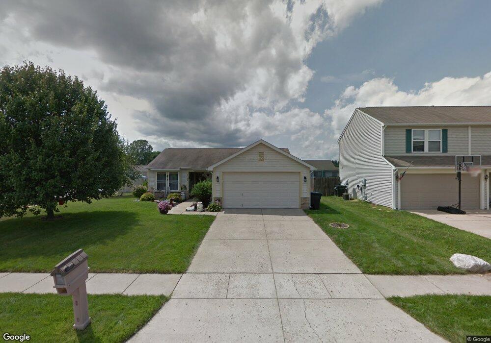
4142 Calder Dr Lafayette, IN 47909
Estimated Value: $232,140 - $245,000
--
Bed
--
Bath
1,072
Sq Ft
$222/Sq Ft
Est. Value
About This Home
This home is located at 4142 Calder Dr, Lafayette, IN 47909 and is currently estimated at $237,785, approximately $221 per square foot. 4142 Calder Dr is a home located in Tippecanoe County with nearby schools including Wea Ridge Elementary School, Wea Ridge Middle School, and McCutcheon High School.
Ownership History
Date
Name
Owned For
Owner Type
Purchase Details
Closed on
Oct 17, 2003
Sold by
Hud
Bought by
Bending George
Current Estimated Value
Home Financials for this Owner
Home Financials are based on the most recent Mortgage that was taken out on this home.
Original Mortgage
$86,000
Outstanding Balance
$44,307
Interest Rate
7.75%
Mortgage Type
Unknown
Estimated Equity
$193,478
Purchase Details
Closed on
Aug 12, 2003
Sold by
Washington Mutual Bank Fa
Bought by
Hud
Purchase Details
Closed on
Jun 3, 2003
Sold by
Turpin Bryan J and Turpin Jessica C
Bought by
Washington Mutual Bank Fa
Create a Home Valuation Report for This Property
The Home Valuation Report is an in-depth analysis detailing your home's value as well as a comparison with similar homes in the area
Home Values in the Area
Average Home Value in this Area
Purchase History
| Date | Buyer | Sale Price | Title Company |
|---|---|---|---|
| Bending George | -- | -- | |
| Hud | -- | -- | |
| Washington Mutual Bank Fa | $116,292 | -- |
Source: Public Records
Mortgage History
| Date | Status | Borrower | Loan Amount |
|---|---|---|---|
| Open | Bending George | $86,000 |
Source: Public Records
Tax History Compared to Growth
Tax History
| Year | Tax Paid | Tax Assessment Tax Assessment Total Assessment is a certain percentage of the fair market value that is determined by local assessors to be the total taxable value of land and additions on the property. | Land | Improvement |
|---|---|---|---|---|
| 2024 | $1,661 | $170,400 | $16,000 | $154,400 |
| 2023 | $1,448 | $156,900 | $16,000 | $140,900 |
| 2022 | $1,354 | $135,400 | $16,000 | $119,400 |
| 2021 | $1,109 | $117,700 | $16,000 | $101,700 |
| 2020 | $956 | $109,600 | $16,000 | $93,600 |
| 2019 | $859 | $103,600 | $16,000 | $87,600 |
| 2018 | $788 | $100,100 | $16,000 | $84,100 |
| 2017 | $741 | $96,000 | $16,000 | $80,000 |
| 2016 | $702 | $94,800 | $16,000 | $78,800 |
| 2014 | $634 | $91,400 | $16,000 | $75,400 |
| 2013 | $550 | $84,500 | $12,000 | $72,500 |
Source: Public Records
Map
Nearby Homes
- 920 N Wagon Wheel Trail
- 4101 Lofton Dr
- 934 Ravenstone Dr
- 8151 John Adams Rd
- 8165 John Adams Rd
- 8171 John Adams Rd
- 8157 John Adams Rd
- TBD John Adams Rd
- 3906 John Adams Rd
- 1120 Stoneripple Cir
- 1007 Waterstone Dr
- 1821 Whisper Valley Dr
- 214 Mccutcheon Dr
- 1817 Kingfisher Dr
- 4945 S 100 E
- 51 Brookberry Dr
- 936 Brookridge Ct
- 90 Mayflower Ct
- 12 Brookhill Ct
- 1554 Keystone Ct