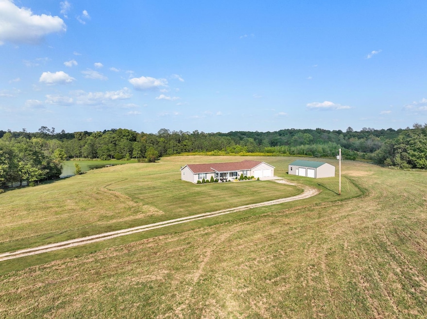
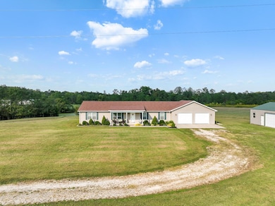
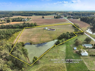
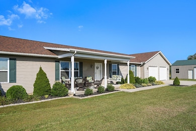
4146 Milton Bearbranch Rd Dillsboro, IN 47018
Estimated payment $2,968/month
Highlights
- Lake View
- Wooded Lot
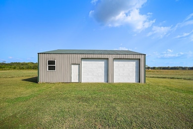
- Pole Barn
- 13.71 Acre Lot
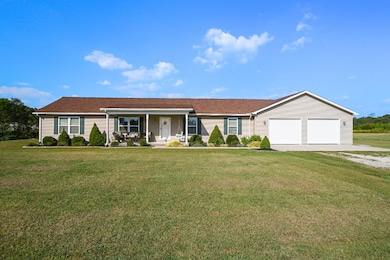
- Ranch Style House
- 2 Car Garage
About This Home
Trade the noise of the city for the sound of nature at 4146 Milton Bear Branch Rd. Set on 13.71 acres in Ohio County, this 2017 modular home offers 3BR/2BA and 1,792 sq ft of living space, a 30x30 attached garage, 30x40 pole barn with electric, concrete floor, and workshop, plus a 1-acre stocked lake. An additional 4.02-acre tract is includedideal to build another home or hold as an investment. The land offers open pasture that lays perfectly for future horse facilities, areas of woods that draw abundant wildlife, and room for recreation, gardening, or small farming. Inside, the home has an inviting open floor plan where the living, dining, kitchen, and family rooms flow together, creating generous space for gatherings. The split bedroom layout features a private master suite with large bath and walk-in closet, while two additional spacious bedrooms share a full bath on the opposite side. Comfort inside, adventure outsideyour country lifestyle awaits.
Property Details
Home Type
- Modular Prefabricated Home
Est. Annual Taxes
- $2,414
Year Built
- Built in 2017
Lot Details
- 13.71 Acre Lot
- Level Lot
- Wooded Lot
Parking
- 2 Car Garage
- Oversized Parking
- Workshop in Garage
- Front Facing Garage
- Gravel Driveway
- Off-Street Parking
Property Views
- Lake
- Woods
- Valley
Home Design
- Single Family Detached Home
- Ranch Style House
- Modular Prefabricated Home
- Poured Concrete
- Fire Rated Drywall
- Shingle Roof
- Vinyl Siding
Interior Spaces
- 1,792 Sq Ft Home
- Ceiling Fan
- Vinyl Clad Windows
- Family Room
- Dining Room
Kitchen
- Oven or Range
- Dishwasher
- Kitchen Island
Flooring
- Wall to Wall Carpet
- Vinyl
Bedrooms and Bathrooms
- 3 Bedrooms
- En-Suite Primary Bedroom
- 2 Full Bathrooms
- Shower Only
Laundry
- Laundry on main level
- Dryer
- Washer
Outdoor Features
- Pole Barn
- Porch
Farming
- 8 Acres of Pasture
- Pasture
Utilities
- Central Air
- Heat Pump System
- Natural Gas Not Available
- Electric Water Heater
- Water Softener
- Septic Tank
Community Details
- Southeastern Indiana Board Association
- Cedar Hollow Subdivision
Listing and Financial Details
- Homestead Exemption
- Tax Lot 6 & 7
- Assessor Parcel Number 0020411400001006
Map
Home Values in the Area
Average Home Value in this Area
Tax History
| Year | Tax Paid | Tax Assessment Tax Assessment Total Assessment is a certain percentage of the fair market value that is determined by local assessors to be the total taxable value of land and additions on the property. | Land | Improvement |
|---|---|---|---|---|
| 2024 | $2,414 | $288,200 | $46,200 | $242,000 |
| 2023 | $2,254 | $261,800 | $43,700 | $218,100 |
| 2022 | $1,841 | $238,100 | $39,700 | $198,400 |
| 2021 | $1,958 | $217,800 | $35,900 | $181,900 |
| 2020 | $1,649 | $188,100 | $35,800 | $152,300 |
| 2019 | $1,564 | $181,400 | $33,600 | $147,800 |
| 2018 | $1,506 | $175,100 | $33,900 | $141,200 |
| 2017 | $205 | $12,800 | $12,800 | $0 |
| 2016 | $218 | $13,600 | $13,600 | $0 |
| 2014 | $155 | $14,100 | $14,100 | $0 |
| 2013 | $116 | $12,200 | $12,200 | $0 |
Property History
| Date | Event | Price | List to Sale | Price per Sq Ft |
|---|---|---|---|---|
| 09/29/2025 09/29/25 | For Sale | $524,900 | -- | $293 / Sq Ft |
Purchase History
| Date | Type | Sale Price | Title Company |
|---|---|---|---|
| Warranty Deed | $46,500 | Attorney | |
| Corporate Deed | -- | -- |
Mortgage History
| Date | Status | Loan Amount | Loan Type |
|---|---|---|---|
| Open | $216,021 | New Conventional |
Source: Southeastern Indiana Board of REALTORS®
MLS Number: 206037
APN: 58-04-11-400-001.006-002
Disclaimer: Certain information contained herein is derived from information provided by parties other than Homes.com. All information provided is deemed reliable, but is not guaranteed to be accurate and should be independently verified.
![]() IDX information is provided exclusively for personal, non-commercial use, and may not be used for any purpose other than to identify prospective properties consumers may be interested in purchasing. Information is deemed reliable but not guaranteed.
IDX information is provided exclusively for personal, non-commercial use, and may not be used for any purpose other than to identify prospective properties consumers may be interested in purchasing. Information is deemed reliable but not guaranteed.
- 2871 Mexico Ridge Rd
- 15407 Aberdeen Rd
- 6834 Althoff Rd
- 14071 Goodner Rd
- 14072 Upper Tinker Rd
- 10625 In-262
- 10468 Indiana 262
- 0 Indiana 250
- 0 S Co Road 575 E
- S Cr 575 E
- 1741 Indiana 250
- 8360 Bocock Rd
- 14134 Sangamaw Rd
- 5900 S Co Road 700 E
- 9480 Stoops Rd
- 9463 Stoops Rd
- 12244 Lake Geneva Rd
- 10625 St Rd 262
- 7788 White Rd
- 12459 North St
- 9920 State Road 262
- 109 Dewers St
- 14633 Indiana 350 Unit 45
- 305 W Seminary St
- 102 Gaslight Dr Unit 64
- 204 Riverview Dr Unit 2
- 200 Riverview Dr
- 100 River Rd
- 1216 Meadow Creek Ln
- 157 Wideview Dr
- 500 W High St
- 115 Kansas St
- 35 E High St Unit 1 Lower
- 6158 Antique Ct
- 6000-6088 S Pointe Dr
- 1448 Cliftmont Cir
- 1753 Cove Cir E
- 3078 Cattail Cove Ln
- 6486-6492 Rosetta Dr
- 8423 Old World Ct
