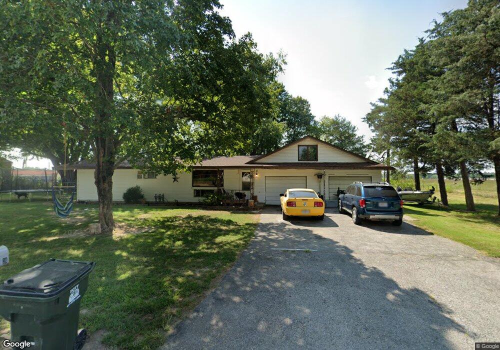
415 Wolfe Rd Aurora, MO 65605
Estimated Value: $193,169 - $230,000
3
Beds
1
Bath
1,847
Sq Ft
$115/Sq Ft
Est. Value
About This Home
This home is located at 415 Wolfe Rd, Aurora, MO 65605 and is currently estimated at $213,292, approximately $115 per square foot. 415 Wolfe Rd is a home with nearby schools including Pate Early Childhood Center, Robinson Intermediate School, and Robinson Elementary School.
Ownership History
Date
Name
Owned For
Owner Type
Purchase Details
Closed on
Jun 21, 2023
Sold by
Bowling Jean
Bought by
Bowling Russell Dean
Current Estimated Value
Purchase Details
Closed on
Oct 13, 2010
Sold by
Hutchins Gayla D and Gilmore Gayla
Bought by
Bowling Dean and Bowling Jean
Purchase Details
Closed on
Jun 22, 2006
Sold by
Gilmore Joe
Bought by
Staples Gayla and Gilmore Gayla
Create a Home Valuation Report for This Property
The Home Valuation Report is an in-depth analysis detailing your home's value as well as a comparison with similar homes in the area
Home Values in the Area
Average Home Value in this Area
Purchase History
| Date | Buyer | Sale Price | Title Company |
|---|---|---|---|
| Bowling Russell Dean | -- | None Listed On Document | |
| Bowling Dean | -- | -- | |
| Bowling Dean | -- | Gat | |
| Staples Gayla | -- | None Available |
Source: Public Records
Tax History
| Year | Tax Paid | Tax Assessment Tax Assessment Total Assessment is a certain percentage of the fair market value that is determined by local assessors to be the total taxable value of land and additions on the property. | Land | Improvement |
|---|---|---|---|---|
| 2025 | $843 | $16,840 | $3,500 | $13,340 |
| 2024 | $783 | $15,530 | $3,500 | $12,030 |
| 2023 | $779 | $15,530 | $3,500 | $12,030 |
| 2022 | $735 | $14,650 | $3,500 | $11,150 |
| 2021 | $735 | $14,650 | $3,500 | $11,150 |
| 2020 | $684 | $13,490 | $2,340 | $11,150 |
| 2019 | $672 | $13,490 | $2,340 | $11,150 |
| 2018 | $671 | $13,490 | $2,340 | $11,150 |
| 2017 | $668 | $13,490 | $2,340 | $11,150 |
| 2016 | -- | $12,390 | $2,340 | $10,050 |
| 2015 | -- | $12,390 | $2,340 | $10,050 |
| 2014 | -- | $12,390 | $2,340 | $10,050 |
Source: Public Records
Map
Nearby Homes
- 806 E Springfield St
- 601 E Highland St
- 1015 Mcphail Ave
- 303 N Hudson Ave
- 312 S Oak Ave
- 905 S Griffith Ave
- 516 E Springfield St
- 000 Crescent St
- 220 S Park Ave
- 317 E Highland St
- 808 E Walnut St
- 216 S Elliott Ave
- 723 E Walnut St
- 20600 Lawrence 2200
- 825 S Park Ave
- 135 E Locust St
- 114 E College St
- Tract 2 Lawrence 1210
- 111 W Cofield St
- 537 S Jefferson Ave
- 415 Wolfe Rd
- 415 S Wolfe Rd
- 420 Wolfe Rd
- 1215 E Church St
- 416 Wolfe Rd
- 412 Wolfe Rd
- 1223 E Church St
- 408 Wolfe Rd
- 1225 E Church St
- 404 Wolfe Rd
- 1315 E Church St
- 0 Farm Rd 1200 Unit 10805747
- 0 Farm Rd 1200 Unit 10903238
- 0 Farm Rd 1200 Unit 10903231
- 0 Farm Rd 1200 Unit 10903230
- 0 Farm Rd 1200 Unit 10914808
- 0 Farm Rd 1200 Unit 10914811
- 0 Farm Rd 1200 Unit 10916404
- 0 Farm Rd 1200 Unit 11110732
- 0 Farm Rd 1200 Unit 10914806
Your Personal Tour Guide
Ask me questions while you tour the home.