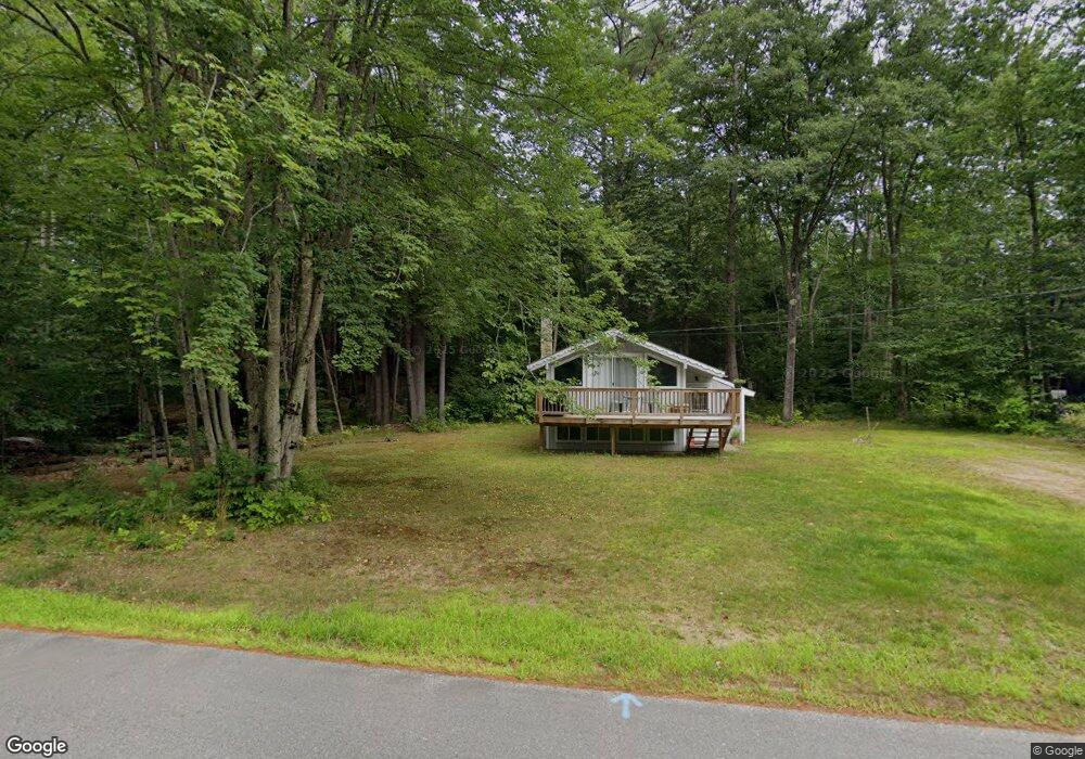
42 Covered Bridge Ln Bartlett, NH 03812
Estimated Value: $322,747 - $393,000
3
Beds
2
Baths
682
Sq Ft
$518/Sq Ft
Est. Value
About This Home
This home is located at 42 Covered Bridge Ln, Bartlett, NH 03812 and is currently estimated at $353,437, approximately $518 per square foot. 42 Covered Bridge Ln is a home with nearby schools including Josiah Bartlett Elementary School.
Ownership History
Date
Name
Owned For
Owner Type
Purchase Details
Closed on
Nov 23, 2010
Sold by
Coughlin Eleanor C and Coughlin Scott E
Bought by
Dawson Matthew R
Current Estimated Value
Home Financials for this Owner
Home Financials are based on the most recent Mortgage that was taken out on this home.
Original Mortgage
$96,000
Outstanding Balance
$63,436
Interest Rate
4.3%
Mortgage Type
Purchase Money Mortgage
Estimated Equity
$290,001
Create a Home Valuation Report for This Property
The Home Valuation Report is an in-depth analysis detailing your home's value as well as a comparison with similar homes in the area
Home Values in the Area
Average Home Value in this Area
Purchase History
| Date | Buyer | Sale Price | Title Company |
|---|---|---|---|
| Dawson Matthew R | $120,000 | -- |
Source: Public Records
Mortgage History
| Date | Status | Borrower | Loan Amount |
|---|---|---|---|
| Open | Dawson Matthew R | $96,000 |
Source: Public Records
Tax History Compared to Growth
Tax History
| Year | Tax Paid | Tax Assessment Tax Assessment Total Assessment is a certain percentage of the fair market value that is determined by local assessors to be the total taxable value of land and additions on the property. | Land | Improvement |
|---|---|---|---|---|
| 2024 | $1,455 | $260,700 | $100,700 | $160,000 |
| 2023 | $1,345 | $260,700 | $100,700 | $160,000 |
| 2022 | $1,296 | $260,700 | $100,700 | $160,000 |
| 2021 | $1,225 | $128,500 | $65,700 | $62,800 |
| 2020 | $1,241 | $128,500 | $65,700 | $62,800 |
| 2019 | $1,200 | $128,500 | $65,700 | $62,800 |
| 2018 | $1,173 | $128,500 | $65,700 | $62,800 |
| 2016 | $1,138 | $119,800 | $55,800 | $64,000 |
| 2015 | $1,143 | $119,800 | $55,800 | $64,000 |
| 2014 | $1,173 | $119,800 | $55,800 | $64,000 |
| 2010 | $1,141 | $124,700 | $48,400 | $76,300 |
Source: Public Records
Map
Nearby Homes
- 791 W Side Rd
- 17 Pickering Rd
- 41 Linden Rd
- 12G Seasons at Attitash Rd
- 4 Seasons at Attitash Rd Unit D
- 1 Seasons at Attitash Rd
- 2 Seasons at Attitash Rd
- 17 The Meadows Rd
- 31 Cave Mountain Rd
- 166 U S 302
- 30 Top Notch Rd Unit 30
- 46 Ammonoosuc Dr
- 2E/F River Run Dr Unit E/F
- 8 River Run Dr Unit J
- 8 River Run Dr Unit H
- 8 River Run Dr Unit G
- 419 Glen Ledge Rd
- 10 River Run Dr Unit G
- N2 Sandtrap Loop Unit 2
- 22 Sandtrap Loop Unit N3
- 42 Covered Bridge Ln
- 48 Covered Bridge Ln
- 48 Covered Bridge Ln
- 40 Covered Bridge Ln
- 40 Covered Bridge Ln
- 45 Covered Bridge Ln
- 17 Aspen Ln
- 29 Aspen Dr
- 17 Aspen Dr
- 42 Aspen Dr
- 44 Aspen Dr
- 52 Covered Bridge Ln
- 49 Covered Bridge Ln
- 37 Covered Bridge Ln
- 269 Covered Bridge Ln
- 53 Covered Bridge Ln
- 37 Aspen Dr
- 8 Aspen Ln
- 19 Aspen Ln
- 273 Covered Bridge Ln