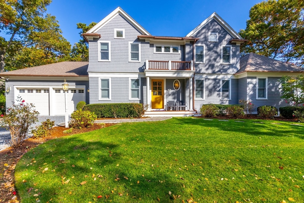
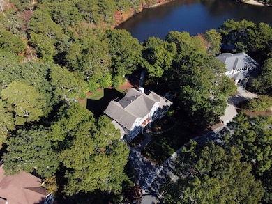

42 Fells Pond Rd Mashpee, MA 02649
New Seabury-Popponesset Island NeighborhoodEstimated payment $12,109/month
Highlights
- Marina
- Golf Course Community
- Open Floorplan
- Mashpee High School Rated A-
- Scenic Views
- Cape Cod Architecture
About This Home
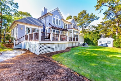
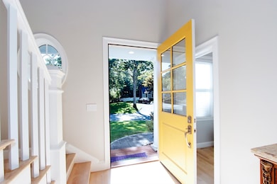
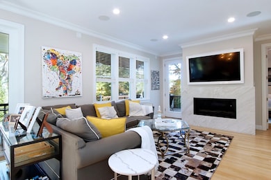
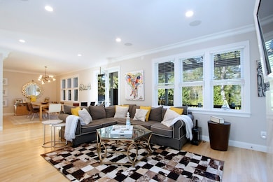
Waterviews at New Seabury! Discover this beautiful 3 bedroom, 3.5 bath custom-built Cape with direct access to Fells Pond, perfect for swimming, kayaking and enjoying the serene natural setting. This thoughtfully designed home offers an inviting open floor plan perfect for modern living and entertaining. Beautiful kitchen with center island, stone countertops, and stainless steel appliances opens to the spacious living room with a gas fireplace and dining area. Primary ensuite with walk-in closet, luxurious bath featuring a double vanity, tiled shower stall and slider to the deck. Home office, laundry and half bath complete the first floor. Upstairs you will find two additional ensuite bedrooms for guests or family, loft area with access to a deck overlooking the yard offering scenic pond views. Expansive deck ideal for entertaining, shed for extra storage, 2 car garage, gas heat & central air. All parties to verify information contained herein.
Listing Agent
Jamie Regan
Keller Williams Realty Listed on: 10/24/2025

Home Details
Home Type
- Single Family
Est. Annual Taxes
- $8,245
Year Built
- Built in 2003
Lot Details
- 0.35 Acre Lot
- Street terminates at a dead end
- Level Lot
- Wooded Lot
- Property is zoned R3
HOA Fees
- $67 Monthly HOA Fees
Parking
- 2 Car Attached Garage
- Stone Driveway
Property Views
- Pond
- Scenic Vista
Home Design
- Cape Cod Architecture
- Contemporary Architecture
- Shingle Roof
- Concrete Perimeter Foundation
Interior Spaces
- 2,516 Sq Ft Home
- Open Floorplan
- Wired For Sound
- Cathedral Ceiling
- Ceiling Fan
- Recessed Lighting
- Pocket Doors
- French Doors
- Sliding Doors
- Entrance Foyer
- Living Room with Fireplace
- Dining Area
- Home Office
- Loft
Kitchen
- Breakfast Bar
- Oven
- Stove
- Range with Range Hood
- Microwave
- Dishwasher
- Wine Refrigerator
- Stainless Steel Appliances
- Kitchen Island
- Solid Surface Countertops
- Disposal
Flooring
- Wood
- Marble
- Ceramic Tile
Bedrooms and Bathrooms
- 3 Bedrooms
- Primary Bedroom on Main
- Walk-In Closet
- Double Vanity
- Soaking Tub
- Bathtub with Shower
- Separate Shower
Laundry
- Laundry on main level
- Dryer
- Washer
Basement
- Partial Basement
- Interior and Exterior Basement Entry
Outdoor Features
- Balcony
- Deck
- Outdoor Storage
- Rain Gutters
Utilities
- Forced Air Heating and Cooling System
- Heating System Uses Natural Gas
- Gas Water Heater
- Private Sewer
Listing and Financial Details
- Assessor Parcel Number M:116 B:23 L:0,2345436
Community Details
Overview
- Fells Pond Village Subdivision
Amenities
- Shops
Recreation
- Marina
- Golf Course Community
- Bike Trail
Map
Home Values in the Area
Average Home Value in this Area
Tax History
| Year | Tax Paid | Tax Assessment Tax Assessment Total Assessment is a certain percentage of the fair market value that is determined by local assessors to be the total taxable value of land and additions on the property. | Land | Improvement |
|---|---|---|---|---|
| 2025 | $8,245 | $1,245,400 | $367,800 | $877,600 |
| 2024 | $7,597 | $1,181,500 | $334,500 | $847,000 |
| 2023 | $6,943 | $990,400 | $294,000 | $696,400 |
| 2022 | $6,677 | $817,300 | $239,000 | $578,300 |
| 2021 | $6,550 | $722,200 | $215,300 | $506,900 |
| 2020 | $6,528 | $718,200 | $224,300 | $493,900 |
| 2019 | $6,231 | $688,500 | $224,300 | $464,200 |
| 2018 | $5,965 | $668,700 | $224,300 | $444,400 |
| 2017 | $6,031 | $656,300 | $224,300 | $432,000 |
| 2016 | $5,833 | $631,300 | $224,300 | $407,000 |
| 2015 | $5,594 | $614,100 | $224,300 | $389,800 |
| 2014 | $5,393 | $574,300 | $220,900 | $353,400 |
Property History
| Date | Event | Price | List to Sale | Price per Sq Ft |
|---|---|---|---|---|
| 10/24/2025 10/24/25 | For Sale | $2,150,000 | -- | $855 / Sq Ft |
Purchase History
| Date | Type | Sale Price | Title Company |
|---|---|---|---|
| Quit Claim Deed | -- | None Available | |
| Deed | $790,000 | -- | |
| Deed | $180,000 | -- | |
| Deed | $45,000 | -- |
Mortgage History
| Date | Status | Loan Amount | Loan Type |
|---|---|---|---|
| Previous Owner | $592,500 | Purchase Money Mortgage | |
| Previous Owner | $118,500 | No Value Available |
Source: MLS Property Information Network (MLS PIN)
MLS Number: 73447518
APN: MASH-000116-000023
Disclaimer: Certain information contained herein is derived from information provided by parties other than Homes.com. All information provided is deemed reliable, but is not guaranteed to be accurate and should be independently verified.
![]() The property listing data and information, or the Images, set forth herein were provided to MLS Property Information Network, Inc. from third party sources, including sellers, lessors and public records, and were compiled by MLS Property Information Network, Inc. The property listing data and information, and the Images, are for the personal, non-commercial use of consumers having a good faith interest in purchasing or leasing listed properties of the type displayed to them and may not be used for any purpose other than to identify prospective properties which such consumers may have a good faith interest in purchasing or leasing. MLS Property Information Network, Inc. and its subscribers disclaim any and all representations and warranties as to the accuracy of the property listing data and information, or as to the accuracy of any of the Images, set forth herein.
The property listing data and information, or the Images, set forth herein were provided to MLS Property Information Network, Inc. from third party sources, including sellers, lessors and public records, and were compiled by MLS Property Information Network, Inc. The property listing data and information, and the Images, are for the personal, non-commercial use of consumers having a good faith interest in purchasing or leasing listed properties of the type displayed to them and may not be used for any purpose other than to identify prospective properties which such consumers may have a good faith interest in purchasing or leasing. MLS Property Information Network, Inc. and its subscribers disclaim any and all representations and warranties as to the accuracy of the property listing data and information, or as to the accuracy of any of the Images, set forth herein.
- 21 Saltwater Cir
- 16 Slice Way
- 72 Walton Heath Way
- 51 Walton Heath Way
- 236 Glenneagle Dr
- 381 Great Oak Rd Unit 9
- 51 Fairway Ln
- 3 Hyannis Point Rd Unit 790
- 3 Hyannis Point Rd
- 6 Hammock Pond Rd
- 6 Hammock Pond Rd Unit 6
- 89 Troon Way
- 4 Colemans Way Unit 702
- 4 Colemans Way
- 2 Brant Rock Rd
- 33 Landmark Ave
- 2 Brant Rock Rd Unit 722
- 25 Milestone Way Unit 25
- 25 Milestone Way
- 128 Uncle Percys Rd
- 29 Landmark Ave
- 4 Debbie Ln
- 87 Seapit Rd Unit Rd
- 5 Bailey Dr
- 235 Edgewater Dr W
- 65 Paola Dr
- 185 Monhegan Rd Unit Main house
- 35 Ocean View Ave
- 556 Carriage Shop Rd
- 94 Doran Dr Unit n/a
- 94 Doran Dr
- 93 Twin Hill Rd Unit 2
- 14 Pga Ln
- 70 Cape Dr Unit 4C
- 42 Meadow View Dr
- 19 Rolling Acres Ln
- 65 St Marks Rd
- 495 Sandwich Rd
- 89 Eisenhower Dr
- 766 Putnam Ave