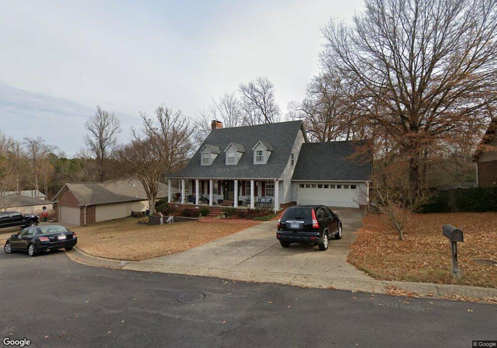
4235 Ginger Dr Benton, AR 72019
Estimated Value: $292,000 - $463,000
4
Beds
4
Baths
3,300
Sq Ft
$117/Sq Ft
Est. Value
About This Home
This home is located at 4235 Ginger Dr, Benton, AR 72019 and is currently estimated at $387,188, approximately $117 per square foot. 4235 Ginger Dr is a home located in Saline County with nearby schools including Perrin Elementary School, Benton Middle School, and Benton Junior High School.
Ownership History
Date
Name
Owned For
Owner Type
Purchase Details
Closed on
Dec 16, 2011
Sold by
Davis Rusty W and Davis Kacie L
Bought by
Bivens James T and Bivens Linda
Current Estimated Value
Home Financials for this Owner
Home Financials are based on the most recent Mortgage that was taken out on this home.
Original Mortgage
$135,000
Outstanding Balance
$54,269
Interest Rate
4.02%
Mortgage Type
New Conventional
Estimated Equity
$332,919
Purchase Details
Closed on
Mar 18, 2004
Bought by
Davis
Purchase Details
Closed on
Mar 17, 2003
Bought by
Light
Purchase Details
Closed on
Apr 1, 1990
Bought by
Malcolm
Create a Home Valuation Report for This Property
The Home Valuation Report is an in-depth analysis detailing your home's value as well as a comparison with similar homes in the area
Home Values in the Area
Average Home Value in this Area
Purchase History
| Date | Buyer | Sale Price | Title Company |
|---|---|---|---|
| Bivens James T | $227,000 | None Available | |
| Bivens James T | $227,000 | None Available | |
| Davis | $180,000 | -- | |
| Light | $177,000 | -- | |
| Malcolm | $13,000 | -- |
Source: Public Records
Mortgage History
| Date | Status | Borrower | Loan Amount |
|---|---|---|---|
| Open | Bivens James T | $135,000 | |
| Closed | Bivens James T | $135,000 |
Source: Public Records
Tax History
| Year | Tax Paid | Tax Assessment Tax Assessment Total Assessment is a certain percentage of the fair market value that is determined by local assessors to be the total taxable value of land and additions on the property. | Land | Improvement |
|---|---|---|---|---|
| 2025 | $2,697 | $51,730 | $6,000 | $45,730 |
| 2024 | $2,761 | $51,730 | $6,000 | $45,730 |
| 2023 | $2,155 | $51,730 | $6,000 | $45,730 |
| 2022 | $2,088 | $51,730 | $6,000 | $45,730 |
| 2021 | $1,970 | $42,330 | $4,600 | $37,730 |
| 2020 | $1,790 | $42,330 | $4,600 | $37,730 |
| 2019 | $1,790 | $42,330 | $4,600 | $37,730 |
| 2018 | $1,717 | $42,330 | $4,600 | $37,730 |
| 2017 | $1,623 | $42,330 | $4,600 | $37,730 |
| 2016 | $1,927 | $33,980 | $4,600 | $29,380 |
| 2015 | $1,543 | $33,980 | $4,600 | $29,380 |
| 2014 | $1,556 | $33,980 | $4,600 | $29,380 |
Source: Public Records
Map
Nearby Homes
- 1702 Glenda Ln
- 3913 Sandra Ln
- 20 Acres Congo Rd
- 1971 Scott Salem Rd
- 2023 Longhills Rd E
- 1800 Fox Trail
- 1120 Grand Teton Dr
- 3519 Pelton
- 1122 Grand Teton Dr
- 1108 Grand Teton Dr
- 1710 Troy Cir
- 1104 Grand Teton Dr
- 3505 Pelton
- 1204 Beaverhead Cove
- 1449 Woolridge Dr
- 913 Grand Teton Dr
- 00 Congo Rd
- 909 Grand Teton Dr
- 1906 Deerfield
- 3221 Drake Dr
- 4321 Ginger Dr
- 4231 Ginger Dr
- 4234 Ginger Dr
- 4227 Ginger Dr
- 4406 Ginger Dr
- 4405 Ginger Dr
- 4230 Ginger Dr
- 4325 Angela Ct
- 4223 Ginger Dr
- 1717 Michael Dr
- 4226 Ginger Dr
- 4415 Ginger Dr
- 4315 Angela Ct
- 4403 Angela Ct
- 1707 Michael Dr
- 4419 Michael Dr
- 4219 Ginger Dr
- 1720 Michael Dr
- 4222 Ginger Dr
- 4316 Angela Ct
Your Personal Tour Guide
Ask me questions while you tour the home.