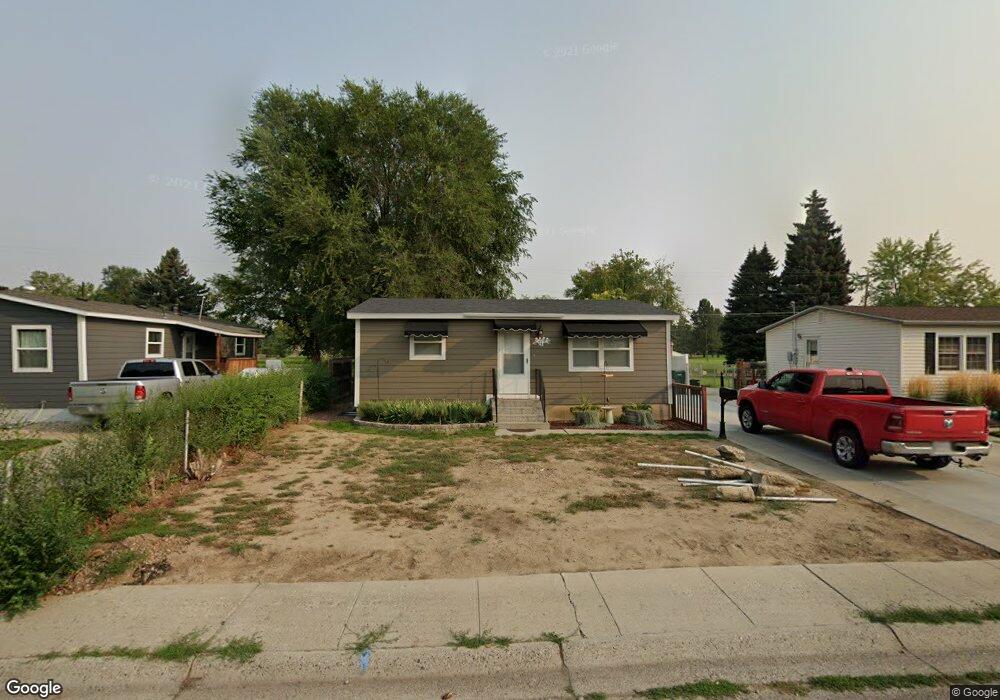
4239 Phillip St Billings, MT 59101
South Central Billings NeighborhoodEstimated Value: $259,000 - $281,000
4
Beds
1
Bath
1,536
Sq Ft
$175/Sq Ft
Est. Value
About This Home
This home is located at 4239 Phillip St, Billings, MT 59101 and is currently estimated at $269,216, approximately $175 per square foot. 4239 Phillip St is a home located in Yellowstone County with nearby schools including Ponderosa School, Riverside Junior High School, and Billings Senior High School.
Ownership History
Date
Name
Owned For
Owner Type
Purchase Details
Closed on
Jun 27, 2024
Sold by
Stuart Michael L and Stuart Tanya M
Bought by
Brangers Willis D
Current Estimated Value
Home Financials for this Owner
Home Financials are based on the most recent Mortgage that was taken out on this home.
Original Mortgage
$13,250
Outstanding Balance
$7,354
Interest Rate
7.02%
Mortgage Type
New Conventional
Estimated Equity
$261,862
Purchase Details
Closed on
Sep 1, 2020
Sold by
Smith Alan J
Bought by
Stuart Michael L and Stuart Tanya M
Home Financials for this Owner
Home Financials are based on the most recent Mortgage that was taken out on this home.
Original Mortgage
$66,640
Interest Rate
3%
Mortgage Type
Commercial
Create a Home Valuation Report for This Property
The Home Valuation Report is an in-depth analysis detailing your home's value as well as a comparison with similar homes in the area
Home Values in the Area
Average Home Value in this Area
Purchase History
| Date | Buyer | Sale Price | Title Company |
|---|---|---|---|
| Brangers Willis D | -- | First Montana Title | |
| Stuart Michael L | -- | First Montana Title Co |
Source: Public Records
Mortgage History
| Date | Status | Borrower | Loan Amount |
|---|---|---|---|
| Open | Brangers Willis D | $13,250 | |
| Open | Brangers Willis D | $254,883 | |
| Previous Owner | Stuart Michael L | $66,640 |
Source: Public Records
Tax History
| Year | Tax Paid | Tax Assessment Tax Assessment Total Assessment is a certain percentage of the fair market value that is determined by local assessors to be the total taxable value of land and additions on the property. | Land | Improvement |
|---|---|---|---|---|
| 2025 | $1,985 | $254,700 | $37,444 | $217,256 |
| 2024 | $1,985 | $205,400 | $36,390 | $169,010 |
| 2023 | $1,883 | $193,800 | $36,390 | $157,410 |
| 2022 | $1,493 | $158,200 | $0 | $0 |
| 2021 | $1,665 | $158,200 | $0 | $0 |
| 2020 | $1,507 | $131,800 | $0 | $0 |
| 2019 | $1,440 | $131,800 | $0 | $0 |
| 2018 | $1,475 | $133,400 | $0 | $0 |
| 2017 | $1,235 | $133,400 | $0 | $0 |
| 2016 | $1,384 | $130,800 | $0 | $0 |
| 2015 | $1,353 | $130,800 | $0 | $0 |
| 2014 | $1,148 | $58,035 | $0 | $0 |
Source: Public Records
Map
Nearby Homes
- 449 Orchard Ln
- 4413 Ryan Ave
- 459 Hillview Ln
- 820 Arlington Dr Unit 25
- 4531 Phillip St
- 4237 Clevenger Ave
- 4124 Vaughn Ln
- 418 Byrd St
- 4115 Vaughn Ln
- 313 Viceroy St
- 4429 Clevenger Ave
- 329 Jackson St
- 315 Jackson St
- 312 Monroe St
- 329 Monroe St
- 356 Jefferson St
- 720 Washington St
- 122 Orchard Ln
- 307 S Billings Blvd Unit 24
- 307 S Billings Blvd Unit 36
- 4235 Phillip St
- 4243 Phillip St
- 4231 Phillip St
- 603 Stephens Ln
- 4227 Phillip St
- 4238 Phillip St
- 4234 Phillip St
- 4242 Phillip St
- 4223 Phillip St
- 4230 Phillip St
- 619 Stephens Ln
- 4303 Phillip St
- 4226 Phillip St
- 4219 Phillip St
- 4302 Ryan Ave
- 4222 Phillip St
- 4307 Phillip St
- 4215 Phillip St
- 4306 Phillip St
- 4218 Phillip St
Your Personal Tour Guide
Ask me questions while you tour the home.