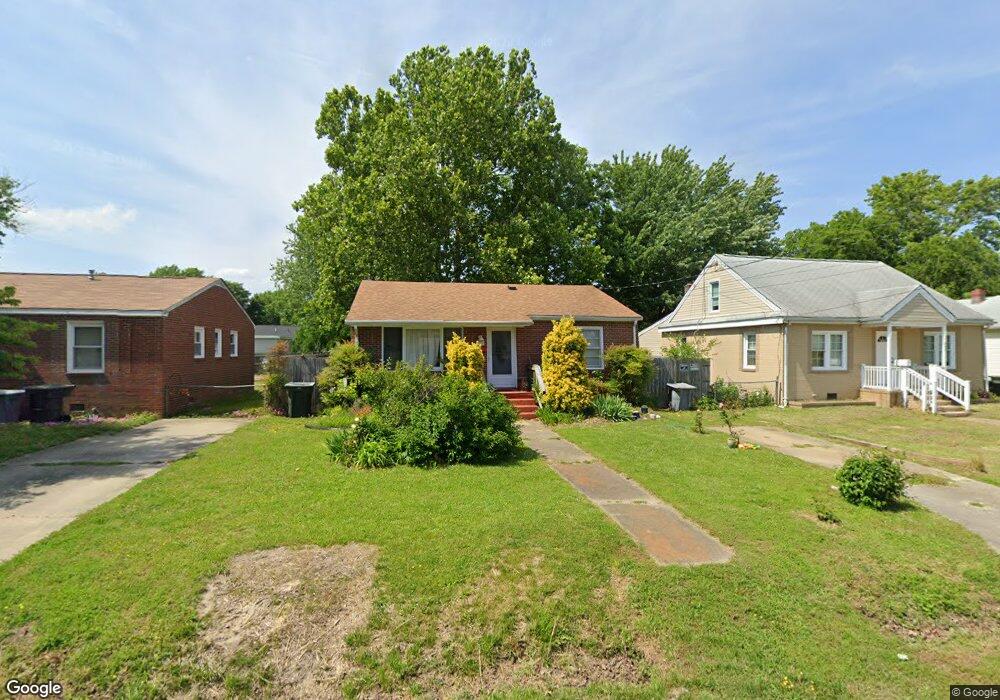
426 Benthall Rd Hampton, VA 23664
Buckroe Beach NeighborhoodEstimated Value: $185,000 - $312,000
3
Beds
1
Bath
960
Sq Ft
$238/Sq Ft
Est. Value
About This Home
This home is located at 426 Benthall Rd, Hampton, VA 23664 and is currently estimated at $228,139, approximately $237 per square foot. 426 Benthall Rd is a home located in Hampton City with nearby schools including Francis Asbury Elementary School, Benjamin Syms Middle School, and Phoebus High School.
Ownership History
Date
Name
Owned For
Owner Type
Purchase Details
Closed on
Jul 11, 2014
Sold by
Wishon Chester E
Bought by
West Mary K
Current Estimated Value
Home Financials for this Owner
Home Financials are based on the most recent Mortgage that was taken out on this home.
Original Mortgage
$69,000
Outstanding Balance
$52,518
Interest Rate
4.14%
Mortgage Type
New Conventional
Estimated Equity
$175,621
Purchase Details
Closed on
Jul 26, 2011
Sold by
Bank Of America Na
Bought by
Wishon Chester E
Purchase Details
Closed on
Mar 23, 2011
Sold by
Any Na Recontrust Comp and Doop Anne W
Bought by
Bac Home Loans Servicing Lp
Create a Home Valuation Report for This Property
The Home Valuation Report is an in-depth analysis detailing your home's value as well as a comparison with similar homes in the area
Home Values in the Area
Average Home Value in this Area
Purchase History
| Date | Buyer | Sale Price | Title Company |
|---|---|---|---|
| West Mary K | $105,900 | -- | |
| Wishon Chester E | $53,800 | -- | |
| Bac Home Loans Servicing Lp | $87,300 | -- |
Source: Public Records
Mortgage History
| Date | Status | Borrower | Loan Amount |
|---|---|---|---|
| Open | West Mary K | $69,000 |
Source: Public Records
Tax History
| Year | Tax Paid | Tax Assessment Tax Assessment Total Assessment is a certain percentage of the fair market value that is determined by local assessors to be the total taxable value of land and additions on the property. | Land | Improvement |
|---|---|---|---|---|
| 2025 | $1,933 | $162,200 | $55,000 | $107,200 |
| 2024 | $1,722 | $149,700 | $55,000 | $94,700 |
| 2023 | $1,611 | $138,900 | $50,000 | $88,900 |
| 2022 | $1,481 | $125,500 | $42,000 | $83,500 |
| 2021 | $1,483 | $109,100 | $35,000 | $74,100 |
| 2020 | $1,251 | $100,900 | $35,000 | $65,900 |
| 2019 | $1,251 | $100,900 | $35,000 | $65,900 |
| 2018 | $1,346 | $98,600 | $35,000 | $63,600 |
| 2017 | $1,317 | $0 | $0 | $0 |
| 2016 | $1,375 | $103,300 | $0 | $0 |
| 2015 | $1,375 | $0 | $0 | $0 |
| 2014 | $1,409 | $103,300 | $35,200 | $68,100 |
Source: Public Records
Map
Nearby Homes
- 417 Hunlac Ave
- 403 Benthall Rd
- 408 Rogers Ave
- 449 Benthall Rd
- 205 Benthall Rd
- 309 Benthall Rd
- 1040 Porte Harbour Arch
- 307 N First St
- 231 Benthall Rd
- 1030 Porte Harbour Arch
- 750 N First St
- 14 Jayne Lee Dr
- 1003 High Dunes Quay Unit 101
- 334 N First St Unit 18
- 334 N First St
- 235 N First St
- 13 Fields Dr
- 774 N First St
- 1031 High Dunes Quay Unit 103
- 2013 N Mallory St
- 424 Benthall Rd
- 428 Benthall Rd
- 430 Benthall Rd
- 420 Benthall Rd
- 425 Rogers Ave
- 427 Rogers Ave
- 423 Rogers Ave
- 429 Rogers Ave
- 421 Rogers Ave
- 418 Benthall Rd
- 432 Benthall Rd
- 421 Benthall Rd
- 423 Benthall Rd
- 417 Benthall Rd
- 419 Rogers Ave Unit Avenue
- 416 Benthall Rd
- 434 Benthall Rd
- 419 Benthall Rd
- 433 Rogers Ave
- 415 Benthall Rd
Your Personal Tour Guide
Ask me questions while you tour the home.