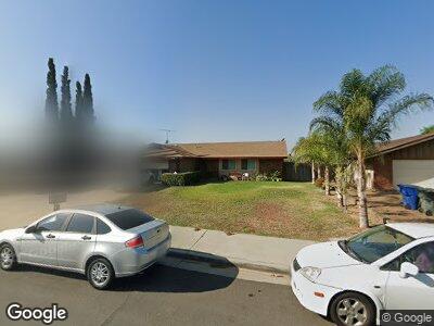
4278 Quenton Dr Riverside, CA 92505
La Sierra NeighborhoodEstimated Value: $592,000 - $692,000
3
Beds
2
Baths
1,380
Sq Ft
$460/Sq Ft
Est. Value
About This Home
This home is located at 4278 Quenton Dr, Riverside, CA 92505 and is currently estimated at $634,516, approximately $459 per square foot. 4278 Quenton Dr is a home located in Riverside County with nearby schools including Myra Linn Elementary School, Arizona Middle School, and La Sierra High School.
Ownership History
Date
Name
Owned For
Owner Type
Purchase Details
Closed on
Nov 2, 2022
Sold by
Arvayo Juan A and Arvayo Olivia Garcia
Bought by
Arvayo Family Trust
Current Estimated Value
Purchase Details
Closed on
Jan 12, 2012
Sold by
Arvayo Lizet and Arvayo Olivia
Bought by
Arvayo Juan Antonio and Arvayo Olivia
Purchase Details
Closed on
Jun 18, 2010
Sold by
Arvayo Juan Antonio and Arvayo Olivia
Bought by
Arvayo Lizet and Arvayo Olivia
Purchase Details
Closed on
Oct 12, 2001
Sold by
Arvayo Juan Antonio and Arvayo Olivia
Bought by
Arvayo Juan Antonio and Arvayo Olivia
Home Financials for this Owner
Home Financials are based on the most recent Mortgage that was taken out on this home.
Original Mortgage
$140,562
Interest Rate
6.88%
Mortgage Type
Stand Alone First
Create a Home Valuation Report for This Property
The Home Valuation Report is an in-depth analysis detailing your home's value as well as a comparison with similar homes in the area
Home Values in the Area
Average Home Value in this Area
Purchase History
| Date | Buyer | Sale Price | Title Company |
|---|---|---|---|
| Arvayo Family Trust | -- | -- | |
| Arvayo Juan Antonio | -- | None Available | |
| Arvayo Lizet | -- | None Available | |
| Arvayo Juan Antonio | -- | Commonwealth Land Title Co |
Source: Public Records
Mortgage History
| Date | Status | Borrower | Loan Amount |
|---|---|---|---|
| Previous Owner | Arvayo Juan Antonio | $140,562 |
Source: Public Records
Tax History Compared to Growth
Tax History
| Year | Tax Paid | Tax Assessment Tax Assessment Total Assessment is a certain percentage of the fair market value that is determined by local assessors to be the total taxable value of land and additions on the property. | Land | Improvement |
|---|---|---|---|---|
| 2023 | $2,598 | $205,225 | $72,430 | $132,795 |
| 2022 | $2,406 | $201,202 | $71,010 | $130,192 |
| 2021 | $2,377 | $197,258 | $69,618 | $127,640 |
| 2020 | $2,339 | $195,237 | $68,905 | $126,332 |
| 2019 | $2,309 | $191,409 | $67,554 | $123,855 |
| 2018 | $2,278 | $187,657 | $66,231 | $121,426 |
| 2017 | $2,236 | $183,979 | $64,933 | $119,046 |
| 2016 | $2,200 | $180,372 | $63,660 | $116,712 |
| 2015 | $2,168 | $177,664 | $62,704 | $114,960 |
| 2014 | $2,160 | $174,186 | $61,477 | $112,709 |
Source: Public Records
Map
Nearby Homes
- 4281 Baggett Dr
- 4290 Tyler St
- 10362 Wagner Way
- 10486 Bonita Ave
- 10308 Adriana Ave
- 10409 Cochran Ave
- 10636 Wolfe Ave
- 9881 Cook Ave
- 10513 Magnolia Ave Unit E2
- 10180 Eddystone St
- 10649 Renner St
- 10656 Renner St
- 3894 Polk St Unit E
- 10730 Foote Ct
- 10806 Bayonne Dr
- 7848 Bolton Ave
- 3747 Polk St
- 3841 Tomlinson Ave
- 4787 Boardwalk Dr
- 9810 Sharon Ave
- 4278 Quenton Dr
- 4284 Quenton Dr
- 4272 Quenton Dr
- 4275 Mercury Ct
- 4269 Mercury Ct
- 4266 Quenton Dr
- 4285 Mercury Ct
- 10372 Brookway Place
- 4277 Quenton Dr
- 4265 Mercury Ct
- 10380 Brookway Place
- 4271 Quenton Dr
- 4283 Quenton Dr
- 10388 Brookway Place
- 10356 Brookway Place
- 4267 Quenton Dr
- 4280 Mercury Ct
- 10390 Brookway Place
- 10348 Brookway Place
- 4270 Mercury Ct