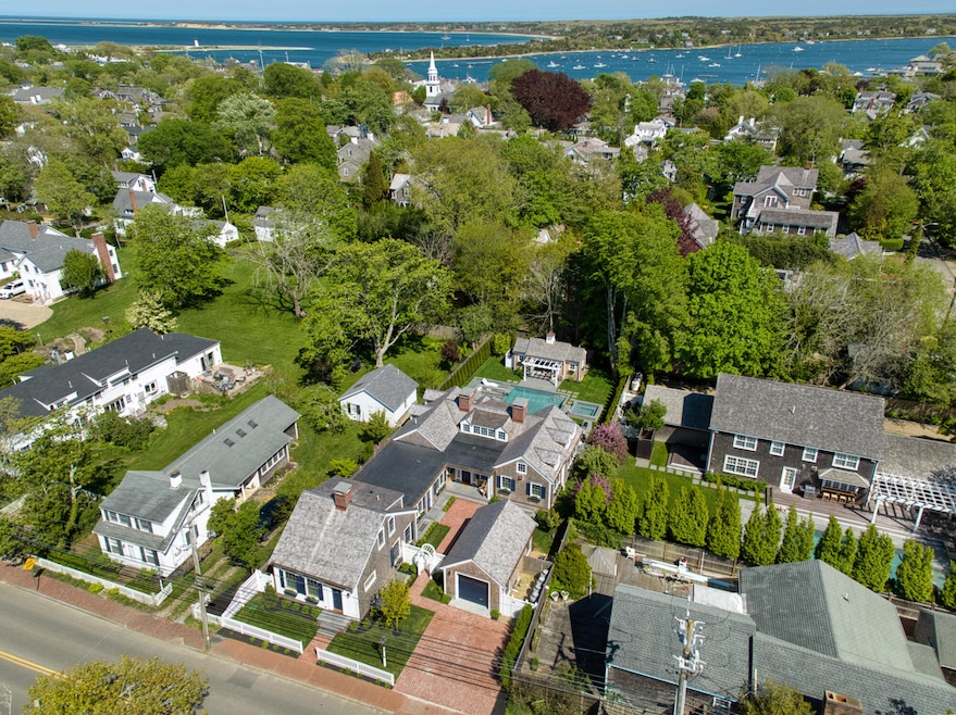

43 Peases Point Way S Edgartown, MA 02539
Edgartown NeighborhoodEstimated payment $51,092/month
Highlights
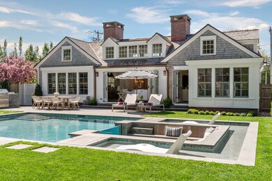
- Private Pool
- 2 Fireplaces
- Central Air
- Wood Flooring
- No HOA
- 1 Car Garage
About This Home
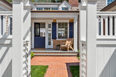
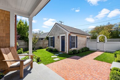
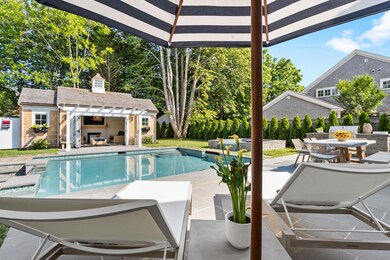
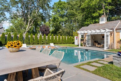
Refined, timeless, and unparalleled, 43 Peases Point Way South effortlessly blends warmth, elegance, and sophistication to create a truly distinctive living experience in one of Edgartown's most coveted locations. Designed by celebrated architect Patrick Ahearn, this exceptional residence is just a short stroll from historic Main Street. From the gated arbor entry and tranquil courtyard to the thoughtfully curated interiors and unique floor plan, every detail reflects impeccable craftsmanship and intentional design. The outdoor living space is equally remarkable, featuring a heated saltwater pool, a sunken fire pit, and a show stopping custom glass wall feature. With a strong, proven rental history, this luxurious retreat offers both investment potential and flexibility for today's discerning buyer. A rare and refreshing opportunity in the heart of Edgartown Village.
Home Details
Home Type
- Single Family
Est. Annual Taxes
- $12,319
Year Built
- Built in 1840 | Remodeled
Lot Details
- 10,454 Sq Ft Lot
- Paved or Partially Paved Lot
- Property is zoned R5
Parking
- 1 Car Garage
Interior Spaces
- 5,458 Sq Ft Home
- 2-Story Property
- 2 Fireplaces
Flooring
- Wood
- Tile
Bedrooms and Bathrooms
- 4 Bedrooms
Finished Basement
- Basement Fills Entire Space Under The House
- Interior Basement Entry
Pool
- Private Pool
Utilities
- Central Air
- Heat Pump System
- Liquid Propane Gas Water Heater
Community Details
- No Home Owners Association
Listing and Financial Details
- Assessor Parcel Number 20c/1811
Map
Home Values in the Area
Average Home Value in this Area
Tax History
| Year | Tax Paid | Tax Assessment Tax Assessment Total Assessment is a certain percentage of the fair market value that is determined by local assessors to be the total taxable value of land and additions on the property. | Land | Improvement |
|---|---|---|---|---|
| 2025 | $12,319 | $4,648,800 | $1,158,400 | $3,490,400 |
| 2024 | $7,161 | $2,808,100 | $1,158,400 | $1,649,700 |
| 2023 | $4,679 | $1,856,600 | $1,117,500 | $739,100 |
| 2022 | $4,682 | $1,545,300 | $1,103,200 | $442,100 |
| 2021 | $5,203 | $1,586,200 | $1,107,100 | $479,100 |
| 2020 | $5,301 | $1,582,400 | $1,107,100 | $475,300 |
| 2019 | $5,447 | $1,407,600 | $976,900 | $430,700 |
| 2018 | $4,142 | $1,316,800 | $941,200 | $375,600 |
| 2017 | $4,041 | $1,138,300 | $778,100 | $360,200 |
| 2016 | $4,079 | $1,126,900 | $778,100 | $348,800 |
| 2015 | $3,629 | $1,045,700 | $704,000 | $341,700 |
Property History
| Date | Event | Price | List to Sale | Price per Sq Ft | Prior Sale |
|---|---|---|---|---|---|
| 09/17/2025 09/17/25 | Price Changed | $9,499,000 | -5.0% | $1,740 / Sq Ft | |
| 06/03/2025 06/03/25 | For Sale | $9,995,000 | +505.8% | $1,831 / Sq Ft | |
| 12/30/2020 12/30/20 | Sold | $1,650,000 | -28.1% | $809 / Sq Ft | View Prior Sale |
| 12/08/2020 12/08/20 | Pending | -- | -- | -- | |
| 02/25/2020 02/25/20 | For Sale | $2,295,000 | -- | $1,125 / Sq Ft |
Purchase History
| Date | Type | Sale Price | Title Company |
|---|---|---|---|
| Quit Claim Deed | -- | None Available | |
| Quit Claim Deed | -- | None Available | |
| Deed | $880,000 | -- | |
| Deed | $880,000 | -- |
Mortgage History
| Date | Status | Loan Amount | Loan Type |
|---|---|---|---|
| Previous Owner | $50,000 | No Value Available |
Source: Martha's Vineyard MLS
MLS Number: 32500180
APN: EDGA-000020C-000188-000001
Disclaimer: Certain information contained herein is derived from information provided by parties other than Homes.com. All information provided is deemed reliable, but is not guaranteed to be accurate and should be independently verified.
![]() IDX information is provided exclusively for personal, non-commercial use, and may not be used for any purpose other than to identify prospective properties consumers may be interested in purchasing. Information is deemed reliable but not guaranteed.
IDX information is provided exclusively for personal, non-commercial use, and may not be used for any purpose other than to identify prospective properties consumers may be interested in purchasing. Information is deemed reliable but not guaranteed.
- 11 Norton St
- 69 School St
- 10 Tilton Way
- 52 S Summer St
- 8 High St
- 10 Peases Point Way N
- 48 W Tisbury Rd
- 48 Edgartown - West Tisbury Rd
- 62 N Summer St
- 25 Dock St
- 23 Pinehurst Rd
- 26 Curtis Ln
- 68 N Water St
- 160 Katama Rd
- 76 Norton Orchard Rd
- 11 Bernard Way
- 7 Clark Dr
- 2 Orchard Ln
- 5 Louis Field Rd
- 5 Louis Field Rd Unit 121.3
- 12 Cottle Lane Ed341
- 19 Morse St
- 7 Mill Hill Farms Rd Ed315
- 54 Schoolhouse Road Ed330
- 60 Witchwood Lane Ed317
- 29 Mercier Way
- 15 Price's Way Ed322
- 175 Meetinghouse Way Ed321
- 1 Meetinghouse Village Way Unit 1 ED335
- 2 Fishermans Knot Rd Ed309 Unit 1
- 9 Thaxter Lane Ed310
- 39 N Neck Rd
- 17 Edgartown Bay Rd Ed328
- 74 Turkeyland Cove Rd Ed306
- 76 Mattakesett Way Ed313
- 97 3rd St N
- 20 Katama Bay Rd Ed350
- 16 Majors Cove Ln
- 40 Hidden Cove Rd
- 2 Nonamessett Rd
