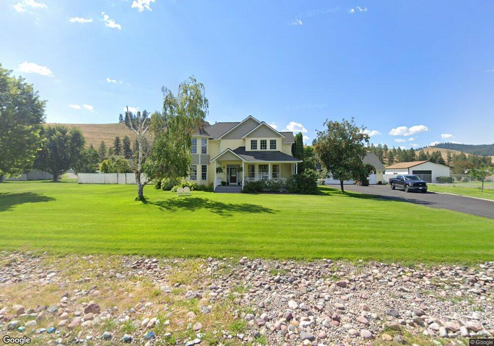
4335 Sundown Rd Missoula, MT 59804
Estimated Value: $1,102,518 - $1,324,000
4
Beds
3
Baths
1,418
Sq Ft
$851/Sq Ft
Est. Value
About This Home
This home is located at 4335 Sundown Rd, Missoula, MT 59804 and is currently estimated at $1,206,506, approximately $850 per square foot. 4335 Sundown Rd is a home located in Missoula County with nearby schools including Target Range School, Big Sky High School, and First Lutheran Classical School.
Ownership History
Date
Name
Owned For
Owner Type
Purchase Details
Closed on
Feb 7, 2005
Sold by
Baker Cheryl
Bought by
Mcquirk Mark and Mcquirk Ellen
Current Estimated Value
Home Financials for this Owner
Home Financials are based on the most recent Mortgage that was taken out on this home.
Original Mortgage
$359,650
Outstanding Balance
$169,071
Interest Rate
4.62%
Mortgage Type
Unknown
Estimated Equity
$1,037,435
Purchase Details
Closed on
Mar 11, 2003
Sold by
Automotive Financial Corp
Bought by
Baker Cheryl
Home Financials for this Owner
Home Financials are based on the most recent Mortgage that was taken out on this home.
Original Mortgage
$300,000
Interest Rate
5.83%
Create a Home Valuation Report for This Property
The Home Valuation Report is an in-depth analysis detailing your home's value as well as a comparison with similar homes in the area
Home Values in the Area
Average Home Value in this Area
Purchase History
| Date | Buyer | Sale Price | Title Company |
|---|---|---|---|
| Mcquirk Mark | -- | -- | |
| Baker Cheryl | -- | -- |
Source: Public Records
Mortgage History
| Date | Status | Borrower | Loan Amount |
|---|---|---|---|
| Open | Mcquirk Mark | $359,650 | |
| Previous Owner | Baker Cheryl | $300,000 | |
| Closed | Baker Cheryl | $37,500 |
Source: Public Records
Tax History Compared to Growth
Tax History
| Year | Tax Paid | Tax Assessment Tax Assessment Total Assessment is a certain percentage of the fair market value that is determined by local assessors to be the total taxable value of land and additions on the property. | Land | Improvement |
|---|---|---|---|---|
| 2025 | $7,620 | $981,300 | $266,000 | $715,300 |
| 2024 | $8,076 | $775,600 | $239,600 | $536,000 |
| 2023 | $7,334 | $775,600 | $239,600 | $536,000 |
| 2022 | $6,373 | $594,100 | $0 | $0 |
| 2021 | $6,176 | $594,100 | $0 | $0 |
| 2020 | $5,885 | $564,000 | $0 | $0 |
| 2019 | $5,839 | $564,000 | $0 | $0 |
| 2018 | $5,188 | $511,000 | $0 | $0 |
| 2017 | $5,189 | $511,000 | $0 | $0 |
| 2016 | $4,920 | $483,500 | $0 | $0 |
| 2015 | $4,753 | $483,500 | $0 | $0 |
| 2014 | $5,000 | $280,476 | $0 | $0 |
Source: Public Records
Map
Nearby Homes
- 3101 Humble Rd
- 2222 Pauline Dr
- Nhn 40th Ave
- 4316 North Ave W
- 2201 Rafferty Ln
- 4230 North Ave W
- 2275 Ruth Louise Ln
- 1522 Clements Rd
- 3522 South Ave W
- 296 Big Flat Rd
- 1211 Kenwood Dr
- 4474 Blue Mountain Rd
- 3720 Sierra Dr
- 325 Big Flat Rd
- 1085 Spurgin Ct
- 2311 Tower St
- 4600 Tiberius Dr
- 4669 Langdon Ct
- 4967 Buckhouse Ln
- 12085 U S Highway 93 S