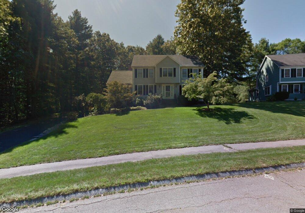
44 Bridle Path Franklin, MA 02038
Estimated Value: $876,000 - $1,050,000
4
Beds
3
Baths
2,340
Sq Ft
$403/Sq Ft
Est. Value
About This Home
This home is located at 44 Bridle Path, Franklin, MA 02038 and is currently estimated at $942,230, approximately $402 per square foot. 44 Bridle Path is a home located in Norfolk County with nearby schools including Helen Keller Elementary School, Annie Sullivan Middle School, and Franklin High School.
Ownership History
Date
Name
Owned For
Owner Type
Purchase Details
Closed on
Aug 30, 2007
Sold by
Migroup Inc
Bought by
Okeefe Jodi Joy and Okeefe Matthew I
Current Estimated Value
Home Financials for this Owner
Home Financials are based on the most recent Mortgage that was taken out on this home.
Original Mortgage
$77,100
Interest Rate
6.71%
Mortgage Type
Purchase Money Mortgage
Purchase Details
Closed on
Jun 19, 1996
Sold by
Urquhart William L
Bought by
Piccirillo Robert A and Piccirillo Phylis M
Purchase Details
Closed on
Jul 1, 1992
Sold by
Stivaletta Corp
Bought by
Urquhart William L
Create a Home Valuation Report for This Property
The Home Valuation Report is an in-depth analysis detailing your home's value as well as a comparison with similar homes in the area
Purchase History
| Date | Buyer | Sale Price | Title Company |
|---|---|---|---|
| Okeefe Jodi Joy | $514,000 | -- | |
| Migroup Inc | $514,000 | -- | |
| Piccirillo Robert A | $245,000 | -- | |
| Urquhart William L | $22,000 | -- |
Source: Public Records
Mortgage History
| Date | Status | Borrower | Loan Amount |
|---|---|---|---|
| Open | Urquhart William L | $407,000 | |
| Closed | Migroup Inc | $77,100 | |
| Closed | Migroup Inc | $411,200 |
Source: Public Records
Tax History
| Year | Tax Paid | Tax Assessment Tax Assessment Total Assessment is a certain percentage of the fair market value that is determined by local assessors to be the total taxable value of land and additions on the property. | Land | Improvement |
|---|---|---|---|---|
| 2025 | $8,867 | $763,100 | $361,000 | $402,100 |
| 2024 | $8,997 | $763,100 | $361,000 | $402,100 |
| 2023 | $8,796 | $699,200 | $335,000 | $364,200 |
| 2022 | $8,565 | $609,600 | $288,800 | $320,800 |
| 2021 | $8,050 | $549,500 | $277,100 | $272,400 |
| 2020 | $7,818 | $538,800 | $279,900 | $258,900 |
| 2019 | $7,856 | $535,900 | $277,100 | $258,800 |
| 2018 | $7,414 | $506,100 | $274,300 | $231,800 |
| 2017 | $7,503 | $514,600 | $282,800 | $231,800 |
| 2016 | $6,850 | $472,400 | $244,500 | $227,900 |
| 2015 | $6,881 | $463,700 | $235,800 | $227,900 |
| 2014 | $6,420 | $444,300 | $216,400 | $227,900 |
Source: Public Records
Map
Nearby Homes
- 41 Kimberlee Ave
- 204 Lincoln St
- 43 Grey Wolf Dr Unit 13
- 70 Daniels St
- 91 Oliver Pond Cir Unit 3
- 83 Oliver Pond Cir Unit 7
- 17 Longhill Rd
- 24 Shayne Rd Unit 110
- 70 Oak St
- 254 Daniels St
- 12 Garden St
- 266 Pleasant St
- 7 Glenwood Rd
- 14 Pleasant St Unit B
- 134 Highwood Dr
- 2 Skyline Dr
- 2211 Franklin Crossing Rd Unit 2211
- 33 Elm St
- 1801 Franklin Crossing Rd Unit 1801
- 57 Raymond St Unit 2