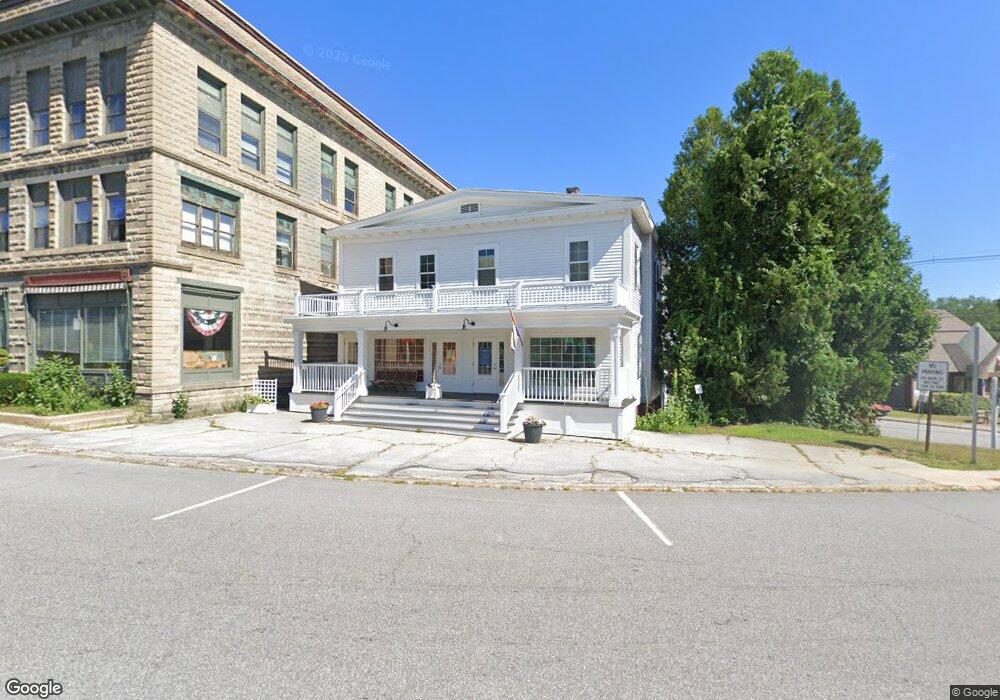
44 Main St Ashland, NH 03217
Estimated Value: $488,432
5
Beds
5
Baths
3,935
Sq Ft
$124/Sq Ft
Est. Value
About This Home
This home is located at 44 Main St, Ashland, NH 03217 and is currently estimated at $488,432, approximately $124 per square foot. 44 Main St is a home located in Grafton County with nearby schools including Ashland Elementary School and Plymouth Regional High School.
Ownership History
Date
Name
Owned For
Owner Type
Purchase Details
Closed on
Feb 10, 2016
Sold by
Polos Whyth Hldg Llc
Bought by
La Rocca Enterprises L
Current Estimated Value
Home Financials for this Owner
Home Financials are based on the most recent Mortgage that was taken out on this home.
Original Mortgage
$130,000
Outstanding Balance
$103,868
Interest Rate
4.02%
Mortgage Type
Commercial
Estimated Equity
$384,564
Create a Home Valuation Report for This Property
The Home Valuation Report is an in-depth analysis detailing your home's value as well as a comparison with similar homes in the area
Purchase History
| Date | Buyer | Sale Price | Title Company |
|---|---|---|---|
| La Rocca Enterprises L | $220,000 | -- | |
| Polos Whyth Hldg Llc | -- | -- |
Source: Public Records
Mortgage History
| Date | Status | Borrower | Loan Amount |
|---|---|---|---|
| Open | Polos Whyth Hldg Llc | $130,000 | |
| Previous Owner | Polos Whyth Hldg Llc | $230,000 |
Source: Public Records
Tax History
| Year | Tax Paid | Tax Assessment Tax Assessment Total Assessment is a certain percentage of the fair market value that is determined by local assessors to be the total taxable value of land and additions on the property. | Land | Improvement |
|---|---|---|---|---|
| 2024 | $7,311 | $397,560 | $117,800 | $279,760 |
| 2023 | $6,878 | $397,560 | $117,800 | $279,760 |
| 2022 | $7,850 | $281,660 | $60,500 | $221,160 |
| 2021 | $7,737 | $281,660 | $60,500 | $221,160 |
| 2020 | $7,695 | $270,660 | $60,500 | $210,160 |
| 2019 | $7,565 | $270,660 | $60,500 | $210,160 |
| 2018 | $5,975 | $259,660 | $60,500 | $199,160 |
| 2016 | $5,902 | $242,200 | $60,400 | $181,800 |
| 2015 | $6,048 | $242,200 | $60,400 | $181,800 |
| 2013 | $7,488 | $298,100 | $60,400 | $237,700 |
Source: Public Records
Map
Nearby Homes
- 121 Riverside Dr
- 12 Peaked Hill Rd
- 283 River St
- 11 Sebec Rd
- 7 Ledges Rd Unit (aka Unit 79)
- 13 Pine Arden Dr Unit 70
- 206 High Country Way Unit (aka Unit 100)
- 15-B Wildflower Ln
- 14 Cummings Hill Rd
- 793 Texas Hill Rd
- 373 New Hampshire Route 175
- 88 Perch Pond Rd
- 0 Texas Hill Rd Unit 2
- 00 Texas Hill Rd Unit 59
- 0 Texas Hill Rd Unit 1
- 148 Sargent Rd
- 20 Circle Dr Unit 43
- 0 Oak Ridge Rd Unit 27
- 000 Smith Rd Unit 2
- 384 New Hampshire 113
Your Personal Tour Guide
Ask me questions while you tour the home.