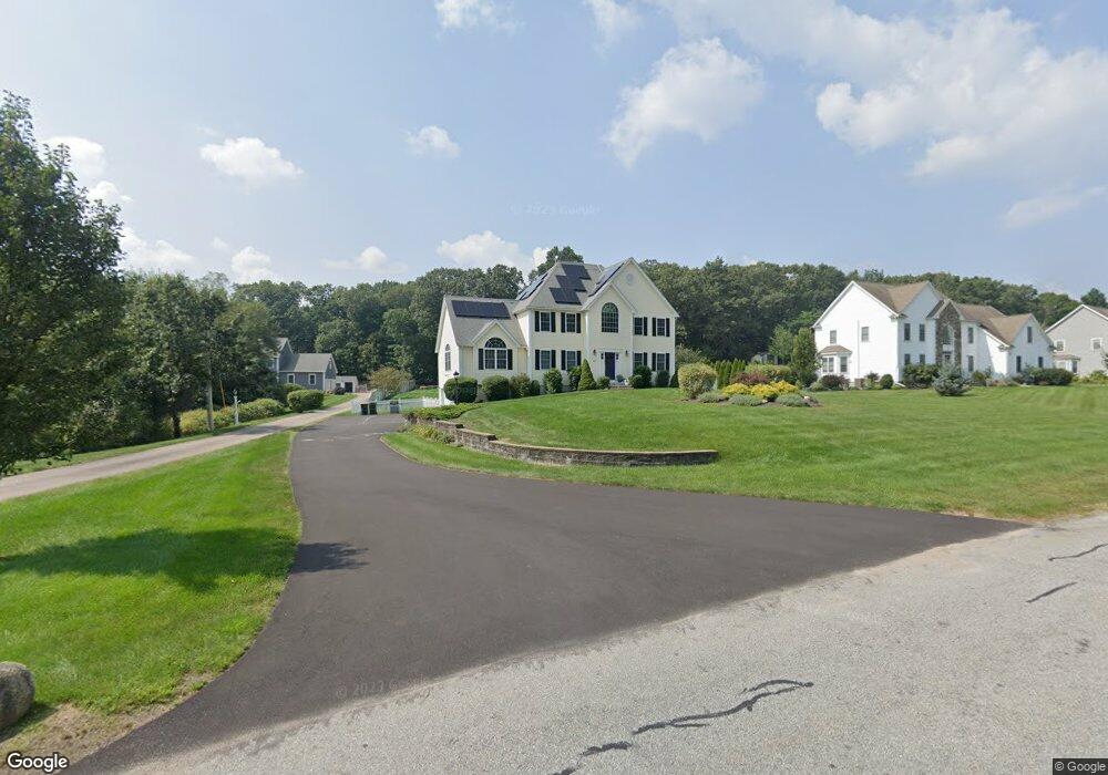
472 Maple St Franklin, MA 02038
Estimated Value: $953,516 - $1,321,000
3
Beds
3
Baths
3,065
Sq Ft
$350/Sq Ft
Est. Value
About This Home
This home is located at 472 Maple St, Franklin, MA 02038 and is currently estimated at $1,073,379, approximately $350 per square foot. 472 Maple St is a home located in Norfolk County with nearby schools including Oak Street Elementary School, Horace Mann Middle School, and Franklin High School.
Ownership History
Date
Name
Owned For
Owner Type
Purchase Details
Closed on
May 19, 2010
Sold by
Phillips Joshua W and Phillips Jennifer A
Bought by
Macdonald Ian W and Macdonald Caitlin A
Current Estimated Value
Home Financials for this Owner
Home Financials are based on the most recent Mortgage that was taken out on this home.
Original Mortgage
$490,000
Outstanding Balance
$330,054
Interest Rate
5.23%
Mortgage Type
Purchase Money Mortgage
Estimated Equity
$743,325
Purchase Details
Closed on
Mar 16, 2007
Sold by
Triple D Llc
Bought by
Phillips Jennifer A and Phillips Joshua W
Home Financials for this Owner
Home Financials are based on the most recent Mortgage that was taken out on this home.
Original Mortgage
$483,200
Interest Rate
6.4%
Mortgage Type
Purchase Money Mortgage
Create a Home Valuation Report for This Property
The Home Valuation Report is an in-depth analysis detailing your home's value as well as a comparison with similar homes in the area
Purchase History
| Date | Buyer | Sale Price | Title Company |
|---|---|---|---|
| Macdonald Ian W | $560,000 | -- | |
| Phillips Jennifer A | $604,000 | -- |
Source: Public Records
Mortgage History
| Date | Status | Borrower | Loan Amount |
|---|---|---|---|
| Open | Macdonald Ian W | $490,000 | |
| Previous Owner | Phillips Jennifer A | $483,200 | |
| Previous Owner | Phillips Jennifer A | $60,400 |
Source: Public Records
Tax History
| Year | Tax Paid | Tax Assessment Tax Assessment Total Assessment is a certain percentage of the fair market value that is determined by local assessors to be the total taxable value of land and additions on the property. | Land | Improvement |
|---|---|---|---|---|
| 2025 | $9,903 | $852,200 | $248,700 | $603,500 |
| 2024 | $9,331 | $791,400 | $248,700 | $542,700 |
| 2023 | $8,724 | $693,500 | $259,400 | $434,100 |
| 2022 | $8,391 | $597,200 | $214,400 | $382,800 |
| 2021 | $9,038 | $616,900 | $210,300 | $406,600 |
| 2020 | $8,890 | $612,700 | $226,000 | $386,700 |
| 2019 | $8,664 | $591,000 | $204,400 | $386,600 |
| 2018 | $8,101 | $553,000 | $214,200 | $338,800 |
| 2017 | $7,805 | $535,300 | $196,500 | $338,800 |
| 2016 | $7,820 | $539,300 | $209,400 | $329,900 |
| 2015 | $7,641 | $514,900 | $185,000 | $329,900 |
| 2014 | $7,289 | $504,400 | $174,500 | $329,900 |
Source: Public Records
Map
Nearby Homes
- 41 Kimberlee Ave
- 27 Dover Cir
- 276 Pond St
- 201 Crossfield Rd
- 1801 Franklin Crossing Rd Unit 1801
- 204 Lincoln St
- 91 Oliver Pond Cir Unit 3
- 83 Oliver Pond Cir Unit 7
- 602 Franklin Crossing Rd Unit 602
- 29 Elm St
- 8 Woodhaven Dr
- 70 Oak St
- 24 Shayne Rd Unit 110
- 8 Riverstone Way
- 25 Brookview Rd
- 254 Daniels St
- 100 Daniels St
- 17 Longhill Rd
- 14 Pleasant St Unit B
- 60 Pine St
Your Personal Tour Guide
Ask me questions while you tour the home.