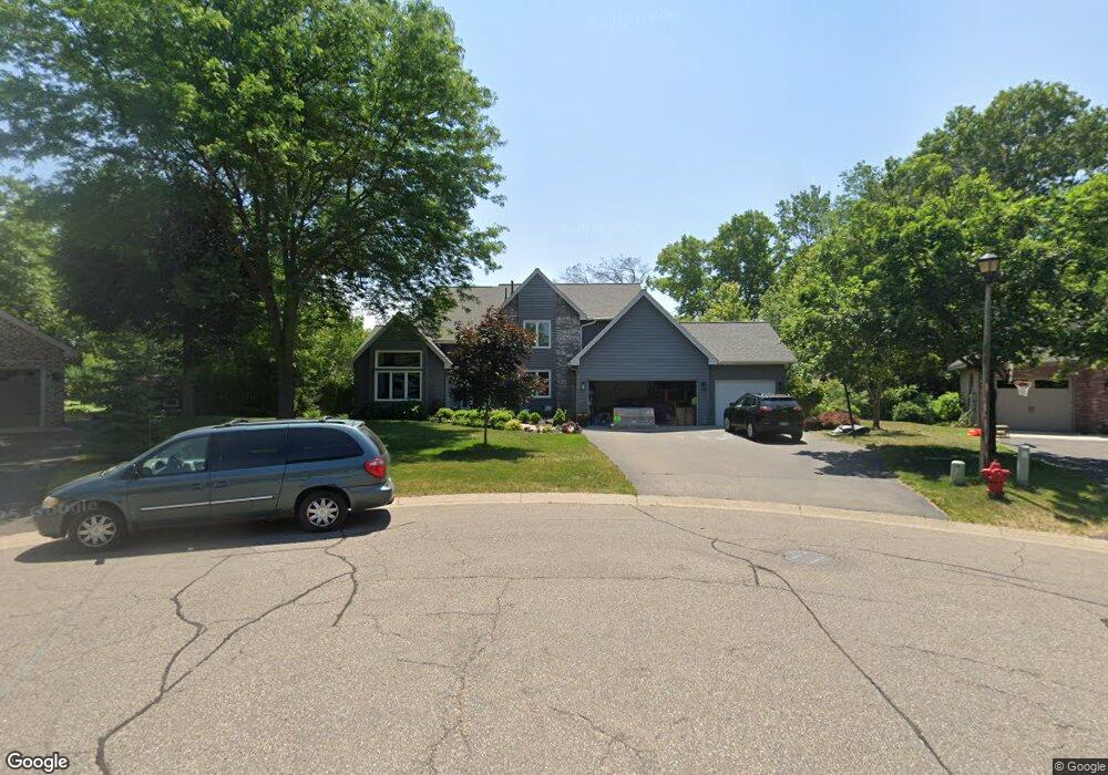
4760 Westminster Cir Saint Paul, MN 55122
Estimated Value: $639,000 - $743,000
5
Beds
4
Baths
2,695
Sq Ft
$253/Sq Ft
Est. Value
About This Home
This home is located at 4760 Westminster Cir, Saint Paul, MN 55122 and is currently estimated at $683,108, approximately $253 per square foot. 4760 Westminster Cir is a home located in Dakota County with nearby schools including Thomas Lake Elementary School, Falcon Ridge Middle School, and Eastview Senior High School.
Ownership History
Date
Name
Owned For
Owner Type
Purchase Details
Closed on
Apr 25, 2018
Sold by
Jensen Amy and Jensen Scott
Bought by
Nohelty Matthew and Nohelty Kelly
Current Estimated Value
Home Financials for this Owner
Home Financials are based on the most recent Mortgage that was taken out on this home.
Original Mortgage
$396,000
Outstanding Balance
$340,553
Interest Rate
4.44%
Mortgage Type
New Conventional
Estimated Equity
$342,555
Purchase Details
Closed on
Oct 14, 2003
Sold by
Scott James D and Scott Muriel E
Bought by
Gruhlke Robert T and Gruhlke Amy L
Create a Home Valuation Report for This Property
The Home Valuation Report is an in-depth analysis detailing your home's value as well as a comparison with similar homes in the area
Home Values in the Area
Average Home Value in this Area
Purchase History
| Date | Buyer | Sale Price | Title Company |
|---|---|---|---|
| Nohelty Matthew | $495,000 | Results Title | |
| Gruhlke Robert T | $363,000 | -- |
Source: Public Records
Mortgage History
| Date | Status | Borrower | Loan Amount |
|---|---|---|---|
| Open | Nohelty Matthew | $396,000 |
Source: Public Records
Tax History Compared to Growth
Tax History
| Year | Tax Paid | Tax Assessment Tax Assessment Total Assessment is a certain percentage of the fair market value that is determined by local assessors to be the total taxable value of land and additions on the property. | Land | Improvement |
|---|---|---|---|---|
| 2024 | $7,206 | $649,200 | $163,800 | $485,400 |
| 2023 | $7,206 | $638,400 | $162,900 | $475,500 |
| 2022 | $6,148 | $604,800 | $162,400 | $442,400 |
| 2021 | $5,722 | $539,700 | $141,200 | $398,500 |
| 2020 | $5,566 | $496,600 | $134,500 | $362,100 |
| 2019 | $5,042 | $470,000 | $128,100 | $341,900 |
| 2018 | $5,231 | $448,400 | $122,000 | $326,400 |
| 2017 | $5,094 | $449,900 | $116,200 | $333,700 |
| 2016 | $5,145 | $417,500 | $110,700 | $306,800 |
| 2015 | $5,095 | $418,000 | $110,700 | $307,300 |
| 2014 | -- | $420,900 | $107,700 | $313,200 |
| 2013 | -- | $372,164 | $96,806 | $275,358 |
Source: Public Records
Map
Nearby Homes
- 1517 Covington Ln
- 4731 Walden Dr
- 4633 Stonecliffe Dr
- 4628 Pinetree Curve
- XXXX Eriks Blvd
- 4765 Penkwe Cir
- 4681 Ridge Cliff Dr
- 4677 Ridge Cliff Dr
- 4646 1/2 Penkwe Way
- 1655 Walnut Ln
- 1719 Nokia Way
- 1676 Hickory Ln
- 1761 Karis Way
- 4679 Sorrel Point
- 1338 Ches Mar Ln
- 4694 Lenore Ln
- 4682 Lenore Ln
- 4714 Lenore Ln
- 1610 Clemson Dr
- 1778 Walnut Ln
- 4761 Westminster Cir
- 4744 Westminster Cir
- 4767 London Ln
- 4761 London Ln
- 4773 London Ln
- 4755 London Ln
- 4734 Westminster Cir
- 1528 Covington Ln
- 4747 Westminster Cir
- 1530 Covington Ln
- 4777 London Ln
- 4737 Westminster Cir
- 4730 Westminster Cir
- 4760 London Ln
- 4766 London Ln
- 4783 Beacon Hill Rd
- 4781 Beacon Hill Rd
- 4772 London Ln
- 4733 Westminster Cir
- 4785 Beacon Hill Rd