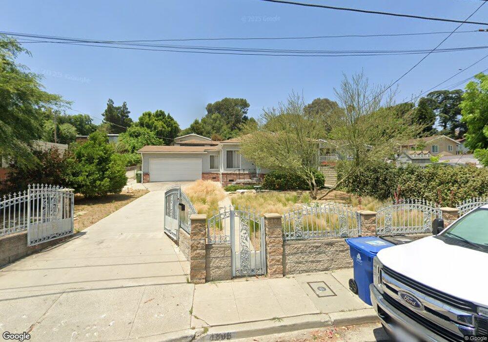
4806 Toland Way Los Angeles, CA 90042
Eagle Rock NeighborhoodEstimated Value: $838,414 - $1,061,000
2
Beds
1
Bath
874
Sq Ft
$1,089/Sq Ft
Est. Value
About This Home
This home is located at 4806 Toland Way, Los Angeles, CA 90042 and is currently estimated at $951,354, approximately $1,088 per square foot. 4806 Toland Way is a home located in Los Angeles County with nearby schools including Toland Way Elementary School, Benjamin Franklin High School, and Eagle Rock High School.
Ownership History
Date
Name
Owned For
Owner Type
Purchase Details
Closed on
Oct 1, 2018
Sold by
Tomlinson Daniel H and Tomlinson Sara
Bought by
Tomlinson Daniel H and Tomlinson Irrevocable Trust
Current Estimated Value
Purchase Details
Closed on
Sep 7, 2001
Sold by
Tomlinson Daniel H and Tomlinson Sara
Bought by
Tomlinson Daniel H and Tomlinson Sara
Purchase Details
Closed on
Feb 19, 1997
Sold by
Va
Bought by
Tomlinson Daniel H and Tomlinson Sara L
Create a Home Valuation Report for This Property
The Home Valuation Report is an in-depth analysis detailing your home's value as well as a comparison with similar homes in the area
Home Values in the Area
Average Home Value in this Area
Purchase History
| Date | Buyer | Sale Price | Title Company |
|---|---|---|---|
| Tomlinson Daniel H | -- | None Available | |
| Tomlinson Daniel H | -- | -- | |
| Tomlinson Daniel H | -- | -- |
Source: Public Records
Tax History Compared to Growth
Tax History
| Year | Tax Paid | Tax Assessment Tax Assessment Total Assessment is a certain percentage of the fair market value that is determined by local assessors to be the total taxable value of land and additions on the property. | Land | Improvement |
|---|---|---|---|---|
| 2025 | $751 | $46,723 | $12,473 | $34,250 |
| 2024 | $751 | $45,808 | $12,229 | $33,579 |
| 2023 | $740 | $44,911 | $11,990 | $32,921 |
| 2022 | $709 | $44,031 | $11,755 | $32,276 |
| 2021 | $697 | $43,169 | $11,525 | $31,644 |
| 2019 | $679 | $41,890 | $11,184 | $30,706 |
| 2018 | $536 | $41,069 | $10,965 | $30,104 |
| 2016 | $499 | $39,476 | $10,540 | $28,936 |
| 2015 | $492 | $38,884 | $10,382 | $28,502 |
| 2014 | $502 | $38,123 | $10,179 | $27,944 |
Source: Public Records
Map
Nearby Homes
- 4780 Hub St
- 4824 Toland Way
- 1336 Armadale Ave
- 4654 Toland Way
- 4854 Buchanan St
- 1017 Dexter St
- 925 927 El Paso Dr
- 4500 Mont Eagle Place
- 4925 Buchanan St
- 1048 Dexter St
- 1113 N Avenue 50
- 4666 York Blvd
- 1037 N Avenue 50
- 1087 Oneonta Dr
- 1127 Oneonta Dr
- 4312 Division St
- 865 N Avenue 50
- 4844 San Rafael Ave
- 917 N Avenue 51
- 5055 Hub St
- 4816 Toland Way
- 4810 Toland Way
- 4808 Toland Way
- 4807 Toland Way
- 4803 Toland Way
- 4820 Toland Way
- 4811 Toland Way
- 4770 Toland Way
- 4757 Mendota Ave
- 4777 Toland Way
- 4700 Baltimore St
- 4834 Toland Way
- 4817 Toland Way
- 4764 Toland Way
- 4759 Mendota Ave
- 0 Baltimore St
- 4825 Toland Way
- 4771 Toland Way
- 4838 Toland Way
- 4763 Mendota Ave