Estimated Value: $260,000 - $310,000
4
Beds
3
Baths
820
Sq Ft
$347/Sq Ft
Est. Value
About This Home
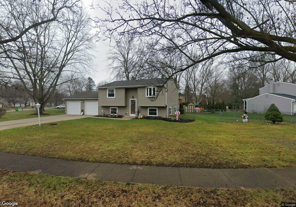
This home is located at 4899 Algonquin Trail, Stow, OH 44224 and is currently estimated at $284,900, approximately $347 per square foot. 4899 Algonquin Trail is a home located in Summit County with nearby schools including Stow-Munroe Falls High School, Primrose School of Hudson, and Cuyahoga Valley Christian Academy.
Ownership History
Date
Name
Owned For
Owner Type
Purchase Details
Closed on
Apr 17, 2007
Sold by
Leader Alan
Bought by
Tirpak Gail A
Current Estimated Value
Home Financials for this Owner
Home Financials are based on the most recent Mortgage that was taken out on this home.
Original Mortgage
$108,000
Outstanding Balance
$64,140
Interest Rate
6.19%
Mortgage Type
Purchase Money Mortgage
Estimated Equity
$220,760
Create a Home Valuation Report for This Property
The Home Valuation Report is an in-depth analysis detailing your home's value as well as a comparison with similar homes in the area
Home Values in the Area
Average Home Value in this Area
Purchase History
| Date | Buyer | Sale Price | Title Company |
|---|---|---|---|
| Tirpak Gail A | $135,000 | Titlemax Agency Llc |
Source: Public Records
Mortgage History
| Date | Status | Borrower | Loan Amount |
|---|---|---|---|
| Open | Tirpak Gail A | $108,000 |
Source: Public Records
Tax History
| Year | Tax Paid | Tax Assessment Tax Assessment Total Assessment is a certain percentage of the fair market value that is determined by local assessors to be the total taxable value of land and additions on the property. | Land | Improvement |
|---|---|---|---|---|
| 2025 | $4,256 | $73,983 | $13,447 | $60,536 |
| 2024 | $4,256 | $73,983 | $13,447 | $60,536 |
| 2023 | $4,256 | $73,983 | $13,447 | $60,536 |
| 2022 | $3,732 | $57,086 | $10,343 | $46,743 |
| 2021 | $3,351 | $57,086 | $10,343 | $46,743 |
| 2020 | $3,295 | $57,080 | $10,340 | $46,740 |
| 2019 | $3,089 | $49,890 | $9,240 | $40,650 |
| 2018 | $2,907 | $47,600 | $9,240 | $38,360 |
| 2017 | $2,664 | $47,600 | $9,240 | $38,360 |
| 2016 | $2,739 | $42,210 | $9,240 | $32,970 |
| 2015 | $2,664 | $42,210 | $9,240 | $32,970 |
| 2014 | $2,666 | $42,210 | $9,240 | $32,970 |
| 2013 | $2,194 | $34,560 | $9,240 | $25,320 |
Source: Public Records
Map
Nearby Homes
- 0 Hibbard Dr
- V/L Housley Rd
- 1525 Spruce Hill Dr
- 4704 Red Willow Rd
- 4623 Cox Dr
- 1514 & 1516 Robin Ln
- 5123 Sodalite Dr
- 1620 Sapphire Dr
- 1961 Arndale Rd
- 2279 Becket Cir
- 5091 Ridge Meadow Dr
- V/L Diplomat Dr
- 1353 Berkshire Rd
- 4424 Timberdale Dr Unit 4428
- 734 Barlow Rd
- V/L Norton Rd
- 2072 White Oak Dr Unit 2076
- 2221 Crockett Cir
- 3792 Baumberger Rd Unit 3796
- 5163 Beckett Ridge
- 4887 Algonquin Trail
- 4921 Algonquin Trail
- 4750 Southbrook Dr
- 4906 Algonquin Trail
- 4898 Algonquin Trail
- 4877 Algonquin Trail
- 4920 Algonquin Trail
- 4914 Algonquin Trail
- 4884 Algonquin Trail
- 4928 Algonquin Trail
- 4740 Southbrook Dr
- 4955 Commanche Trail
- 4876 Algonquin Trail
- 4867 Algonquin Trail
- 4739 Southbrook Dr
- 4948 Commanche Trail
- 4868 Algonquin Trail
- 4749 Southbrook Dr
- 4885 Hudson Dr
- 1315 Cherokee Trail
Your Personal Tour Guide
Ask me questions while you tour the home.