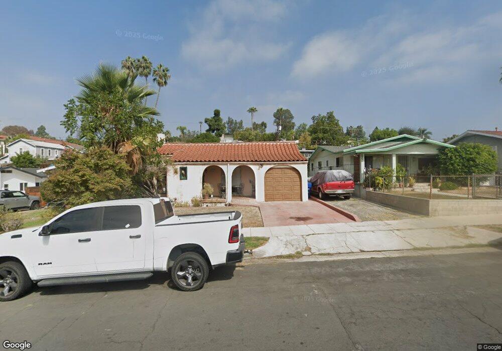
4929 Stratford Rd Los Angeles, CA 90042
Estimated Value: $1,115,000 - $1,465,000
3
Beds
1
Bath
1,545
Sq Ft
$847/Sq Ft
Est. Value
About This Home
This home is located at 4929 Stratford Rd, Los Angeles, CA 90042 and is currently estimated at $1,308,084, approximately $846 per square foot. 4929 Stratford Rd is a home located in Los Angeles County with nearby schools including Buchanan Street Elementary, Benjamin Franklin High School, and Luther Burbank Middle School.
Ownership History
Date
Name
Owned For
Owner Type
Purchase Details
Closed on
Oct 28, 1993
Sold by
Saenz Carlos A and Saenz Cindi S
Bought by
Walsh Thomas
Current Estimated Value
Home Financials for this Owner
Home Financials are based on the most recent Mortgage that was taken out on this home.
Original Mortgage
$150,750
Interest Rate
7.09%
Create a Home Valuation Report for This Property
The Home Valuation Report is an in-depth analysis detailing your home's value as well as a comparison with similar homes in the area
Home Values in the Area
Average Home Value in this Area
Purchase History
| Date | Buyer | Sale Price | Title Company |
|---|---|---|---|
| Walsh Thomas | $167,500 | Guardian Title |
Source: Public Records
Mortgage History
| Date | Status | Borrower | Loan Amount |
|---|---|---|---|
| Previous Owner | Walsh Thomas | $150,750 |
Source: Public Records
Tax History Compared to Growth
Tax History
| Year | Tax Paid | Tax Assessment Tax Assessment Total Assessment is a certain percentage of the fair market value that is determined by local assessors to be the total taxable value of land and additions on the property. | Land | Improvement |
|---|---|---|---|---|
| 2025 | $3,505 | $284,663 | $172,331 | $112,332 |
| 2024 | $3,505 | $279,082 | $168,952 | $110,130 |
| 2023 | $3,439 | $273,611 | $165,640 | $107,971 |
| 2022 | $3,280 | $268,247 | $162,393 | $105,854 |
| 2021 | $3,232 | $262,988 | $159,209 | $103,779 |
| 2020 | $3,260 | $260,292 | $157,577 | $102,715 |
| 2019 | $3,135 | $255,189 | $154,488 | $100,701 |
| 2018 | $3,074 | $250,186 | $151,459 | $98,727 |
| 2016 | $2,922 | $240,474 | $145,579 | $94,895 |
| 2015 | $2,879 | $236,863 | $143,393 | $93,470 |
| 2014 | $2,894 | $232,225 | $140,585 | $91,640 |
Source: Public Records
Map
Nearby Homes
- 5117 Stratford Rd
- 4925 Buchanan St
- 1113 N Avenue 50
- 4854 Buchanan St
- 5125 Buchanan St
- 1048 Dexter St
- 1336 Armadale Ave
- 1037 N Avenue 50
- 5252 Range View Ave
- 1902 N Avenue 51
- 5055 Hub St
- 1813 N Avenue 53
- 4666 York Blvd
- 4780 Hub St
- 5240 Barker Dr
- 1915 N Avenue 52
- 1932 Phillips Way
- 4707 Toland Way
- 1942 Phillips Way
- 1607 Campus Rd
- 4925 Stratford Rd
- 4933 Stratford Rd
- 4921 Stratford Rd
- 4937 Stratford Rd
- 4923 Stratford Rd
- 4917 Stratford Rd
- 4941 Stratford Rd
- 4930 Range View Ave
- 4926 Range View Ave
- 4934 Range View Ave
- 4938 Range View Ave
- 4922 Range View Ave
- 4945 Strafford Rd
- 4945 Stratford Rd
- 4913 Stratford Rd
- 4918 Range View Ave
- 4936 Stratford Rd
- 4928 Stratford Rd
- 4942 Range View Ave
- 4924 Stratford Rd