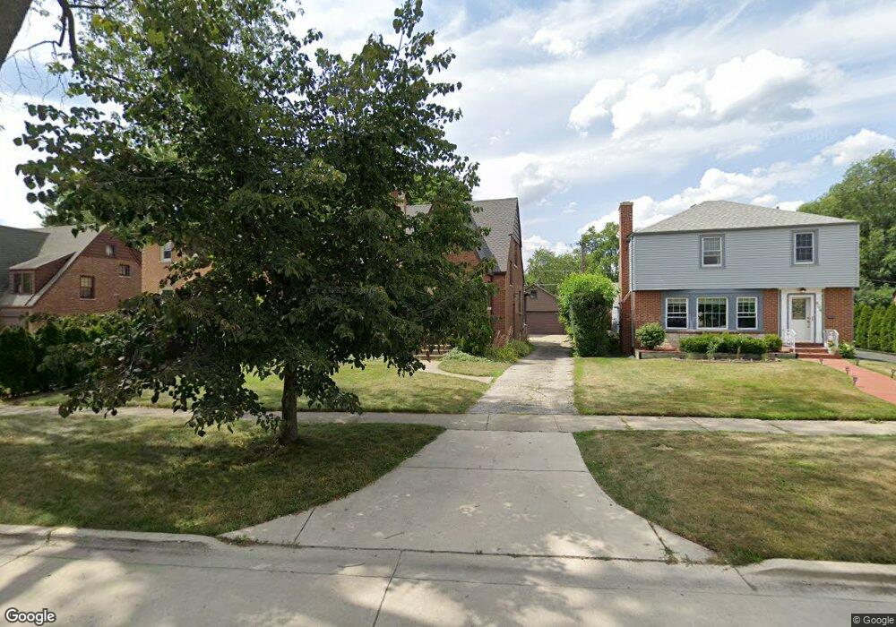
500 Kent Rd Riverside, IL 60546
Estimated Value: $427,000 - $603,000
3
Beds
2
Baths
1,429
Sq Ft
$346/Sq Ft
Est. Value
About This Home
This home is located at 500 Kent Rd, Riverside, IL 60546 and is currently estimated at $493,723, approximately $345 per square foot. 500 Kent Rd is a home located in Cook County with nearby schools including Blythe Park Elementary School, L J Hauser Jr High School, and Riverside Brookfield High School.
Ownership History
Date
Name
Owned For
Owner Type
Purchase Details
Closed on
Oct 19, 2023
Sold by
Catherine V Frank 2003 Trust
Bought by
Frank Erinn Elizabeth and Frank Elise Michelle
Current Estimated Value
Purchase Details
Closed on
Mar 29, 2021
Sold by
Frank Steven E and Frank Catherine V
Bought by
Frank Catherine V and Catherine V Frank 2003 Trust
Purchase Details
Closed on
Aug 4, 1993
Sold by
Virgilio Nick R and Virgilio Grace L
Bought by
Frank Steven E and Frank Catherine V
Home Financials for this Owner
Home Financials are based on the most recent Mortgage that was taken out on this home.
Original Mortgage
$162,000
Interest Rate
7.22%
Create a Home Valuation Report for This Property
The Home Valuation Report is an in-depth analysis detailing your home's value as well as a comparison with similar homes in the area
Home Values in the Area
Average Home Value in this Area
Purchase History
| Date | Buyer | Sale Price | Title Company |
|---|---|---|---|
| Frank Erinn Elizabeth | -- | None Listed On Document | |
| Frank Catherine V | -- | Amrock Inc | |
| Frank Steven E | $120,000 | -- |
Source: Public Records
Mortgage History
| Date | Status | Borrower | Loan Amount |
|---|---|---|---|
| Previous Owner | Frank Steven E | $162,000 |
Source: Public Records
Tax History
| Year | Tax Paid | Tax Assessment Tax Assessment Total Assessment is a certain percentage of the fair market value that is determined by local assessors to be the total taxable value of land and additions on the property. | Land | Improvement |
|---|---|---|---|---|
| 2025 | $9,935 | $34,372 | $6,600 | $27,772 |
| 2024 | $9,935 | $34,372 | $6,600 | $27,772 |
| 2023 | $9,151 | $34,372 | $6,600 | $27,772 |
| 2022 | $9,151 | $27,311 | $5,775 | $21,536 |
| 2021 | $8,826 | $27,310 | $5,775 | $21,535 |
| 2020 | $9,376 | $29,439 | $5,775 | $23,664 |
| 2019 | $5,857 | $20,070 | $5,280 | $14,790 |
| 2018 | $5,683 | $20,070 | $5,280 | $14,790 |
| 2017 | $7,260 | $25,338 | $5,280 | $20,058 |
| 2016 | $7,587 | $24,040 | $4,620 | $19,420 |
| 2015 | $7,370 | $24,040 | $4,620 | $19,420 |
| 2014 | $7,742 | $25,460 | $4,620 | $20,840 |
| 2013 | $6,769 | $24,326 | $4,620 | $19,706 |
Source: Public Records
Map
Nearby Homes
- 478 Kent Rd
- 2817 Maple Ave
- 562 Byrd Rd
- 571 Byrd Rd
- 484 Shenstone Rd
- 2816 Wenonah Ave
- 475 Shenstone Rd Unit 104
- 475 Shenstone Rd Unit 304
- 475 Shenstone Rd Unit 303
- 2817 Wenonah Ave
- 3111 Wenonah Ave
- 369 Addison Rd
- 6840 29th Place
- 2532 Clinton Ave
- 2728 Grove Ave
- 2716 Grove Ave
- 6828 30th Place
- 269 Shenstone Rd
- 2508 Kenilworth Ave
- 3031 Oak Park Ave
- 504 Kent Rd
- 494 Kent Rd
- 492 Kent Rd
- 508 Kent Rd
- 490 Kent Rd
- 495 Longcommon Rd
- 491 Longcommon Rd
- 499 Kent Rd
- 487 Longcommon Rd
- 484 Kent Rd
- 2904 Harlem Ave
- 483 Longcommon Rd
- 680 Selborne Rd
- 507 Longcommon Rd
- 479 Longcommon Rd
- 684 Selborne Rd
- 511 Longcommon Rd
- 2916 S Harlem Ave
- 515 Longcommon Rd
- 2922 Harlem Ave Unit 3
Your Personal Tour Guide
Ask me questions while you tour the home.