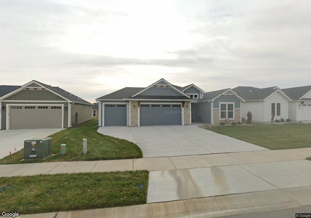
5013 Cedar Grove Way Lawrence, KS 66049
West Lawrence NeighborhoodEstimated Value: $484,114 - $531,000
3
Beds
2
Baths
1,850
Sq Ft
$274/Sq Ft
Est. Value
About This Home
This home is located at 5013 Cedar Grove Way, Lawrence, KS 66049 and is currently estimated at $506,529, approximately $273 per square foot. 5013 Cedar Grove Way is a home located in Douglas County with nearby schools including Langston Hughes Elementary School, Southwest Middle School, and Lawrence Free State High School.
Ownership History
Date
Name
Owned For
Owner Type
Purchase Details
Closed on
Sep 19, 2024
Sold by
Sharon Kay Thiel Revocable Living Trust
Bought by
Lang Marsha J
Current Estimated Value
Purchase Details
Closed on
Jul 25, 2023
Sold by
Thiel Sharon Kay
Bought by
Sharon Kay Thiel Revocable Living Trust and Thiel
Purchase Details
Closed on
May 24, 2022
Sold by
Landstar Development Lc
Bought by
Thiel Sharon Kay
Purchase Details
Closed on
Apr 7, 2022
Sold by
We1929 Llc
Bought by
Landstar Development Lc
Create a Home Valuation Report for This Property
The Home Valuation Report is an in-depth analysis detailing your home's value as well as a comparison with similar homes in the area
Home Values in the Area
Average Home Value in this Area
Purchase History
| Date | Buyer | Sale Price | Title Company |
|---|---|---|---|
| Lang Marsha J | -- | Continental Title | |
| Sharon Kay Thiel Revocable Living Trust | -- | None Listed On Document | |
| Thiel Sharon Kay | -- | Security 1St Title | |
| Landstar Development Lc | -- | Kansas Secured Title |
Source: Public Records
Tax History Compared to Growth
Tax History
| Year | Tax Paid | Tax Assessment Tax Assessment Total Assessment is a certain percentage of the fair market value that is determined by local assessors to be the total taxable value of land and additions on the property. | Land | Improvement |
|---|---|---|---|---|
| 2025 | $6,832 | $54,625 | $9,200 | $45,425 |
| 2024 | $7,049 | $56,281 | $8,625 | $47,656 |
| 2023 | $6,838 | $52,889 | $8,050 | $44,839 |
| 2022 | $1,109 | $8,400 | $8,400 | $0 |
| 2021 | $1,102 | $8,160 | $8,160 | $0 |
| 2020 | $1,048 | $7,798 | $7,798 | $0 |
| 2019 | $1,208 | $9,000 | $9,000 | $0 |
| 2018 | $8 | $0 | $0 | $0 |
Source: Public Records
Map
Nearby Homes
- 5024 Cedar Grove Way
- 1202 Little Knife
- 5117 Harvard Rd
- 1300 Research Park Dr
- 904 Moundridge Dr
- 1315 Research Park Dr
- 5204 Foxchase Dr
- 5204 Fox Chase Dr
- 1040 Stonecreek Dr
- 1017 Stoneridge Dr
- 1033 Stonecreek Dr
- 5245 Overland Dr Unit A15
- 5245 Overland Dr Unit C12
- 5245 Overland Dr Unit D4
- 1347 Kanza Dr
- 1204 Chadwick Ct
- 1012 Wagon Wheel Rd
- 1601 Research Park Dr
- 1113 Somerset Cir
- 5710 Goff Ct
- 5009 Cedar Grove Way
- 5012 Spruce St
- 5021 Cedar Grove Way
- 5016 Cedar Grove Way
- 5020 Spruce St
- 5008 Cedar Grove Way
- 5009 Spruce St
- 5013 Spruce St
- 5101 Cedar Grove Way
- 5100 Spruce St
- 5004 Cedar Grove Way
- 5005 Spruce St
- 5017 Spruce St
- 5105 Cedar Grove Way
- 5104 Spruce St
- 5000 Cedar Grove Way
- 1017 Columbine Ct
- 1016 Congressional Ct
- 1013 Columbine Ct
- 1113 Biltmore Dr