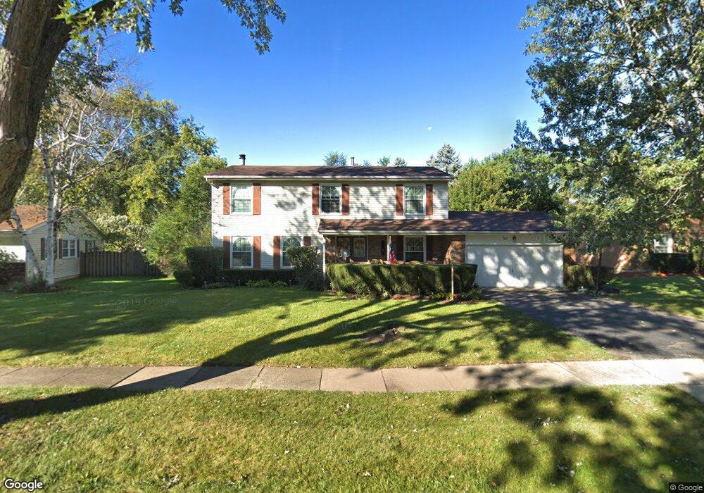
511 Skyline Dr Algonquin, IL 60102
Estimated Value: $378,331 - $445,000
Studio
1
Bath
2,132
Sq Ft
$198/Sq Ft
Est. Value
About This Home
This home is located at 511 Skyline Dr, Algonquin, IL 60102 and is currently estimated at $423,083, approximately $198 per square foot. 511 Skyline Dr is a home located in McHenry County with nearby schools including Westfield Community School, Kenneth E Neubert Elementary School, and Harry D Jacobs High School.
Ownership History
Date
Name
Owned For
Owner Type
Purchase Details
Closed on
Sep 28, 2004
Sold by
Berry Thomas A
Bought by
Berry Ellen D
Current Estimated Value
Purchase Details
Closed on
Jun 16, 2000
Sold by
Secund Nils R and Secund Marjorie A
Bought by
Berry Thomas A and Berry Ellen D
Home Financials for this Owner
Home Financials are based on the most recent Mortgage that was taken out on this home.
Original Mortgage
$174,847
Outstanding Balance
$63,483
Interest Rate
8.64%
Mortgage Type
FHA
Estimated Equity
$359,600
Create a Home Valuation Report for This Property
The Home Valuation Report is an in-depth analysis detailing your home's value as well as a comparison with similar homes in the area
Purchase History
| Date | Buyer | Sale Price | Title Company |
|---|---|---|---|
| Berry Ellen D | -- | -- | |
| Berry Thomas A | $190,000 | -- |
Source: Public Records
Mortgage History
| Date | Status | Borrower | Loan Amount |
|---|---|---|---|
| Open | Berry Thomas A | $174,847 |
Source: Public Records
Tax History
| Year | Tax Paid | Tax Assessment Tax Assessment Total Assessment is a certain percentage of the fair market value that is determined by local assessors to be the total taxable value of land and additions on the property. | Land | Improvement |
|---|---|---|---|---|
| 2024 | $8,289 | $113,966 | $24,922 | $89,044 |
| 2023 | $7,863 | $101,929 | $22,290 | $79,639 |
| 2022 | $7,555 | $94,098 | $22,013 | $72,085 |
| 2021 | $7,246 | $87,664 | $20,508 | $67,156 |
| 2020 | $7,054 | $84,561 | $19,782 | $64,779 |
| 2019 | $6,881 | $80,935 | $18,934 | $62,001 |
| 2018 | $6,555 | $74,767 | $17,491 | $57,276 |
| 2017 | $6,417 | $70,436 | $16,478 | $53,958 |
| 2016 | $6,316 | $66,063 | $15,455 | $50,608 |
| 2013 | -- | $55,448 | $14,417 | $41,031 |
Source: Public Records
Map
Nearby Homes
- 730 Chestnut Ct
- 615 Harper Dr
- 21 Division St
- 407 La Fox River Dr
- 1200 Hillside View
- 0 River Dr N Unit MRD12473279
- Lot #3-5 Hayes Rd
- 1 N Hubbard St
- SWC Talaga and Algonquin Rd
- 720 Ash St
- 13 Brian Ct
- 909 Roger St
- 1354 Essex St Unit 2
- 600 E Algonquin Rd
- 1431 Essex St
- 700 Fairfield Ln
- 966 Mesa Dr
- 308 Rustic Ln
- 935 Viewpoint Dr
- 719 Webster St
- 513 Skyline Dr
- 509 Skyline Dr
- 602 Evergreen Ct
- 601 Evergreen Ct
- 506 Skyline Dr
- 605 Mulberry Ct Unit 1
- 515 Skyline Dr
- 610 Huntington Ct Unit 1
- 507 Skyline Dr
- 615 Mulberry Ct
- 504 Skyline Dr
- 611 Evergreen Ct
- 514 Skyline Dr
- 612 Evergreen Ct
- 519 Skyline Dr
- 605 Huntington Ct
- 600 Mulberry Ct
- 505 Skyline Dr
- 620 Huntington Ct Unit 1
- 625 Mulberry Ct
Your Personal Tour Guide
Ask me questions while you tour the home.