Estimated Value: $258,425 - $304,000
3
Beds
3
Baths
1,342
Sq Ft
$210/Sq Ft
Est. Value
About This Home
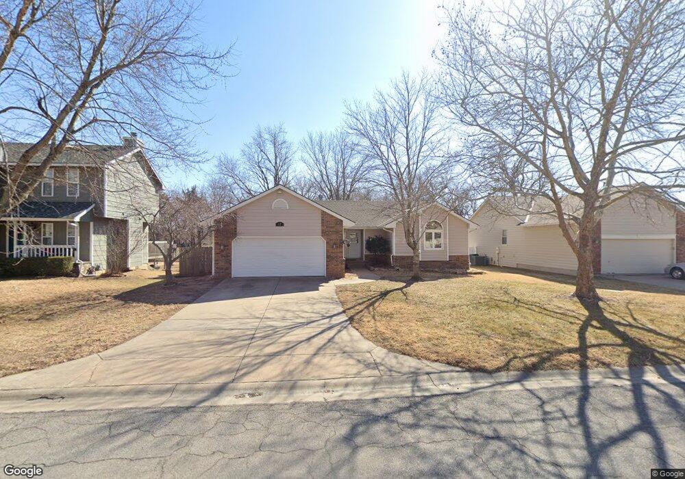
This home is located at 517 Conestoga Rd, Maize, KS 67101 and is currently estimated at $281,213, approximately $209 per square foot. 517 Conestoga Rd is a home located in Sedgwick County with nearby schools including Maize Middle School and Maize High School.
Ownership History
Date
Name
Owned For
Owner Type
Purchase Details
Closed on
Feb 9, 2026
Sold by
Barnes Edmund L and Barnes Nancy C
Bought by
Barnes William B
Current Estimated Value
Purchase Details
Closed on
Jun 10, 2024
Sold by
Barnes Edmund L and Barnes Nancy C
Bought by
Barnes Edmund L and Barnes Nancy C
Purchase Details
Closed on
Sep 20, 2000
Sold by
Dickman Joanne C
Bought by
Barnes Edmund L and Barnes Nancy C
Home Financials for this Owner
Home Financials are based on the most recent Mortgage that was taken out on this home.
Original Mortgage
$30,000
Interest Rate
8.01%
Create a Home Valuation Report for This Property
The Home Valuation Report is an in-depth analysis detailing your home's value as well as a comparison with similar homes in the area
Home Values in the Area
Average Home Value in this Area
Purchase History
| Date | Buyer | Sale Price | Title Company |
|---|---|---|---|
| Barnes William B | -- | Accommodation/Courtesy Recordi | |
| Barnes Edmund L | -- | -- | |
| Barnes Edmund L | -- | Columbian Natl Title Ins Co |
Source: Public Records
Mortgage History
| Date | Status | Borrower | Loan Amount |
|---|---|---|---|
| Previous Owner | Barnes Edmund L | $30,000 |
Source: Public Records
Tax History
| Year | Tax Paid | Tax Assessment Tax Assessment Total Assessment is a certain percentage of the fair market value that is determined by local assessors to be the total taxable value of land and additions on the property. | Land | Improvement |
|---|---|---|---|---|
| 2025 | $3,917 | $29,072 | $5,336 | $23,736 |
| 2023 | $3,917 | $24,312 | $4,244 | $20,068 |
| 2022 | $3,320 | $21,977 | $4,002 | $17,975 |
| 2021 | $3,068 | $20,160 | $2,737 | $17,423 |
| 2020 | $2,888 | $19,021 | $2,737 | $16,284 |
| 2019 | $2,691 | $17,779 | $2,737 | $15,042 |
| 2018 | $2,545 | $16,767 | $2,139 | $14,628 |
| 2017 | $2,459 | $0 | $0 | $0 |
| 2016 | $2,383 | $0 | $0 | $0 |
| 2015 | -- | $0 | $0 | $0 |
| 2014 | -- | $0 | $0 | $0 |
Source: Public Records
Map
Nearby Homes
- 721 High Plains Cir
- 415 S Sweetwater Rd
- 432 S Sweetwater Rd
- 403 S Sweetwater Rd
- 429 S Longbranch Dr
- 613 S Sweetwater Cir
- 319 Jonathan St
- 634 S Sweetwater Rd
- 903 Stetson Cir
- 9658 W Cedar Ln
- 9657 W Cedar Ln
- 10494 W Wilkinson St
- 10498 W Wilkinson St
- 628 S Longbranch Dr
- 10530 W Wilkinson St
- 9630 W Cedar Ln
- 9637 W Cedar Ln
- 4456 N Bluestem St
- 729 S Longbranch Dr
- 10696 Sondra
- 523 Conestoga Rd
- 509 Conestoga Rd
- 531 Conestoga Rd
- 516 Conestoga Rd
- 522 Conestoga Rd
- 508 Conestoga Rd
- 530 Conestoga Rd
- 607 Conestoga Rd
- 606 E Conestoga
- 600 High Plains Cir
- 600 High Plains Cir
- 4825 N Maize Rd
- 606 Conestoga Rd
- 4746 N Maize Rd
- 615 Conestoga Rd
- 4845 N Maize Rd
- 608 High Plains Cir
- 614 Conestoga Rd
- 420 E Irma St
- 621 Conestoga Rd
Your Personal Tour Guide
Ask me questions while you tour the home.