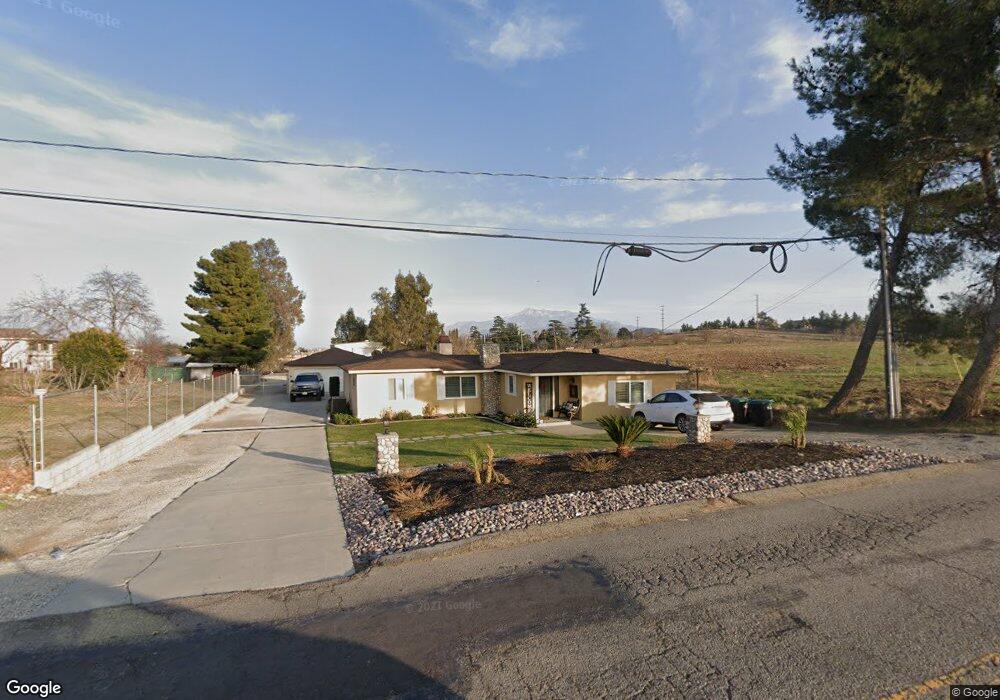
52 Michigan Ave Beaumont, CA 92223
Estimated Value: $418,000 - $496,000
3
Beds
2
Baths
1,835
Sq Ft
$252/Sq Ft
Est. Value
About This Home
This home is located at 52 Michigan Ave, Beaumont, CA 92223 and is currently estimated at $462,658, approximately $252 per square foot. 52 Michigan Ave is a home located in Riverside County with nearby schools including Three Rings Ranch Elementary School, Mountain View Middle School, and Beaumont Senior High School.
Ownership History
Date
Name
Owned For
Owner Type
Purchase Details
Closed on
Sep 20, 2017
Sold by
Kinkyl Corp
Bought by
Brisbin Donald W and Brisbin Elizabeth J
Current Estimated Value
Purchase Details
Closed on
Jan 7, 2016
Sold by
Brisbin Donald W and Brisbin Elizabeth J
Bought by
Kinkyl Corporation
Purchase Details
Closed on
May 9, 1994
Sold by
Smith Robert E and Smith Nelda
Bought by
Brisbin Donald W and Brisbin Elizabeth J
Home Financials for this Owner
Home Financials are based on the most recent Mortgage that was taken out on this home.
Original Mortgage
$114,000
Interest Rate
8.6%
Create a Home Valuation Report for This Property
The Home Valuation Report is an in-depth analysis detailing your home's value as well as a comparison with similar homes in the area
Home Values in the Area
Average Home Value in this Area
Purchase History
| Date | Buyer | Sale Price | Title Company |
|---|---|---|---|
| Brisbin Donald W | -- | None Available | |
| Kinkyl Corporation | -- | None Available | |
| Brisbin Donald W | $120,000 | Gateway Title Company |
Source: Public Records
Mortgage History
| Date | Status | Borrower | Loan Amount |
|---|---|---|---|
| Previous Owner | Brisbin Donald W | $114,000 |
Source: Public Records
Tax History
| Year | Tax Paid | Tax Assessment Tax Assessment Total Assessment is a certain percentage of the fair market value that is determined by local assessors to be the total taxable value of land and additions on the property. | Land | Improvement |
|---|---|---|---|---|
| 2025 | $2,225 | $169,927 | $33,972 | $135,955 |
| 2023 | $2,225 | $163,330 | $32,653 | $130,677 |
| 2022 | $2,191 | $160,128 | $32,013 | $128,115 |
| 2021 | $2,150 | $156,989 | $31,386 | $125,603 |
| 2020 | $2,127 | $155,381 | $31,065 | $124,316 |
| 2019 | $2,094 | $152,335 | $30,456 | $121,879 |
| 2018 | $2,085 | $149,349 | $29,860 | $119,489 |
| 2017 | $2,052 | $146,422 | $29,275 | $117,147 |
| 2016 | $1,904 | $143,551 | $28,701 | $114,850 |
| 2015 | $1,871 | $141,397 | $28,271 | $113,126 |
| 2014 | $1,870 | $138,629 | $27,718 | $110,911 |
Source: Public Records
Map
Nearby Homes
- 73 Berkshire Ave
- 115 Festive Ct
- 1353 Fleet St
- 64 Graham St
- 59 Helen Ave
- 130 Boston Ave
- 117 Temple Ave
- 208 Dwyer Ave
- 525 Palm Ave Unit 30
- 1257 E 6th St
- 1486 Signal Peak
- 612 Pennsylvania Ave
- 283 White Sands St
- 1490 Flamingo St
- 113 Owl Creek
- 713 Michigan Ave
- 1457 Faircliff St
- 734 Massachusetts Ave
- 207 E 5th St
- 743 American Ave
- 74 Michigan Ave
- 86 Michigan Ave
- 1051 E 1st St
- 1001 E 1st St
- 1071 E 1st St
- 909 E First St
- 15 Michigan Ave
- 909 Ist St
- 0 Michigan Ave Unit I08132199
- 0 Michigan Ave Unit E11036942
- 0 Michigan Ave Unit E11143542
- 0 Michigan Ave Unit E12048922
- 0 Michigan Ave Unit EV16066821
- 0 Michigan Ave Unit EV17188937
- 0 Michigan Ave Unit IV24079393
- 0 Michigan Ave Unit EV20173358
- 1 Manzanita Rd
- 0 Manzanita Rd
- 0 Manzanita Rd Unit 20-592406
- 0 Manzanita Rd Unit 12-593915
Your Personal Tour Guide
Ask me questions while you tour the home.