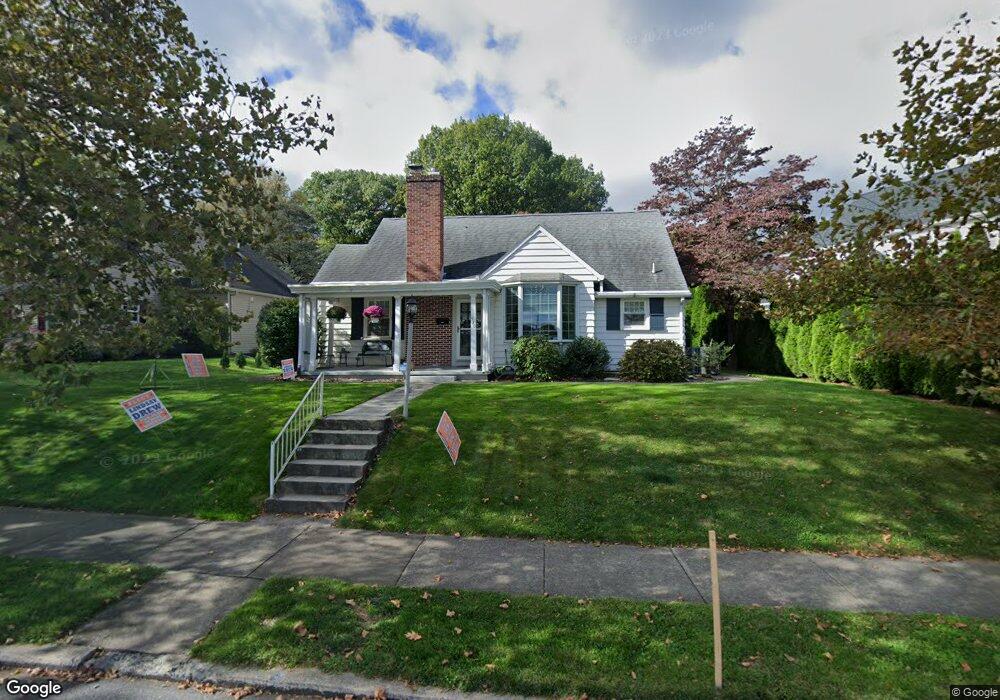
520 Cocoa Ave Hershey, PA 17033
Estimated Value: $440,492 - $613,000
3
Beds
2
Baths
1,895
Sq Ft
$272/Sq Ft
Est. Value
About This Home
This home is located at 520 Cocoa Ave, Hershey, PA 17033 and is currently estimated at $515,123, approximately $271 per square foot. 520 Cocoa Ave is a home located in Dauphin County with nearby schools including Hershey Elementary School, Hershey Primary Elementary School, and Hershey Middle School.
Ownership History
Date
Name
Owned For
Owner Type
Purchase Details
Closed on
Jul 21, 2017
Sold by
Kray Charles C and Kray Sara C
Bought by
Gifford Lisa K and Coulter Matthew S
Current Estimated Value
Home Financials for this Owner
Home Financials are based on the most recent Mortgage that was taken out on this home.
Original Mortgage
$260,000
Outstanding Balance
$216,016
Interest Rate
3.89%
Mortgage Type
New Conventional
Estimated Equity
$299,107
Create a Home Valuation Report for This Property
The Home Valuation Report is an in-depth analysis detailing your home's value as well as a comparison with similar homes in the area
Home Values in the Area
Average Home Value in this Area
Purchase History
| Date | Buyer | Sale Price | Title Company |
|---|---|---|---|
| Gifford Lisa K | $300,000 | None Available |
Source: Public Records
Mortgage History
| Date | Status | Borrower | Loan Amount |
|---|---|---|---|
| Open | Gifford Lisa K | $260,000 |
Source: Public Records
Tax History Compared to Growth
Tax History
| Year | Tax Paid | Tax Assessment Tax Assessment Total Assessment is a certain percentage of the fair market value that is determined by local assessors to be the total taxable value of land and additions on the property. | Land | Improvement |
|---|---|---|---|---|
| 2025 | $3,850 | $123,200 | $34,200 | $89,000 |
| 2024 | $3,619 | $123,200 | $34,200 | $89,000 |
| 2023 | $3,554 | $123,200 | $34,200 | $89,000 |
| 2022 | $3,475 | $123,200 | $34,200 | $89,000 |
| 2021 | $3,475 | $123,200 | $34,200 | $89,000 |
| 2020 | $3,475 | $123,200 | $34,200 | $89,000 |
| 2019 | $3,413 | $123,200 | $34,200 | $89,000 |
| 2018 | $3,322 | $123,200 | $34,200 | $89,000 |
| 2017 | $3,322 | $123,200 | $34,200 | $89,000 |
| 2016 | $0 | $123,200 | $34,200 | $89,000 |
| 2015 | -- | $123,200 | $34,200 | $89,000 |
| 2014 | -- | $123,200 | $34,200 | $89,000 |
Source: Public Records
Map
Nearby Homes
- 118 Elm Ave
- 124 Maple Ave
- 229 Cocoa Ave
- 310 W Caracas Ave
- 29 Almond Dr
- 324 E Areba Ave
- 406 W Caracas Ave
- 425 W Caracas Ave
- 519 Cedar Ave
- 81 Locust Ave
- 520 W Caracas Ave
- 571 Beech Ave
- 308 E Derry Rd
- 228 Hockersville Rd
- 72 Leearden Rd
- 32 Cambridge Dr
- 104 Cambridge Dr
- 1030 Beech Ave
- 49 Sylvania Rd
- 0 Stauffers Church Rd Unit PADA2052308