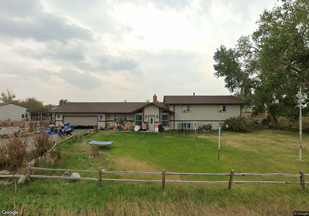
5208 Yeoman Rd Shepherd, MT 59079
Estimated Value: $478,000 - $514,000
5
Beds
4
Baths
3,148
Sq Ft
$158/Sq Ft
Est. Value
About This Home
This home is located at 5208 Yeoman Rd, Shepherd, MT 59079 and is currently estimated at $496,267, approximately $157 per square foot. 5208 Yeoman Rd is a home located in Yellowstone County with nearby schools including Shepherd Elementary School, Shepherd Middle School, and Shepherd High School.
Ownership History
Date
Name
Owned For
Owner Type
Purchase Details
Closed on
Mar 6, 2015
Sold by
Bartholic Mike W and Bartholic Barb
Bought by
Tousley Joshua D and Tousley Tina M
Current Estimated Value
Home Financials for this Owner
Home Financials are based on the most recent Mortgage that was taken out on this home.
Original Mortgage
$271,982
Outstanding Balance
$208,541
Interest Rate
3.71%
Mortgage Type
FHA
Estimated Equity
$287,726
Create a Home Valuation Report for This Property
The Home Valuation Report is an in-depth analysis detailing your home's value as well as a comparison with similar homes in the area
Purchase History
| Date | Buyer | Sale Price | Title Company |
|---|---|---|---|
| Tousley Joshua D | -- | St |
Source: Public Records
Mortgage History
| Date | Status | Borrower | Loan Amount |
|---|---|---|---|
| Open | Tousley Joshua D | $271,982 |
Source: Public Records
Tax History
| Year | Tax Paid | Tax Assessment Tax Assessment Total Assessment is a certain percentage of the fair market value that is determined by local assessors to be the total taxable value of land and additions on the property. | Land | Improvement |
|---|---|---|---|---|
| 2025 | $3,517 | $462,400 | $64,500 | $397,900 |
| 2024 | $3,517 | $409,600 | $52,700 | $356,900 |
| 2023 | $3,578 | $409,600 | $52,700 | $356,900 |
| 2022 | $2,873 | $291,800 | $0 | $0 |
| 2021 | $2,865 | $291,800 | $0 | $0 |
| 2020 | $2,964 | $292,200 | $0 | $0 |
| 2019 | $2,457 | $292,200 | $0 | $0 |
| 2018 | $2,571 | $288,400 | $0 | $0 |
| 2017 | $2,523 | $288,400 | $0 | $0 |
| 2016 | $2,659 | $318,500 | $0 | $0 |
| 2015 | $2,465 | $296,100 | $0 | $0 |
| 2014 | -- | $126,246 | $0 | $0 |
Source: Public Records
Map
Nearby Homes
- 5430 Cerkoney Ln
- 8020 Wade St
- 0 Shepherd Road Lot Shepherd Rd
- 0 SHepherd Road lot Shepherd Rd
- 5652 Bengston Rd
- 7106 Lance St
- 7306 Kendra Lynn Dr
- 3863 Glenn Edward Rd
- 5718 Creekview Dr
- L5B4 Trumbo Cir
- 3835 Nellie Christine Dr
- L4B4 Trumbo Cir
- L3B4 Trumbo Cir
- L1B4 True Grit St
- L2B4 True Grit St
- L12B3 Molly Dr
- L11B3 High Noon Dr
- L13B2 High Noon Dr
- L16B3 True Grit St
- L13B3 Molly Dr
- 7129 Appaloosa Rd
- 7132 Mustang Rd
- 7105 Appaloosa Rd
- 5242 Yeoman Rd
- 7108 Mustang Rd
- 7119 Mustang Rd
- 7041 Appaloosa Rd
- 7042 Mustang Rd
- 7105 Mustang Rd
- 7114 Appaloosa Rd
- 5316 Yeoman Rd
- 7130 Bronco Rd
- 7026 Appaloosa Rd
- 7043 Mustang Rd
- 7027 Appaloosa Rd
- 7028 Mustang Rd
- 7110 Bronco Rd
- 5303 Percheron Rd
- 0 Bronco Rd
- 7131 Bronco Rd
Your Personal Tour Guide
Ask me questions while you tour the home.