J
Seller's Agent in 2025
Joshua Allen
WEICHERT, REALTORS- Emerald Properties
(517) 667-9365
1 in this area
3 Total Sales
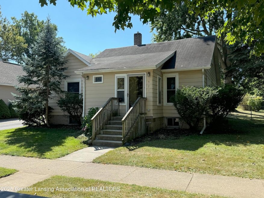


Charming 3 bedroom home located in the heart of Mason, offering timeless appeal with original hardwood floors throughout. This well-maintained residence features an inviting living space, a functional kitchen with ample cabinetry and good-sized bedrooms. It is situated on a quiet street just a short distance from downtown Mason. Enjoy access to local shops, parks and schools. The spacious backyard provides room to relax, garden or entertain. Ideal for first-time buyers or those seeking a cozy home in a vibrant community.
Last Agent to Sell the Property
WEICHERT, REALTORS- Emerald Properties License #6501464530 Listed on: 09/03/2025

Last Buyer's Agent
Lisa Cain Associates
Berkshire Hathaway HomeServices
| Date | Type | Sale Price | Title Company |
|---|---|---|---|
| Warranty Deed | $190,000 | Ata National Title | |
| Quit Claim Deed | $32,000 | None Listed On Document | |
| Quit Claim Deed | $32,000 | None Listed On Document | |
| Quit Claim Deed | $32,000 | None Listed On Document | |
| Deed | -- | None Listed On Document | |
| Deed | -- | None Listed On Document | |
| Corporate Deed | $20,000 | -- |
| Date | Event | Price | List to Sale | Price per Sq Ft |
|---|---|---|---|---|
| 10/16/2025 10/16/25 | Sold | $190,000 | +0.5% | $162 / Sq Ft |
| 09/03/2025 09/03/25 | For Sale | $189,000 | -- | $162 / Sq Ft |
| Year | Tax Paid | Tax Assessment Tax Assessment Total Assessment is a certain percentage of the fair market value that is determined by local assessors to be the total taxable value of land and additions on the property. | Land | Improvement |
|---|---|---|---|---|
| 2025 | $2,670 | $86,210 | $28,950 | $57,260 |
| 2024 | $2,499 | $81,300 | $27,250 | $54,050 |
| 2023 | $2,499 | $73,270 | $22,140 | $51,130 |
| 2022 | $2,384 | $69,650 | $25,110 | $44,540 |
| 2021 | $2,295 | $61,450 | $25,110 | $36,340 |
| 2020 | $2,259 | $57,930 | $25,110 | $32,820 |
| 2019 | $2,172 | $54,950 | $20,090 | $34,860 |
| 2018 | $2,133 | $45,000 | $20,090 | $30,150 |
| 2017 | $1,936 | $50,240 | $20,090 | $30,150 |
| 2016 | -- | $41,390 | $10,040 | $31,350 |
| 2015 | -- | $36,850 | $20,086 | $16,764 |
| 2014 | -- | $37,740 | $26,781 | $10,959 |
J
Seller's Agent in 2025
Joshua Allen
WEICHERT, REALTORS- Emerald Properties
(517) 667-9365
1 in this area
3 Total Sales
L
Buyer's Agent in 2025
Lisa Cain Associates
Berkshire Hathaway HomeServices
Source: Greater Lansing Association of Realtors®
MLS Number: 290965
APN: 19-10-08-206-006
Disclaimer: Certain information contained herein is derived from information provided by parties other than Homes.com. All information provided is deemed reliable, but is not guaranteed to be accurate and should be independently verified.
![]() IDX information is provided exclusively for Consumers'
IDX information is provided exclusively for Consumers'
personal, non-commercial use, that it may not be used for any purpose other than to identify prospective properties Consumers may be interested in purchasing. Data is deemed reliable but is not guaranteed accurate by the MLS.
Copyright © 2026 Greater Lansing Association of REALTORS®
Ask me questions while you tour the home.