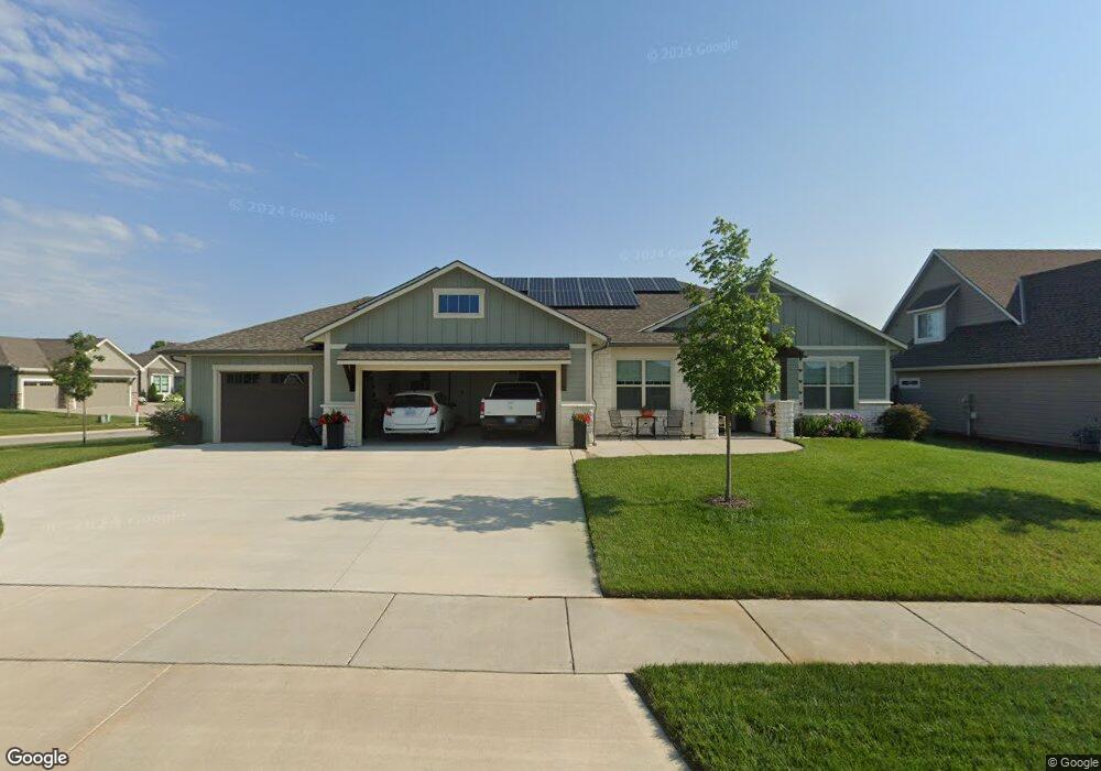
5222 Cedar Grove Ct Lawrence, KS 66049
West Lawrence NeighborhoodEstimated Value: $548,000 - $648,000
3
Beds
3
Baths
2,405
Sq Ft
$243/Sq Ft
Est. Value
About This Home
This home is located at 5222 Cedar Grove Ct, Lawrence, KS 66049 and is currently estimated at $585,592, approximately $243 per square foot. 5222 Cedar Grove Ct is a home with nearby schools including Langston Hughes Elementary School, Southwest Middle School, and Lawrence Free State High School.
Ownership History
Date
Name
Owned For
Owner Type
Purchase Details
Closed on
Jan 17, 2023
Sold by
Drickey Donald C and Drickey Jeanne M
Bought by
Drickey Family Trust
Current Estimated Value
Purchase Details
Closed on
Mar 12, 2020
Sold by
Ezell Morgan Construction Company Inc
Bought by
Drickey Donald C and Drickey Jeanne M
Home Financials for this Owner
Home Financials are based on the most recent Mortgage that was taken out on this home.
Original Mortgage
$415,000
Interest Rate
3.4%
Mortgage Type
Construction
Purchase Details
Closed on
May 14, 2019
Sold by
We1929 Llc
Bought by
Ezell Morgan Construction Company Inc
Create a Home Valuation Report for This Property
The Home Valuation Report is an in-depth analysis detailing your home's value as well as a comparison with similar homes in the area
Home Values in the Area
Average Home Value in this Area
Purchase History
| Date | Buyer | Sale Price | Title Company |
|---|---|---|---|
| Drickey Family Trust | -- | -- | |
| Drickey Donald C | -- | Kansas Secured Title | |
| Ezell Morgan Construction Company Inc | -- | Kansas Secured Ttl Inc Lawre |
Source: Public Records
Mortgage History
| Date | Status | Borrower | Loan Amount |
|---|---|---|---|
| Previous Owner | Drickey Donald C | $415,000 |
Source: Public Records
Tax History Compared to Growth
Tax History
| Year | Tax Paid | Tax Assessment Tax Assessment Total Assessment is a certain percentage of the fair market value that is determined by local assessors to be the total taxable value of land and additions on the property. | Land | Improvement |
|---|---|---|---|---|
| 2025 | $8,247 | $65,665 | $9,200 | $56,465 |
| 2024 | $8,121 | $64,642 | $8,625 | $56,017 |
| 2023 | $7,431 | $57,408 | $8,050 | $49,358 |
| 2022 | $6,983 | $53,602 | $8,050 | $45,552 |
| 2021 | $6,859 | $51,129 | $7,820 | $43,309 |
| 2020 | $1,209 | $9,000 | $9,000 | $0 |
| 2019 | $1,208 | $9,000 | $9,000 | $0 |
| 2018 | $8 | $0 | $0 | $0 |
Source: Public Records
Map
Nearby Homes
- 5024 Cedar Grove Way
- 1202 Little Knife
- 5117 Harvard Rd
- 1300 Research Park Dr
- 1315 Research Park Dr
- 5204 Foxchase Dr
- 5204 Fox Chase Dr
- 1040 Stonecreek Dr
- 1017 Stoneridge Dr
- 1033 Stonecreek Dr
- 904 Moundridge Dr
- 1347 Kanza Dr
- 5245 Overland Dr Unit A15
- 5245 Overland Dr Unit C12
- 5245 Overland Dr Unit D4
- 5710 Goff Ct
- 1601 Research Park Dr
- 1564 Fountain Dr
- 5614 Chimney Rocks Cir
- 1204 Chadwick Ct
- 5215 Cedar Grove Ct
- 5215 Cedar Grove Ct
- 5214 Cedar Grove Ct
- 5210 Cedar Grove Ct
- 5211 Cedar Grove Ct
- 5219 Cedar Grove Ct
- 5207 Cedar Grove Ct
- 5202 Cedar Grove Ct
- 5202 Cedar Grove Ct
- 5207 Cedar Grove
- 5223 Cedar Grove Ct
- 5209 Cedar Grove Way
- 5205 Cedar Grove Way
- 5213 Cedar Grove Way
- 5201 Cedar Grove Way
- 5212 Spruce St
- 5220 Spruce St
- 5216 Spruce St
- 5218 Spruce St
- 1128 Juniper Ln