
Seller's Agent in 2025
Ann Bennett
EXP Realty
(603) 682-7744
3 in this area
116 Total Sales

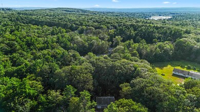


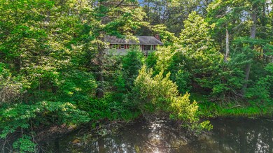
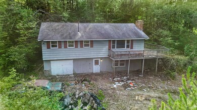
This 3-bedroom, 1-bathroom raised ranch sits on an impressive 22 acres that stretches right to the Massachusetts state line. While the home is being sold in its current condition and needs some love to make it livable again, it presents an incredible opportunity for someone with vision. The real star here is the expansive lot size – 22 acres of possibilities waiting for your creative touch. Whether you're dreaming of building your perfect home, creating a weekend retreat, or developing the land, this property offers the space to make it happen. The location couldn't be better, with easy access to Route 202 for convenient commuting. Outdoor enthusiasts will appreciate being just minutes from Lake Monomonac, where boating, kayaking, canoeing, swimming, and fishing are practically at your doorstep. The nearby Rindge Town Forest adds even more recreational opportunities for hiking and nature lovers. This property is perfect for buyers who aren't afraid to roll up their sleeves and see potential where others might see work. The generous acreage provides privacy and room to breathe, while the proximity to both New Hampshire and Massachusetts gives you the best of both states. Market Basket is nearby for shopping convenience, making this location both secluded and practical. If you're looking for a project with serious upside potential and enough land to truly call your own, this could be your diamond in the rough. Sometimes the best opportunities come diguised as fixer-uppers.
Last Agent to Sell the Property
EXP Realty Brokerage Phone: 603-682-7744 License #070324 Listed on: 08/01/2025
| Date | Type | Sale Price | Title Company |
|---|---|---|---|
| Fiduciary Deed | $260,000 | -- | |
| Fiduciary Deed | $260,000 | -- | |
| Fiduciary Deed | $260,000 | -- | |
| Warranty Deed | $115,000 | -- | |
| Warranty Deed | $115,000 | -- |
| Date | Status | Loan Amount | Loan Type |
|---|---|---|---|
| Previous Owner | $76,443 | Unknown | |
| Previous Owner | $92,000 | Purchase Money Mortgage |
| Date | Event | Price | List to Sale | Price per Sq Ft |
|---|---|---|---|---|
| 08/20/2025 08/20/25 | Sold | $260,000 | +4.0% | $206 / Sq Ft |
| 08/06/2025 08/06/25 | Pending | -- | -- | -- |
| 08/01/2025 08/01/25 | For Sale | $250,000 | -- | $198 / Sq Ft |
| Year | Tax Paid | Tax Assessment Tax Assessment Total Assessment is a certain percentage of the fair market value that is determined by local assessors to be the total taxable value of land and additions on the property. | Land | Improvement |
|---|---|---|---|---|
| 2024 | $4,878 | $192,748 | $50,148 | $142,600 |
| 2023 | $4,835 | $193,100 | $50,500 | $142,600 |
| 2022 | $4,447 | $193,100 | $50,500 | $142,600 |
| 2021 | $4,374 | $193,100 | $50,500 | $142,600 |
| 2020 | $4,337 | $193,173 | $50,573 | $142,600 |
| 2019 | $3,895 | $140,314 | $40,414 | $99,900 |
| 2018 | $3,863 | $140,481 | $40,581 | $99,900 |
| 2017 | $3,815 | $140,314 | $40,414 | $99,900 |
| 2016 | $3,916 | $140,314 | $40,414 | $99,900 |
| 2015 | $3,913 | $140,314 | $40,414 | $99,900 |
| 2014 | $3,952 | $151,814 | $70,314 | $81,500 |
| 2013 | $3,901 | $153,220 | $71,720 | $81,500 |
Seller's Agent in 2025
Ann Bennett
EXP Realty
(603) 682-7744
3 in this area
116 Total Sales
Buyer's Agent in 2025
Alicia Salo
Banner Realty
(603) 491-5606
11 in this area
56 Total Sales
Source: PrimeMLS
MLS Number: 5054623
APN: RIND-000002-000071
Disclaimer: Certain information contained herein is derived from information provided by parties other than Homes.com. All information provided is deemed reliable, but is not guaranteed to be accurate and should be independently verified.
![]() Copyright 2025 PrimeMLS, Inc. All rights reserved. This information is deemed reliable, but not guaranteed. The data relating to real estate displayed on this display comes in part from the IDX Program of PrimeMLS. The information being provided is for consumers’ personal, non-commercial use and may not be used for any purpose other than to identify prospective properties consumers may be interested in purchasing.
Copyright 2025 PrimeMLS, Inc. All rights reserved. This information is deemed reliable, but not guaranteed. The data relating to real estate displayed on this display comes in part from the IDX Program of PrimeMLS. The information being provided is for consumers’ personal, non-commercial use and may not be used for any purpose other than to identify prospective properties consumers may be interested in purchasing.