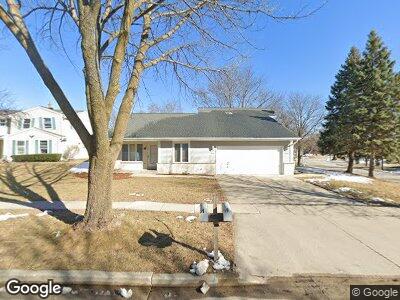
5596 Serene Ct Unit 98 Greendale, WI 53129
Estimated Value: $442,000 - $542,000
--
Bed
--
Bath
2,801
Sq Ft
$175/Sq Ft
Est. Value
About This Home
This home is located at 5596 Serene Ct Unit 98, Greendale, WI 53129 and is currently estimated at $489,161, approximately $174 per square foot. 5596 Serene Ct Unit 98 is a home located in Milwaukee County with nearby schools including Highland View Elementary School, Greendale Middle School, and Greendale High School.
Ownership History
Date
Name
Owned For
Owner Type
Purchase Details
Closed on
Mar 24, 2016
Sold by
Liv Doherty Daniel W
Bought by
Doherty Serene Court Llc
Current Estimated Value
Purchase Details
Closed on
Oct 26, 2015
Sold by
Uzelac Townhouse Llc
Bought by
Liv Doherty Daniel W and Daniel W Doherty Revocable Living Trust
Purchase Details
Closed on
Apr 7, 2009
Sold by
Uzelac Nada M and Uzelac Michael
Bought by
Uzelac Townhouse Llc
Purchase Details
Closed on
Mar 15, 2002
Sold by
Uzelac Michael and Uzelac Nada
Bought by
Uzelac Nada M
Create a Home Valuation Report for This Property
The Home Valuation Report is an in-depth analysis detailing your home's value as well as a comparison with similar homes in the area
Home Values in the Area
Average Home Value in this Area
Purchase History
| Date | Buyer | Sale Price | Title Company |
|---|---|---|---|
| Doherty Serene Court Llc | -- | None Available | |
| Liv Doherty Daniel W | $298,000 | Attorney | |
| Uzelac Townhouse Llc | -- | None Available | |
| Uzelac Nada M | -- | -- |
Source: Public Records
Mortgage History
| Date | Status | Borrower | Loan Amount |
|---|---|---|---|
| Previous Owner | Uzelac Townhouse Llc | $179,300 | |
| Previous Owner | Uzelac Townhouse Llc | $223,649 | |
| Previous Owner | Uzelac Michael M | $248,000 | |
| Previous Owner | Uzelac Michael | $200,000 |
Source: Public Records
Tax History Compared to Growth
Tax History
| Year | Tax Paid | Tax Assessment Tax Assessment Total Assessment is a certain percentage of the fair market value that is determined by local assessors to be the total taxable value of land and additions on the property. | Land | Improvement |
|---|---|---|---|---|
| 2023 | $7,918 | $403,500 | $64,300 | $339,200 |
| 2022 | $7,947 | $403,500 | $64,300 | $339,200 |
| 2021 | $8,639 | $334,500 | $57,400 | $277,100 |
| 2020 | $8,521 | $334,500 | $57,400 | $277,100 |
| 2019 | $8,539 | $334,500 | $57,400 | $277,100 |
| 2018 | $8,728 | $334,500 | $57,400 | $277,100 |
| 2017 | $7,665 | $301,600 | $55,200 | $246,400 |
| 2016 | $7,626 | $301,600 | $55,200 | $246,400 |
| 2015 | $5,747 | $218,400 | $55,200 | $163,200 |
| 2014 | $5,722 | $218,400 | $55,200 | $163,200 |
| 2013 | $5,822 | $218,400 | $55,200 | $163,200 |
Source: Public Records
Map
Nearby Homes
- 5154 Maplewood Dr
- 5401 S 45th St
- 5391 S 45th St Unit 29
- 5590 Leroy Ln
- 5540 Leroy Ln
- 5510 S 43rd St
- 5717 S 42nd St
- 5345 S 43rd St
- 5751 S 42nd St
- 5863 Sugarbush Ln
- 5475 Olympia Dr
- 6020 Briarclift Ct
- 4759 W Abbott Ave
- 3726 W Birchwood Ave
- 6190 W Loomis Rd
- 5371 S Butterfield Way Unit 5371
- 5863 Oakwood St
- 5839 S Madeline Ave
- 6101 W Edgerton Ave
- 5863 S Madeline Ave
- 5596 Serene Ct Unit 98
- 5588 Serene Ct Unit 90
- 4990 Sutton Ln Unit 92
- 5574 Serene Ct
- 4980 Sutton Ln
- 4982 Sutton Ln
- 5090 Steeple Dr
- 5595 Serene Ct Unit 97
- 5595 Serene Ct Unit 5597
- 5587 Serene Ct Unit 89
- 4970 Sutton Ln Unit 72
- 5566 Serene Ct Unit 68
- 5573 Serene Ct Unit 75
- 5080 Steeple Dr
- 4960 Sutton Ln
- 4995 Sutton Ln
- 5095 Steeple Dr
- 5070 Steeple Dr
- 4940 Sutton Ln
- 5545 Serene Ct Unit 47