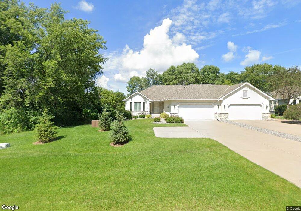
5619 Portland Ave Saint Paul, MN 55110
Estimated Value: $573,794 - $640,000
4
Beds
3
Baths
1,937
Sq Ft
$319/Sq Ft
Est. Value
About This Home
This home is located at 5619 Portland Ave, Saint Paul, MN 55110 and is currently estimated at $616,949, approximately $318 per square foot. 5619 Portland Ave is a home located in Ramsey County with nearby schools including Lincoln Elementary School, Central Middle School, and St. Jude of the Lake Catholic School.
Ownership History
Date
Name
Owned For
Owner Type
Purchase Details
Closed on
Oct 31, 2018
Sold by
Norstrem Nancy A
Bought by
Norstrem Paul R and Norstrem Family Irrevocable Trust
Current Estimated Value
Purchase Details
Closed on
Feb 27, 2003
Sold by
Hay John A and Hay Sherrie F
Bought by
Norstrem Gary R and Norstrem Virginia A
Purchase Details
Closed on
Mar 29, 2001
Sold by
Wooddale Builders Inc
Bought by
Hay John A and Hay Sherrie F
Purchase Details
Closed on
Jan 9, 1998
Sold by
Royal Oaks Realty Inc
Bought by
Wooddale Builders Inc
Create a Home Valuation Report for This Property
The Home Valuation Report is an in-depth analysis detailing your home's value as well as a comparison with similar homes in the area
Home Values in the Area
Average Home Value in this Area
Purchase History
| Date | Buyer | Sale Price | Title Company |
|---|---|---|---|
| Norstrem Paul R | -- | None Available | |
| Norstrem Nancy A | -- | None Available | |
| Norstrem Gary R | $396,000 | -- | |
| Hay John A | $343,750 | -- | |
| Wooddale Builders Inc | $370,000 | -- |
Source: Public Records
Tax History Compared to Growth
Tax History
| Year | Tax Paid | Tax Assessment Tax Assessment Total Assessment is a certain percentage of the fair market value that is determined by local assessors to be the total taxable value of land and additions on the property. | Land | Improvement |
|---|---|---|---|---|
| 2025 | $7,024 | $552,000 | $100,000 | $452,000 |
| 2023 | $7,024 | $534,000 | $100,000 | $434,000 |
| 2022 | $5,856 | $488,800 | $100,000 | $388,800 |
| 2021 | $5,670 | $420,400 | $100,000 | $320,400 |
| 2020 | $5,324 | $420,400 | $100,000 | $320,400 |
| 2019 | $5,566 | $378,900 | $45,500 | $333,400 |
| 2018 | $5,404 | $421,000 | $45,500 | $375,500 |
| 2017 | $5,250 | $416,300 | $45,500 | $370,800 |
| 2016 | $5,290 | $0 | $0 | $0 |
| 2015 | $5,004 | $378,900 | $45,500 | $333,400 |
| 2014 | $5,210 | $0 | $0 | $0 |
Source: Public Records
Map
Nearby Homes
- 2656 Richard Dr
- 5553 Fenway Ct
- 5347 Portland Ave
- 5924 Polar Bear Ln
- 5285 Northwest Ave
- 2574 1st St
- 5234 Grand Ave
- 2655 Stillwater St
- TBD Park Ave
- 5264 Pathways Ave
- 5200 Pathways Ave Unit 105
- 5366 Eagle St
- 2177 Overlake Ave
- 42 Eldorado Cir
- 7 Bayhill Rd
- 5246 Division Ave
- 1 Bayhill Rd
- 22 Dellwood Ave
- 11 High Point Rd
- 12112 121st St N
- 5621 Portland Ave
- 5631 Portland Ave
- 5633 Portland Ave
- 2627 Cristine Ct
- 2569 Parkview Ct
- 0 Unassigned
- 2579 Parkview Ct
- 2628 Richard Dr
- 2567 Parkview Ct
- 2581 Parkview Ct
- 5645 Portland Ave
- 2568 Parkview Ct
- 2591 Parkview Ct
- 2626 Cristine Ct
- 2634 Richard Dr
- 2593 Parkview Ct
- 2570 Parkview Ct
- 0 Unassigned
- 0 Unassigned
- 5650 Portland Ave