Estimated Value: $427,913 - $884,000
3
Beds
1
Bath
1,782
Sq Ft
$340/Sq Ft
Est. Value
About This Home
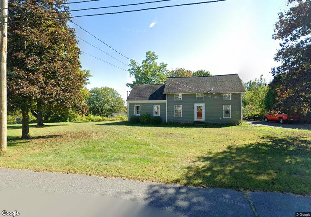
This home is located at 57 Upland Rd, Leeds, MA 01053 and is currently estimated at $605,478, approximately $339 per square foot. 57 Upland Rd is a home located in Hampshire County with nearby schools including Northampton High School, The Montessori School of Northampton, and Lander Grinspoon Academy.
Ownership History
Date
Name
Owned For
Owner Type
Purchase Details
Closed on
Jul 8, 2014
Sold by
Quinn Thomas F and Quinn Edward J
Bought by
Quinn Thomas F and Quinn Amy B
Current Estimated Value
Purchase Details
Closed on
Aug 17, 2004
Sold by
Quinn Mark D
Bought by
Quinn Thomas F and Quinn Edward J
Create a Home Valuation Report for This Property
The Home Valuation Report is an in-depth analysis detailing your home's value as well as a comparison with similar homes in the area
Home Values in the Area
Average Home Value in this Area
Purchase History
| Date | Buyer | Sale Price | Title Company |
|---|---|---|---|
| Quinn Thomas F | -- | -- | |
| Quinn Thomas F | -- | -- |
Source: Public Records
Mortgage History
| Date | Status | Borrower | Loan Amount |
|---|---|---|---|
| Previous Owner | Quinn Thomas F | $35,000 |
Source: Public Records
Tax History
| Year | Tax Paid | Tax Assessment Tax Assessment Total Assessment is a certain percentage of the fair market value that is determined by local assessors to be the total taxable value of land and additions on the property. | Land | Improvement |
|---|---|---|---|---|
| 2025 | $5,324 | $382,200 | $114,100 | $268,100 |
| 2024 | $4,893 | $322,100 | $108,900 | $213,200 |
| 2023 | $5,018 | $316,800 | $98,900 | $217,900 |
| 2022 | $4,691 | $262,200 | $92,700 | $169,500 |
| 2021 | $4,049 | $233,100 | $88,500 | $144,600 |
| 2020 | $3,916 | $233,100 | $88,500 | $144,600 |
| 2019 | $3,528 | $203,100 | $93,500 | $109,600 |
| 2018 | $3,589 | $210,600 | $93,500 | $117,100 |
| 2017 | $3,515 | $210,600 | $93,500 | $117,100 |
| 2016 | $3,403 | $210,600 | $93,500 | $117,100 |
| 2015 | $3,217 | $203,600 | $88,500 | $115,100 |
| 2014 | $3,133 | $203,600 | $88,500 | $115,100 |
Source: Public Records
Map
Nearby Homes
- 48 Evergreen Rd Unit 306
- 44 Evergreen Rd Unit 302
- 53 E Center St
- 0 Haydenville Rd
- 139 Water St
- 222 River Rd
- 214 Audubon Rd
- 3 Deer Haven Dr
- 2 Juniper Place
- 158 Main St
- 67 Park St Unit A
- 76 Maple St
- 17 Mountain St Unit B
- 42 Clark St
- 37 Landy Ave
- 575 Bridge Rd Unit 12-7
- 575 Bridge Rd Unit 10-5
- 296 Ryan Rd Unit A
- 296 Ryan Rd
- 296 Ryan Rd Unit B
- 17 Chestnut Ave
- 52 Upland Rd
- 9 Chestnut Ave Unit EXT
- 100 Front St
- 12 Leonard St
- 88 Front St
- 75 Upland Rd
- Lot 25 Chestnut Ave Extension
- Lot 24 Chestnut Ave Extension
- 110 Front St
- 58 Upland Rd
- 54 Upland Rd
- 46 Upland Rd
- 72 Upland Rd
- 18 Chestnut Ave
- (Lot 9) 64 Chestnut Ave Extension
- (Lot 10)66 Chestnut Ave Extension
- 68 lot 11 Chestnut Ave Extension
- 70 lot 12 Chestnut Ave Extension
- 2 Chestnut Ave
Your Personal Tour Guide
Ask me questions while you tour the home.