M
Seller's Agent in 2020
Michele Casavant
Vineyard Village Realty

Estimated Value: $3,452,000 - $4,797,000
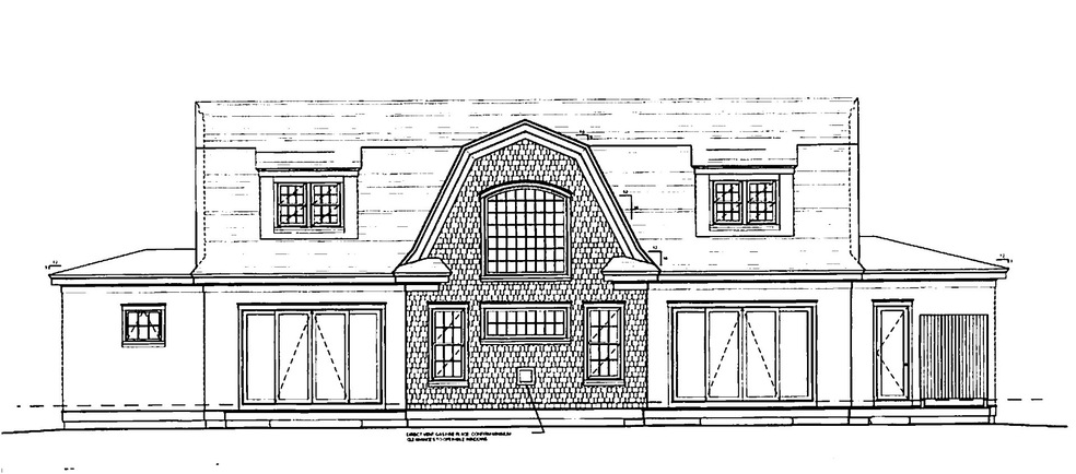
NEW CONSTRUCTION, with POOL, near Edgartown Village! 3,431 square feet of open living space. The Great Room has a dramatic Two Story wall of windows which surround a gas fireplace and overlooks the 14 x 30 foot pool. In addition to the dramatic Great Room there is a first floor study, a first floor master-en-suite, a mud room and separate laundry area. The Gourmet Kitchen, with it's central island, opens to the dining room which flows into the Great Room. The second floor offers a second master-en-suite, as well as two additional bedrooms which share a full bath. Architecturally designed and plotted detached two car garage with a 400 sq. ft bedroom with full bath above. Truly a MUST SEE offering!
Last Agent to Sell the Property
Michele Casavant
Vineyard Village Realty Listed on: 08/09/2019
Last Buyer's Agent
Emma Kennedy
Sandpiper Realty
| Date | Buyer | Sale Price | Title Company |
|---|---|---|---|
| Macdougall Michael | $2,700,000 | None Available | |
| Msk Llc | -- | -- | |
| Katama South Holdings | -- | -- | |
| Seacoast Developers Ll | $3,958,333 | -- |
| Date | Status | Borrower | Loan Amount |
|---|---|---|---|
| Open | Macdougall Michael | $2,000,000 | |
| Previous Owner | Seacoast Developers Ll | $4,063,128 |
| Date | Event | Price | List to Sale | Price per Sq Ft |
|---|---|---|---|---|
| 09/01/2020 09/01/20 | Sold | $2,700,000 | -1.8% | $787 / Sq Ft |
| 08/10/2019 08/10/19 | Pending | -- | -- | -- |
| 08/09/2019 08/09/19 | For Sale | $2,750,000 | -- | $802 / Sq Ft |
| Year | Tax Paid | Tax Assessment Tax Assessment Total Assessment is a certain percentage of the fair market value that is determined by local assessors to be the total taxable value of land and additions on the property. | Land | Improvement |
|---|---|---|---|---|
| 2025 | $10,504 | $3,963,800 | $1,119,900 | $2,843,900 |
| 2024 | $9,728 | $3,814,800 | $1,119,900 | $2,694,900 |
| 2023 | $9,520 | $3,777,900 | $1,172,300 | $2,605,600 |
| 2022 | $7,911 | $2,610,900 | $1,076,800 | $1,534,100 |
| 2021 | $5,128 | $1,563,300 | $986,300 | $577,000 |
| 2020 | $3,004 | $896,600 | $896,600 | $0 |
| 2019 | $3,759 | $971,300 | $971,300 | $0 |
| 2018 | $3,759 | $971,300 | $971,300 | $0 |
| 2017 | $2,653 | $747,200 | $747,200 | $0 |
M
Seller's Agent in 2020
Michele Casavant
Vineyard Village Realty
E
Buyer's Agent in 2020
Emma Kennedy
Sandpiper Realty
Source: LINK (Vineyard)
MLS Number: 35683
APN: EDGA-000029A-000097-000003
Ask me questions while you tour the home.