
Seller's Agent in 2025
Caroline Molla
Costello Realty
(508) 954-9114
5 in this area
34 Total Sales
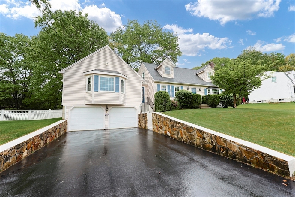
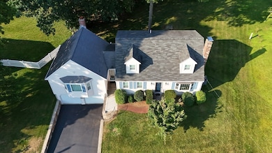
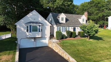
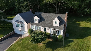
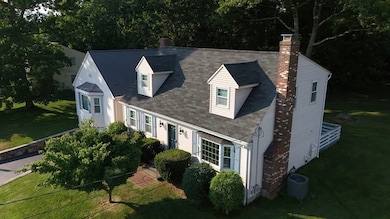
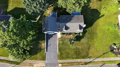
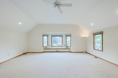
Meticulously maintained original owner home in a highly desirable neighborhood! One of the top features of this beautiful cape is the sun filled great room with stunning wood burning fireplace and slider door out to the deck. The open floor plan flows from oversized eat-in kitchen to dining room and into the living room, perfect for any family who loves to entertain! There is a convenient first floor laundry room and full bathroom. This flexible layout allows for a first floor bedroom, office, or den. The second floor features three generous sized bedroom and another full bathroom. Abundance of storage throughout the home. Sit out and enjoy the two freshly painted decks that look over the beautifully landscaped yard. Endless potential in the unfinished lower level. This well loved family home is ready for the next generation to make it their own! UPDATED heating and central air systems.
Home Type
Est. Annual Taxes
Year Built
Lot Details
Parking
Home Design
Interior Spaces
Kitchen
Flooring
Bedrooms and Bathrooms
Laundry
Outdoor Features
Location
Utilities
Listing and Financial Details
Overview
Amenities
Recreation
| Date | Type | Sale Price | Title Company |
|---|---|---|---|
| Leasehold Conv With Agreement Of Sale Fee Purchase Hawaii | $154,000 | -- |
| Date | Status | Loan Amount | Loan Type |
|---|---|---|---|
| Closed | $90,000 | No Value Available | |
| Open | $166,000 | No Value Available | |
| Closed | $190,000 | No Value Available | |
| Closed | $17,000 | No Value Available | |
| Closed | $138,600 | Purchase Money Mortgage |
| Date | Event | Price | Change | Sq Ft Price |
|---|---|---|---|---|
| 07/07/2025 07/07/25 | Sold | $751,000 | +3.6% | $346 / Sq Ft |
| 06/09/2025 06/09/25 | Pending | -- | -- | -- |
| 06/02/2025 06/02/25 | For Sale | $724,900 | -- | $334 / Sq Ft |
| Year | Tax Paid | Tax Assessment Tax Assessment Total Assessment is a certain percentage of the fair market value that is determined by local assessors to be the total taxable value of land and additions on the property. | Land | Improvement |
|---|---|---|---|---|
| 2025 | $7,038 | $605,700 | $332,000 | $273,700 |
| 2024 | $7,023 | $595,700 | $332,000 | $263,700 |
| 2023 | $6,828 | $534,100 | $283,000 | $251,100 |
| 2022 | $6,234 | $443,700 | $222,800 | $220,900 |
| 2021 | $6,355 | $433,800 | $250,200 | $183,600 |
| 2020 | $6,013 | $414,400 | $240,000 | $174,400 |
| 2019 | $5,924 | $404,100 | $229,700 | $174,400 |
| 2018 | $5,530 | $377,500 | $221,500 | $156,000 |
| 2017 | $5,265 | $361,100 | $205,100 | $156,000 |
| 2016 | $5,481 | $378,000 | $220,000 | $158,000 |
| 2015 | $5,446 | $367,000 | $209,000 | $158,000 |
| 2014 | $4,987 | $345,100 | $183,300 | $161,800 |
Seller's Agent in 2025
Caroline Molla
Costello Realty
(508) 954-9114
5 in this area
34 Total Sales
Buyer's Agent in 2025
Nancy Lesperance
Berkshire Hathaway HomeServices Commonwealth Real Estate
(774) 573-7513
5 in this area
62 Total Sales
Source: MLS Property Information Network (MLS PIN)
MLS Number: 73380069
APN: FRAN-000304-000000-000054
Disclaimer: Certain information contained herein is derived from information provided by parties other than Homes.com. All information provided is deemed reliable, but is not guaranteed to be accurate and should be independently verified.
![]() The property listing data and information, or the Images, set forth herein were provided to MLS Property Information Network, Inc. from third party sources, including sellers, lessors and public records, and were compiled by MLS Property Information Network, Inc. The property listing data and information, and the Images, are for the personal, non-commercial use of consumers having a good faith interest in purchasing or leasing listed properties of the type displayed to them and may not be used for any purpose other than to identify prospective properties which such consumers may have a good faith interest in purchasing or leasing. MLS Property Information Network, Inc. and its subscribers disclaim any and all representations and warranties as to the accuracy of the property listing data and information, or as to the accuracy of any of the Images, set forth herein.
The property listing data and information, or the Images, set forth herein were provided to MLS Property Information Network, Inc. from third party sources, including sellers, lessors and public records, and were compiled by MLS Property Information Network, Inc. The property listing data and information, and the Images, are for the personal, non-commercial use of consumers having a good faith interest in purchasing or leasing listed properties of the type displayed to them and may not be used for any purpose other than to identify prospective properties which such consumers may have a good faith interest in purchasing or leasing. MLS Property Information Network, Inc. and its subscribers disclaim any and all representations and warranties as to the accuracy of the property listing data and information, or as to the accuracy of any of the Images, set forth herein.