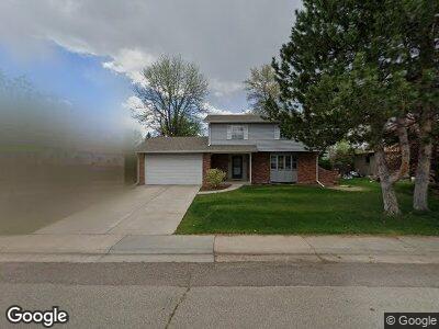
6088 S Marshall Dr Littleton, CO 80123
Leawood NeighborhoodEstimated Value: $612,000 - $699,000
3
Beds
3
Baths
2,031
Sq Ft
$317/Sq Ft
Est. Value
About This Home
This home is located at 6088 S Marshall Dr, Littleton, CO 80123 and is currently estimated at $643,123, approximately $316 per square foot. 6088 S Marshall Dr is a home located in Jefferson County with nearby schools including Leawood Elementary School, Ken Caryl Middle School, and Columbine High School.
Ownership History
Date
Name
Owned For
Owner Type
Purchase Details
Closed on
May 5, 2004
Sold by
Tonelli Florence Lee
Bought by
Tonelli Thomas R and Tonelli Laurie Ann
Current Estimated Value
Home Financials for this Owner
Home Financials are based on the most recent Mortgage that was taken out on this home.
Original Mortgage
$192,000
Interest Rate
4.75%
Mortgage Type
Purchase Money Mortgage
Purchase Details
Closed on
Sep 27, 2000
Sold by
Florence Lee Trustee Tonelli Arthur Louis Tru
Bought by
Tonelli Florence Lee and Florence Lee Tonelli Revocable Living Tr
Purchase Details
Closed on
Dec 27, 1995
Sold by
Tonelli Arthur L and Tonelli Florence L
Bought by
Tonelli Arthur Louis and Tonelli Florence Lee
Create a Home Valuation Report for This Property
The Home Valuation Report is an in-depth analysis detailing your home's value as well as a comparison with similar homes in the area
Home Values in the Area
Average Home Value in this Area
Purchase History
| Date | Buyer | Sale Price | Title Company |
|---|---|---|---|
| Tonelli Thomas R | $240,000 | Title America | |
| Tonelli Florence Lee | -- | -- | |
| Tonelli Arthur Louis | -- | -- |
Source: Public Records
Mortgage History
| Date | Status | Borrower | Loan Amount |
|---|---|---|---|
| Closed | Tonelli Thomas R | $175,200 | |
| Closed | Tonelli Thomas R | $183,000 | |
| Closed | Tonelli Thomas R | $192,000 |
Source: Public Records
Tax History Compared to Growth
Tax History
| Year | Tax Paid | Tax Assessment Tax Assessment Total Assessment is a certain percentage of the fair market value that is determined by local assessors to be the total taxable value of land and additions on the property. | Land | Improvement |
|---|---|---|---|---|
| 2024 | $3,144 | $33,043 | $12,732 | $20,311 |
| 2023 | $3,144 | $33,043 | $12,732 | $20,311 |
| 2022 | $3,058 | $31,517 | $10,125 | $21,392 |
| 2021 | $3,102 | $32,423 | $10,416 | $22,007 |
| 2020 | $2,737 | $28,703 | $8,408 | $20,295 |
| 2019 | $2,700 | $28,703 | $8,408 | $20,295 |
| 2018 | $2,511 | $25,911 | $8,036 | $17,875 |
| 2017 | $2,256 | $25,911 | $8,036 | $17,875 |
| 2016 | $2,271 | $24,486 | $7,531 | $16,955 |
| 2015 | $1,966 | $24,486 | $7,531 | $16,955 |
| 2014 | $1,966 | $19,972 | $5,612 | $14,360 |
Source: Public Records
Map
Nearby Homes
- 6769 W Fair Dr
- 6431 W Arbor Ave
- 6472 W Brittany Place
- 6336 S Newland Ct
- 6071 S Ingalls St
- 6360 S Kendall St
- 6039 W Fair Dr
- 6487 W Weaver Ave
- 6288 S Harlan Way
- 5789 S Jay St
- 6259 S Fenton Ct
- 6614 W Gould Dr
- 6583 W Gould Dr
- 6700 W Dorado Dr Unit 41
- 7314 W Walker Place
- 6541 S Harlan Ct
- 6310 W Sumac Ave
- 6561 S Harlan Ct
- 6531 S Harlan Ct
- 6521 S Harlan Ct
- 6088 S Marshall Dr
- 6082 S Marshall Dr
- 6087 S Lamar Dr
- 6085 S Lamar Dr
- 6093 S Lamar Dr
- 6078 S Marshall Dr
- 6089 S Marshall Dr
- 6083 S Lamar Dr
- 6091 S Marshall Dr
- 6081 S Marshall Dr
- 6097 S Lamar Dr
- 6072 S Marshall Dr
- 6079 S Marshall Dr
- 6093 S Marshall Dr
- 6077 S Lamar Dr
- 6084 S Lamar Dr
- 6594 S Newland Cir
- 6082 S Lamar Dr
- 6086 S Lamar Dr
- 6075 S Lamar Dr